- Kinabalu National Park
-
Kinabalu National Park IUCN Category II (National Park)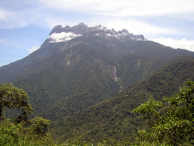 Location of Kinabalu National Park in Malaysia
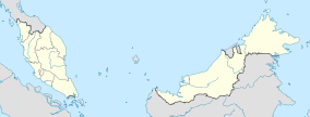

Location Sabah, Malaysia Nearest city Kota Kinabalu Coordinates 6°09′N 116°39′E / 6.15°N 116.65°ECoordinates: 6°09′N 116°39′E / 6.15°N 116.65°E Area 754 km² Established 1964 Governing body Sabah Parks Official name: Kinabalu Park Type: Natural Criteria: ix, x Designated: 2000 (24th session) Reference #: 1012 State Party: Malaysia Region: Asia-Pacific Kinabalu National Park or Taman Negara Kinabalu in Malay, established as one of the first national parks of Malaysia in 1964, is Malaysia's first World Heritage Site designated by UNESCO in December 2000 for its "outstanding universal values" and the role as one of the most important biological sites in the world with more than 4,500 species of flora and fauna, including 326 bird and around 100 mammal species.[1]
Located on the west coast of Sabah, Malaysian Borneo, it covers an area of 754 square kilometers surrounding Mount Kinabalu, which at 4,095.2 metres, is the highest mountain on the island of Borneo.
The park is one of the most popular tourist spots in Sabah and Malaysia in general. In 2004, more than 415,360 visitors and 43,430 climbers visited the Park.
Contents
History
The region was designated as a national park in 1964. British colonial administrator and naturalist Hugh Low led an expedition from Tuaran to the region in 1895. He also became the first recorded man to reach the peak of Mount Kinabalu.[2] The highest peak of the mountain was later named after him—Low's Peak.
Geography
Kinabalu Park is situated on the Crocker Range on the western coast of Sabah. It is located within the district of Ranau, within the West Coast Division. The park is not to be confused with Crocker Range National Park which is a separate park in the south.
The park headquarters is 88 kilometers away from the city of Kota Kinabalu. There are highways and sealed roads leading towards the park headquarters from other parts of Sabah. It is situated on the southern boundary of Kinabalu Park, at an elevation of 1,563 m (5,128 ft).
Administration and park features
 Rajah Lodge accommodation with tree ferns in the foreground
This park is administered by an organization called Sabah Parks. Accommodations in the form of chalets can be found in the park, mostly around the headquarters. Reservations for accommodation and mountain climbing guides are processed through Sutera Sanctuary Lodges (also known as Sutera Harbour), a private company. Every person who wishes to climb the mountain must be accompanied by a qualified guide. Sutera is now requiring hikers stay one night at their lodge near the entrance, in addition to a required stay at Laban Rata. The cost to stay is considerably higher than at lodging just outside the park, and includes a mandatory purchase of meals, etc.
The mountain summit trail begins at Timpohon. There is also an alternative route called the Mesilau Trail.
A notable feature of the park is Low's Gully. It is a 1.6 kilometre deep ravine stretching 10 kilometres on the side of the mountain peak.
Ecology
 Vegetation of the Mount Kinabalu summit plateau
This botanical site contains a variety of flora and fauna that ranges over 4 climate zones; from rich lowland dipterocarp forest through the montane oak, rhododendron, to the coniferous forests, to the alpine meadow plants, and to the stunted bushes of summit zone. The mountain is also known for its many carnivorous plant and orchid species, most notably Nepenthes rajah.
It is also home to a multitude of endemic animal species, including the Kinabalu Giant Red Leech and Kinabalu Giant Earthworm. The park also plays host to a variety of birds, insects, mammals, amphibians, and reptiles.
Mount Kinabalu is one of the youngest non-volcanic mountains in the world. It was formed within the last 10 to 35 million years. The mountain still grows at a rate of 5 millimetres a year.
References
- ^ Chilling out in a tropical destination. The Jakarta Post, June 12, 2011.
- ^ "Kinabalu Park". Sabah Parks. Archived from the original on 2008-08-04. http://web.archive.org/web/20080804033903/http://www.sabahparks.org.my/pages/kinapark.html. Retrieved 2008-11-01.
External links
Protected areas of Sabah World Heritage Site Kinabalu National ParkNational parks Protection forest reserves Danum Valley Conservation Area • Maliau Basin Conservation Area • Silabukan Protection Forest Reserve • Ulu Kalumpang Forest Reserve • Bidu Bidu Forest ReserveOther nature reserves and sanctuaries National parks of Malaysia Peninsular Malaysia Sarawak and Sabah Bako · Batang Ai · Bukit Tiban · Crocker Range · Gunung Buda · Gunung Gading · Gunung Mulu · Kinabalu · Kubah · Kuching Wetlands · Loagan Bunut · Maludam · Niah · Lambir Hills · Pulau Tiga · Pulong Tau · Rajang Mangroves · Similajau · Tanjung Datu · Talang Satang · Tawau Hills · Tun Sakaran · Tunku Abdul Rahman · Turtle IslandsCategories:- IUCN Category II
- Crocker Range
- National parks of Malaysia
- World Heritage Sites in Malaysia
- Association of Southeast Asian Nations heritage parks
- Protected areas established in 1964
- Mount Kinabalu


Wikimedia Foundation. 2010.