- Kalaupapa, Hawaii
Infobox_nrhp | name =Kalaupapa National Historical Park
nrhp_type =nhl
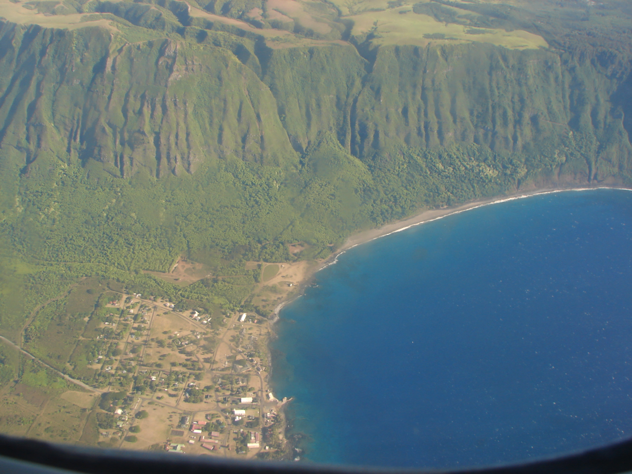
caption = Most of the village of Kalaupapa as seen from an airplane. This photo also includes a section of the sea cliffs that form a natural barrier between the Kalaupapa peninsula and "Topside" Molokai.
location=Kalaupapa, Hawaii
locmapin = Hawaii
lat_degrees = 21
lat_minutes = 11
lat_seconds = 33
lat_direction = N
long_degrees = 156
long_minutes = 59
long_seconds = 10
long_direction = W
area =
built =1866
architect= Board of Health,Hawaii
architecture= Other
added =January 07 ,1976
governing_body = NATIONAL PARK SERVICE
refnum=76002145cite web|url=http://www.nr.nps.gov/|title=National Register Information System|date=2007-01-23|work=National Register of Historic Places|publisher=National Park Service]Kalaupapa is a small
village on the island of Moloka‘i in the state of Hawai‘i, and part ofKalawao County .The village is located on the Kalaupapa peninsula at the base of the highest sea
cliffs in the world, dropping about convert|3315|ft|m|0| into thePacific Ocean .Volcanic origin
Kalaupapa peninsula was created when lava erupted from the ocean floor near
Kauhako Crater and spread outward, forming a low, shield volcano. This was the most recent volcanic episode on the island, occurring after the formation of the cliffs by erosion. Today the dormant crater contains a small lake more than 800 feet (240 m) deep.Leprosy settlement
The village is the site of a former
leprosy settlement. Settlement was first established inKalawao in the east, opposite to the village corner of the peninsula. It was there whereFather Damien settled in1873 . Later it was moved to the location of the current village, which was originally a Hawaiian fishing village. Settlement was also attended byMother Marianne Cope , among others. At its peak, about 1,200 men, women, and children were in exile in this island prison. The isolation law was enacted byKing Kamehameha V and remained in effect until 1969, when it was finally repealed. Today, 4 former sufferers of leprosy—now known as Hansen's Disease—continue to live there. The colony is now part ofKalaupapa National Historical Park .Shortly before the end of mandatory isolation in 1969, the State Legislature considered closing the facility in its entirety. Intervention by interested persons such as entertainer
Don Ho and TV newsman Don Picken resulted in allowing the residents to remain there for life. The opponents to closure pointed out that, although there were no active cases of leprosy in existence, many of the residents were physically scarred by the disease to an extent which would make their integration into mainstream society difficult if not impossible.References
External links
* Tayman, John (2006) The Colony: The Harrowing True Story of the Exiles of Molokai" Scribner [ISBN 0-7432-3300-X]
* [http://www.npr.org/templates/story/story.php?storyId=5183996 "Fear and Loathing in Hawaii: 'Colony'" (NPR Fresh Air, February 2 2006)]
* [http://www.cbsnews.com/stories/2003/03/22/health/main545392.shtml "Last days of a leper colony" (CBS News article, March 22 2003)]
* [http://carl-bell-2.baylor.edu/~bellc/JL/TheLepersOfMolokai.html Jack London's "The Lepers Of Molokai"]
*CathEncy|wstitle=Molokai
* [http://starbulletin.com/2008/02/05/news/story11.html "Sheriff of Kalaupapa demystified disease" (Honolulu Star-Bulletin obituary, February 5 2008)]
Wikimedia Foundation. 2010.