- Orangeburg, New York
-
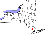
Orangeburg, New York — CDP — Location within the state of New York
 Orangeburg, New York
Coordinates: 41°2′41″N 73°57′12″W / 41.04472°N 73.95333°WCoordinates: 41°2′41″N 73°57′12″W / 41.04472°N 73.95333°W Country United States State New York County Rockland Area - Total 3.1 sq mi (8.0 km2) - Land 3.1 sq mi (8.0 km2) - Water 0.0 sq mi (0.0 km2) Elevation 112 ft (34 m) Population (2000) - Total 3,388 - Density 1,090.7/sq mi (421.1/km2) Time zone Eastern (EST) (UTC-5) - Summer (DST) EDT (UTC-4) ZIP code 10962 Area code(s) 845 FIPS code 36-55167 GNIS feature ID 0959432 Orangeburg hamlet (and census-designated place), in the Town of Orangetown Rockland County, New York, United States located north of Tappan; south of Blauvelt; east of Pearl River and west of Piermont. The population was 3,388 at the 2000 census.
Contents
Geography
Orangeburg is located at 41°2′41″N 73°57′12″W / 41.04472°N 73.95333°W (41.044796, -73.953404)[1].
History
Orangeburg was home to Camp Shanks, “Last Stop USA,” the largest World War II Army embarkation camp, 1.3 million US service personnel en route to Europe were processed at a sprawling camp that covered most of the town. It is also home to what was once one of the world's largest psychiatric hospitals, Rockland Psychiatric Center, formerly called Rockland State Hospital. Orangeburg Pipe was once manufactured here. Before plastic pipes it was the standard alternative to metal pipes especially for sewer and outdoor drainage applications.
After World War II even through it lies only 19 miles (31 km) north of New York City, Orangeburg was a very rural place with few residents many of whom lived quite modestly in former soldier housing. That lasted until the late 1950's when developers introduced modern suburban housing to young couples who saw them as a great alternative to city living. Today, Orangeburg is a suburb of New York City with housing values that belie its modest past.
Demographics
As of the census[2] of 2000, there were 3,388 people, 1,335 households, and 890 families residing in the village. The population density was 1,090.7 per square mile (420.6/km²). There were 1,350 housing units at an average density of 434.6/sq mi (167.6/km²). The racial makeup of the CDP was 80.19% White, 2.21% African American, 0.15% Native American, 14.64% Asian, 1.24% from other races, and 1.56% from two or more races. Hispanic or Latino of any race were 5.58% of the population.
There were 1,335 households out of which 27.2% had children under the age of 18 living with them, 57.8% were married couples living together, 6.4% had a female householder with no husband present, and 33.3% were non-families. 31.4% of all households were made up of individuals and 24.2% had someone living alone who was 65 years of age or older. The average household size was 2.51 and the average family size was 3.17.
In the community the population was spread out with 21.8% under the age of 18, 4.3% from 18 to 24, 25.9% from 25 to 44, 21.5% from 45 to 64, and 26.4% who were 65 years of age or older. The median age was 44 years. For every 100 females there were 87.2 males. For every 100 females age 18 and over, there were 81.4 males.
The median income for a household in the area was $66,045, and the median income for a family was $77,679. Males had a median income of $52,029 versus $40,438 for females. The average home or condo value in 2009 is $497,904 About 1.9% of families and 5.6% of the population were below the poverty line, including 5.6% of those under age 18 and 9.7% of those age 65 or over.
Historical Markers
 The Orangeburg Inn as seen in 1907
- Colonial Orangetown - Orangeburg & Hunt Roads
- Clausland Cemetery - Greenbush Road at Mountain Avenue
- Michael Salyer (March 8, 1757 - April 9, 1810) House - 213 Blue Hill Road
- Shanks Village - 26 Orangeburg Road
- Veterans Memorial Park
Landmarks and places of Interest
- Camp Shanks Museum and Monument - Independence Ave - During World War II over 1.3 million G.I.'s were out processed from Camp Shanks to Europe and South Africa. Italian and German POW's were housed and repatriated here. Located at Independence Avenue & Lowe La. off Western Highway. The museum is located on South Greenbush Road near the intersection of Routes 303 and 340 and is open on weekends.
Public transportation
Orangeburg can be reached from the Port Authority Bus Terminal in Midtown Manhattan on Coach USA Rockland Coaches bus route #20. The #20 bus travels through Orangeburg along Western Highway, where there are stops on Highview Avenue and Orangeburg Road. Additionally, Transport of Rockland (TOR) Bus #92 offers service to Artopee Way in Nyack and to the Spring Valley Transit Center, and TOR Bus #97 offers service from Orangeburg Road and New York State Route 303 to Oak Tree Road in Tappan, New York and to the Park and Ride on Highway 9W in Stony Point, New York.
References
- ^ "US Gazetteer files: 2010, 2000, and 1990". United States Census Bureau. 2011-02-12. http://www.census.gov/geo/www/gazetteer/gazette.html. Retrieved 2011-04-23.
- ^ "American FactFinder". United States Census Bureau. http://factfinder.census.gov. Retrieved 2008-01-31.
External links
Municipalities and communities of Rockland County, New York County seat: New City Towns Clarkstown | Haverstraw | Orangetown | Ramapo | Stony Point
Villages Airmont | Chestnut Ridge | Grand View-on-Hudson | Haverstraw | Hillburn | Kaser | Montebello | New Hempstead | New Square | Nyack | Piermont | Pomona | Sloatsburg | South Nyack | Spring Valley | Suffern | Upper Nyack | Wesley Hills | West Haverstraw
CDPs Bardonia | Blauvelt | Congers | Hillcrest | Monsey | Mount Ivy | Nanuet | New City | Orangeburg | Pearl River | Stony Point | Tappan | Thiells | Valley Cottage | Viola | West Nyack
Other
hamletsCentenary | Central Nyack | Doodletown | Garnerville | Grassy Point | Johnsontown | Jones Point | Ladentown | Middletown | Nauraushaun | Palisades | Rockland Lake | Sandyfield | Sickletown | Sparkill | St. John's in the Wilderness | Sterlington | Tallman | Tomkins Cove
Categories:- Hamlets in New York
- Census-designated places in New York
- Populated places in Rockland County, New York


Wikimedia Foundation. 2010.