- Nea Erythraia
-
Nea Erythraia
Νέα ΕρυθραίαLocation 
 Nea Erythraia
Coordinates 38°5′N 23°49′E / 38.083°N 23.817°ECoordinates: 38°5′N 23°49′E / 38.083°N 23.817°E Location within Athens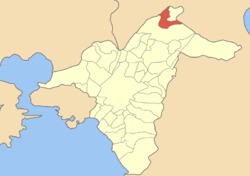
Government Country: Greece Region: Attica Regional unit: North Athens Municipality: Kifisia Population statistics (as of 2001) Municipal unit - Population: 15,439 - Area: 4.831 km2 (2 sq mi) - Density: 3,196 /km2 (8,277 /sq mi) Other Time zone: EET/EEST (UTC+2/3) Elevation (center): 310 m (1,017 ft) Postal: 146 xx Telephone: 210 Auto: Z Website www.dne.gov.gr Nea Erythraia (Greek: Νέα Ερυθραία), is a suburb in the northeastern part of Athens, Greece. Since the 2011 local government reform it is part of the municipality Kifisia, of which it is a municipal unit.[1]
Nea Erythraia is accessed with the GR-1/E75 2.5 km west near the western part of Kifissia; the mountains of Parnitha lie to the west, and are forested, and Penteli lies to the east. It is to be found in the northern part of the Athenian plain, and the Proastiakos runs to the west; the area is located about 6 and 9 km N of the Attiki Odos (number 6), S of Thiva and Chalkida, SW of Marathon, W of Rafina and N of Athens. Its main streets are Venizelou El. Avenue, which links Kifissas Avenue to the south and Agion Saranta Street, and a road linking to Varympompi to Thiseos.
The areas around Nea Erythraia were once made up of farmlands, mainly pastures or groves. Suburban housing arrived in the 1970s and continued to develop slowly in the 2000s, mainly to the west. Much of the population live in larger homes and the population is mainly low density, with larger homes to the west. Forests partially covered parts of the area, and are presently west of Nea Erythraia.
Nea Erythraia used to be a municipality. However, after the drastical overhaul of the administrative system of Greece in 2011, Nea Erythraia became a part of the enlarged Kifissia municipality. The former municipality's boundaries were the Penteli ranges to the east and the Cephissus to the west. For many years, Nea Erythraia was home to the senior division of Campion, one of Greece's oldest English-language schools.
On September 14, 2004, the paralympic flame arrived in Nea Erythraia as it travelled from Marathon.
A dramatic forest fire that began from Penteli on the night of Thursday August 16, 2007, entered the forests of the area and residential areas, burning fewer buildings than in Penteli. Rarely were any fires towering, and even the fires as far east as Penteli were still seen. Firefighters along with a few helicopters battled the blaze for a few hours, which later came to an end. The fire was arson related.
Historical population
Year Population 1981 10,100 1991 12,993 2001 15,439 References
- ^ Kallikratis law Greece Ministry of Interior (Greek)
External links
- City of Nea Erythraia official website (Greek)
- http://emidius.mi.ingv.it/GNDT/T19990907/Athens990907_ismes/ate_html/09.html (Italian)
Northwest: Acharnes North: Kryoneri Northeast: Ekali West: Acharnes and Kifissia Nea Erythraia East: Dionysos South: Kifissia Municipal units Categories:- Populated places in North Athens


Wikimedia Foundation. 2010.