Kawkareik

Kawkareik
Kawkareik
Kawkareik is located in Burma
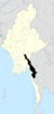
Kawkareik
Location in Burma
Coordinates: 16°33′20″N 98°14′24″E / 16.55556°N 98.24°E / 16.55556; 98.24Coordinates: 16°33′20″N 98°14′24″E / 16.55556°N 98.24°E / 16.55556; 98.24
Country  Burma
Division Kayin State
District Kawkareik District
Township Kawkareik Township
Government
 – Mayor
Population (2005)
 – Religions Buddhism
Time zone MST (UTC+6.30)

Kawkareik (Burmese: ကော့ကရိတ်) is a town in the Kayin State of south Burma. It is the capital of Kawkareik District. The Kawkareik Pass across the Tenasserim Hills is named after this town.

In January 2009, the forces of the Karen National Union and the Democratic Karen Buddhist Army clashed outside of Kawkareik. The DKBA set up their military command post inside the town, and although soldiers burned down several civilian houses and detained dozens of citizens in villages across the border in Thailand, Kawkareik was left intact.[1]

References

External links


Wikimedia Foundation. 2010.

Игры ⚽ Нужно решить контрольную?

Look at other dictionaries:

  • Kawkareik District — (Burmese: ကော့ကရိတ်ခရိုင်, Karen: Dooplaya) is a district of the Kayin State in Myanmar. It consists of 4 towns Kawkareik, the capital, Kyain Seikgyi (Kyalinseikkyi), Kyondo (Kyando), and Payathonsu and 552 villages. Townships The district… …   Wikipedia

  • Kawkareik Township — is a township of Kawkareik District in the Kayin State of Myanmar …   Wikipedia

  • Kawkareik District — Admin ASC 2 Code Orig. name Kawkareik District Country and Admin Code MM.05.8238711 MM …   World countries Adminstrative division ASC I-II

  • Myawaddy Township — မြဝတီမြို့နယ်   township   Coordinates …   Wikipedia

  • Districts of Burma — Burma s states and regions are divided into 67 districts (Burmese: ခရိုင်; Burmese pronunciation: [kʰəjàiɴ]), which in turn are subdivided into townships then towns, wards and villages. Contents 1 List of districts by state or region …   Wikipedia

  • Kayin State — Infobox Burmesestatedivision englishname = Kayin State burmesename = ကရင်ပြည်နယ် transcription = ka.yang pranynai capital = Pa an region = South area = 30,383 population = 1,431,377 ethnic = Kayin, Padaung, Bamar, Shan, Pa O, Mon, Rakhine… …   Wikipedia

  • Myawaddy — This article is about the town in Kayin State, Burma. For other uses, see Myawaddy (disambiguation). Myawaddy မြဝတီ Myawadi Main Street Looking East …   Wikipedia

  • Myawaddy District — (Burmese: မြဝတီခရိုင်) is a district of the Kayin State in Myanmar. It consists 1 towns and 50 villages. Townships The district contains the following townships: Myawaddy Township …   Wikipedia

  • Etat Karen — État Karen État Karen Drapeau de l État Karen …   Wikipédia en Français

  • État Karen — Drapeau de l État Karen …   Wikipédia en Français

Share the article and excerpts

Direct link
Do a right-click on the link above
and select “Copy Link”