- New Bern, North Carolina
-
"New Bern" redirects here. For the fictional city of the TV series Jericho, see New Bern, Kansas.
New Bern, North Carolina — City — New Bern City Hall

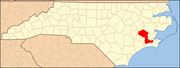
FlagLocation of New Bern, North Carolina
Coordinates: 35°6′33″N 77°4′9″W / 35.10917°N 77.06917°WCoordinates: 35°6′33″N 77°4′9″W / 35.10917°N 77.06917°W Country United States State North Carolina County Craven Government - Mayor Lee Bettis Area - Total 27.0 sq mi (69.9 km2) - Land 25.8 sq mi (66.9 km2) - Water 1.2 sq mi (3.0 km2) Elevation 30 ft (3 m) Population (2008) - Total 29,524 - Density 895.5/sq mi (345.7/km2) Time zone Eastern (EST) (UTC-5) - Summer (DST) EDT (UTC-4) ZIP codes 28560-28564 Area code(s) 252 FIPS code 37-46340[1] GNIS feature ID 1013911[2] Website http://www.newbern-nc.org/ New Bern (pronounced /ˈnjuːbərn/) is a city in Craven County, North Carolina with a population of 29,524 as of the 2010 census. .[3] It is located at the confluence of the Trent and the Neuse rivers. The city is 112 miles (180 km) east of Raleigh and 87 miles (140 km) northeast of Wilmington. Settled in 1710, New Bern is the second oldest town in North Carolina. It served as the capital of the North Carolina colonial government and then briefly as the state capital. It is the county seat of Craven County and the principal city of the New Bern Micropolitan Statistical Area.
Originally a Swiss immigrant settlement, the city is named after the capital of Switzerland, Bern and has a similar flag. The Swiss connection (just as the Dutch in New Amsterdam, and German immigrants in Pennsylvania Dutch) with England was established by Marian exiles and marriages of the Royal House of Stuart, important people in the history of the Calvinism.
The site of a battle during the American Civil War, it was occupied by Union troops from 1862 to the end of the war. They created the Trent River contraband camp to house the many former slaves who migrated to the Union lines for protection and freedom. They worked for pay for the Union and later many of the men were among the nearly 4,000 from North Carolina who enlisted in the United States Colored Troops.
New Bern is commonly known as the birthplace of Pepsi Cola. It is also the setting of the Nicholas Sparks' book, The Notebook. On a segment on NBC's The Today Show aired March 16, 2005, New Bern was one of the best places in the United States to retire which has been a haven for retirees from the northeastern section of the country.
Contents
History
 Historical marker designating New Bern
Varying complex cultures of indigenous peoples had lived along the waterways of North Carolina for thousands of years before Europeans explored the area. New Bern was first settled by Europeans in 1710 by Swiss and German immigrants[4] under the leadership of Christoph de Graffenried, Franz Louis Michel[5][6] and John Lawson. It was named after the (later) capital of Switzerland, Bern. The first permanent seat of the colonial government of North Carolina was located in New Bern. Following the American Revolutionary War, New Bern became the first state capital. Christoph von Graffenried ordered that the layout of the town was made into the shape of a cross, although the town is not in the shape today due to growth of the town and towns surrounding it.
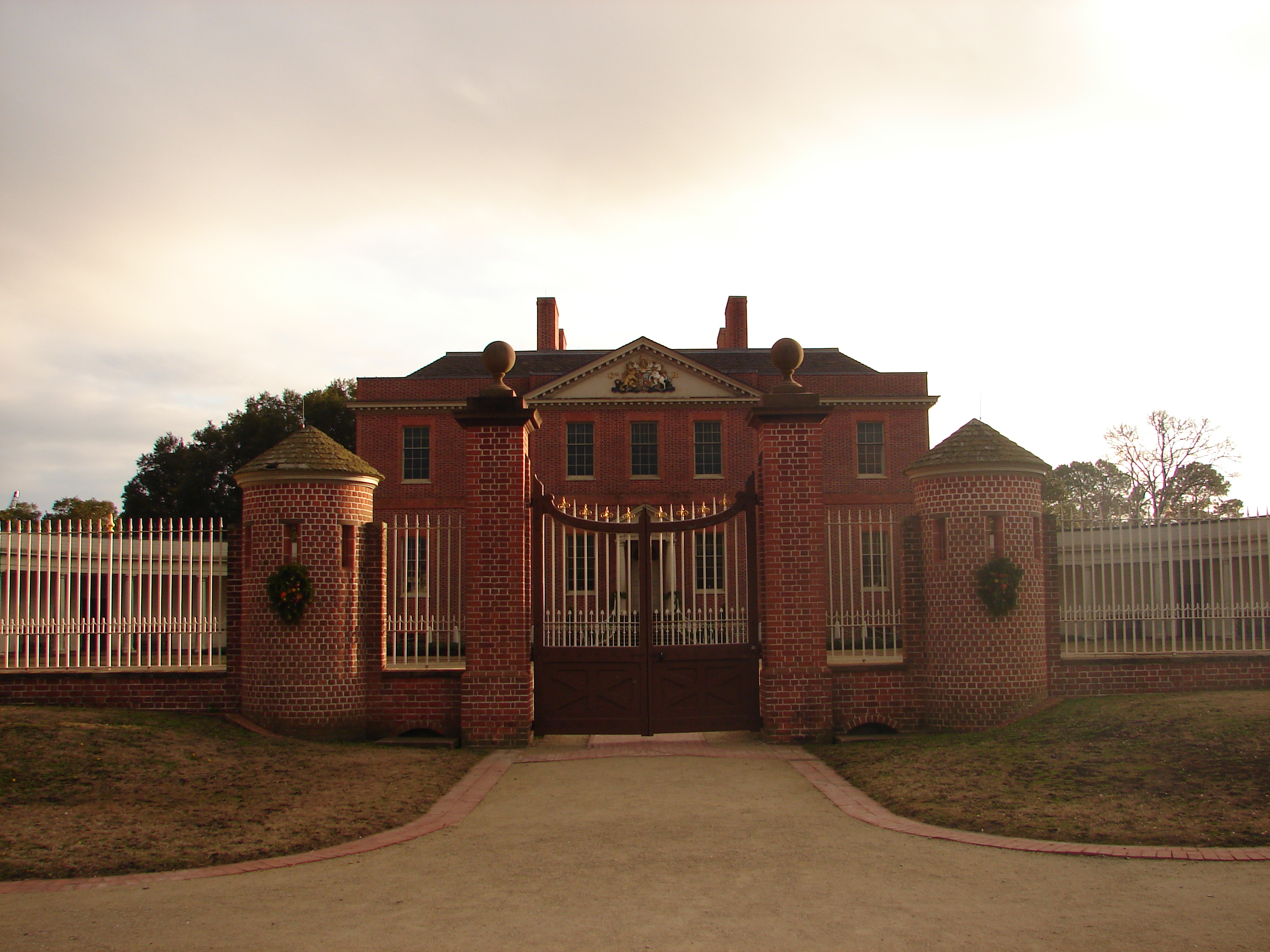
 Reconstructed Tryon Palace in 2008
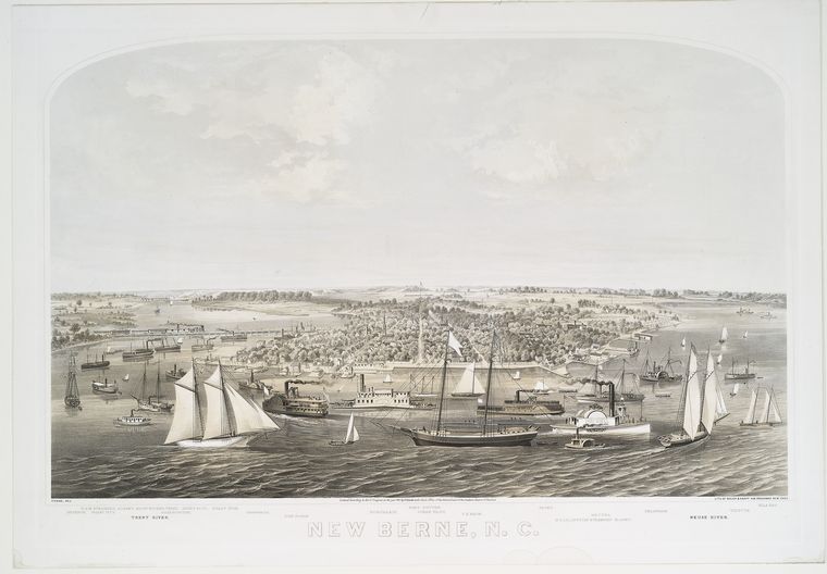
 View of New Bern in 1864
Tryon Palace was completed in 1770 and was the former home of British governor William Tryon. It was used as the original state capitol building of newly independent North Carolina. It burned down in the 1790s. A replica, built from the original plans and on the original foundation, is now maintained as a historic site and tourist attraction. During the 19th-century Federal period, New Bern was the largest city in North Carolina.[7] After Raleigh was named as the state capital, New Bern rebuilt its economy with the help of trade routes to the Caribbean and New England.[7] It reached a population of 3,600 in 1815.[7]
New Bern was the site of the Battle of New Bern early in the American Civil War. The town was captured and occupied by Union forces in 1862. Numerous slaves escaped and went to the Union camps for protection, and the Union Army set up the Trent River contraband camp to house the refugees. After the 1863 Emancipation Proclamation of President Abraham Lincoln, slaves in Union-occupied territories were declared free; more freedmen came to the Trent River camp for protection. The Army appointed Horace James, a Congregational chaplain from Massachusetts, as the "Superintendent of Negro Affairs for the North Carolina District."[8]
In addition to the Trent River camp, James supervised development of the offshore Roanoke Island Freedmen's Colony, which was intended to be self-supporting.[9] These were two of the more than 100 contraband camps established in the South during the war. Many freedmen in the camps worked for pay for the Union Army and contributed to their efforts. Beginning in 1863, a total of nearly 4,000 freedmen from North Carolina enlisted in the United States Colored Troops to fight with the Union for their permanent freedom, including 150 men from the Freedmen's Colony.[8]
Geography
 John Wright Stanly House in New Bern
New Bern is located at 35°6′33″N 77°4′9″W / 35.10917°N 77.06917°W (35.109070, -77.069111)[10].
New Bern is located in North Carolina's Inner Banks region. According to the United States Census Bureau, the city has a total area of 27.0 square miles (69.9 km²), of which, 25.8 square miles (66.9 km²) of it is land and 1.2 square miles (3.0 km²) of it (4.30%) is water.
Climate
New Bern experiences a humid subtropical climate typical of the Atlantic coastal plain. Summers are hot and humid, with frequent afternoon thunderstorms and higher amounts of rainfall. Spring and fall are generally mild, with fall foliage occurring from late October to early November. Winters are chilly to cold, with lower average precipitation and occasional snowfall.
Climate data for New Bern, NC Month Jan Feb Mar Apr May Jun Jul Aug Sep Oct Nov Dec Year Record high °F (°C) 81
(27)88
(31)90
(32)95
(35)100
(38)105
(41)106
(41)103
(39)101
(38)97
(36)87
(31)83
(28)106
(41)Average high °F (°C) 54
(12)57
(14)64
(18)72
(22)79
(26)85
(29)88
(31)87
(31)83
(28)74
(23)66
(19)58
(14)72.25 Average low °F (°C) 34
(1)36
(2)42
(6)50
(10)59
(15)67
(19)71
(22)70
(21)65
(18)53
(12)44
(7)36
(2)52.25 Record low °F (°C) 1
(−17)6
(−14)17
(−8)29
(−2)32
(0)44
(7)55
(13)50
(10)43
(6)26
(−3)17
(−8)−4
(−20)−4
(−20)Rainfall inches (mm) 4.77
(121.2)3.8
(97)4.49
(114)3.4
(86)4.19
(106.4)4.8
(122)6.48
(164.6)6.84
(173.7)5.45
(138.4)3.39
(86.1)3.23
(82)3.84
(97.5)54.68
(1,388.9)Snowfall inches (cm) 1.0
(2.5)0.8
(2)0.5
(1.3)0.1
(0.3)0.0
(0)0.0
(0)0.0
(0)0.0
(0)0.0
(0)0.0
(0)0.1
(0.3)0.2
(0.5)2.7
(6.9)Source: Weatherbase and National Weather Service[11][12] Demographics
Historical populations Year Pop. ±% 1800 2,467 — 1820 3,663 +48.5% 1830 3,796 +3.6% 1840 3,690 −2.8% 1850 4,681 +26.9% 1860 5,432 +16.0% 1870 5,849 +7.7% 1880 6,443 +10.2% 1890 7,843 +21.7% 1900 9,090 +15.9% 1910 9,961 +9.6% 1920 12,198 +22.5% 1930 11,981 −1.8% 1940 11,815 −1.4% 1950 15,812 +33.8% 1960 15,717 −0.6% 1970 14,660 −6.7% 1980 14,557 −0.7% 1990 17,363 +19.3% 2000 23,128 +33.2% 2008 (Est.) 28,586 +23.6% Source: "American FactFinder". United States Census Bureau. http://factfinder.census.gov. As of the 2000 census, there were 23,128 people, 10,006 households, and 6,183 families residing in the city.
The population density was 895.5 people per square mile (345.7/km²). There were 11,094 housing units at an average density of 429.5 per square mile (165.8/km²). The racial composition of the city was: 55.96% White, 40.32% Black or African American, 2.99% Hispanic or Latino American, 0.64% Asian American, 0.32% Native American, 0.04% Native Hawaiian or Other Pacific Islander, 1.44% some other race, and 1.28% two or more races.
There were 10,006 households out of which 27.3% had children under the age of 18 living with them, 40.5% were married couples living together, 18.2% had a female householder with no husband present, and 38.2% were non-families. 33.4% of all households were made up of individuals and 13.2% had someone living alone who was 65 years of age or older. The average household size was 2.26 and the average family size was 2.85.
In the city the population was spread out with 23.9% under the age of 18, 8.3% from 18 to 24, 27.0% from 25 to 44, 22.8% from 45 to 64, and 17.9% who were 65 years of age or older. The median age was 39 years. For every 100 females there were 83.8 males. For every 100 females age 18 and over, there were 79.6 males.
The median income for a household in the city was $29,139, and the median income for a family was $38,990. Males had a median income of $28,720 versus $21,687 for females. The per capita income for the city was $18,499. About 14.7% of families and 19.4% of the population were below the poverty line, including 29.4% of those under age 18 and 14.1% of those age 65 or over.
Education
Colleges
- Craven Community College
- Craven Early College High School
High schools
- New Bern High School
- Craven Early College High School
Middle schools
- Grover C. Fields Middle School
- H.J. McDonald Middle School {Principal Karen Wood}
- West Craven Middle School
Elementary schools
- Trent Park Elementary School
- Oaks Road Elementary School
- J.T. Barber Elementary School
- Brinson Memorial Elementary School
- Ben D. Quinn Elementary School
- Albert H. Bangert Elementary School
- Creekside Elementary School
- Bridgeton Elementary School
Private schools
- Calvary Baptist Christian School
- St. Paul Catholic School (St. Paul Education Center)
- The Epiphany School
Notable people
 Title page of the 1702 Journal of Franz Ludwig Michel of Bern, Switzerland, a founder of New Bern, North Carolina
- Lewis Addison Armistead, Confederate Army brigadier general[13]
- John Heritage Bryan, US Representative
- Davon Drew, Tight end for the Baltimore Ravens
- George Edmund Badger, politician
- Graham Arthur Barden, 13 term congressman (1935–1961).
- Cullen A. Battle, postbellum Mayor of New Bern
- Samuel J. Battle, first African-American policeman in New York City.
- Walt Bellamy, NBA Hall of Fame basketball player
- Caleb Bradham, inventor of Pepsi-Cola.
- Elwood Edwards, voice of AOL's "You've got mail"
- William Gaston, jurist and U.S. Representative
- Montario Hardesty, NFL running back for the Cleveland Browns
- Bob Mann, NFL, Football player, first African-American to play for the Detroit Lions, and later also the Green Bay Packers.
- Aaron Martin, Former NFL player
- Linda McMahon, wife of World Wrestling Entertainment founder Vince McMahon
- Eliza Jane McKissack,First Director and a founding member of the Conservator of Music at the University of North Texas
- George Koonce, NFL player for the Green Bay Packers and Seattle Seahawks, Athletic Director of the University of Wisconsin–Milwaukee
- James E.C. Perry, Justice of the Florida Supreme Court
- Teddy Shapou,Distinguished and awarded Flying Tigerduring World War ll
- Brian Simmons, NFL player
- Furnifold Simmons, U.S. Senator
- Richard Dobbs Spaight, signer of the Declaration of Independence
- Edward Stanly Son of John Stanly,US Representative1837-1843, appointed Military Governor of North Carolina in 1862
- John Stanly, Father of Edward Stanley, Congressman1801-1803 1809-1811
- Adam Warren, baseball player in the New York Yankees organization
- Kevin Meade Williamson, American screen writer, I Know What You Did Last Summer, television series Dawson's Creek
References
- ^ "American FactFinder". United States Census Bureau. http://factfinder.census.gov. Retrieved 2008-01-31.
- ^ "US Board on Geographic Names". United States Geological Survey. 2007-10-25. http://geonames.usgs.gov. Retrieved 2008-01-31.
- ^ "New Bern, North Carolina (NC) Detailed Profile". City-data.com. http://www.city-data.com/city/New-Bern-North-Carolina.html. Retrieved 2009-08-16.
- ^ Bishir, Catherine (2005). North Carolina Architecture. UNC Press. pp. 2. http://books.google.com/books?id=NccTgQkmPIEC.
- ^ "Wilhelmsburg, Colonial Williamsburg, Robert A. Selig, The Potomac Appalachian Trail Club History". Patc.us. http://www.patc.us/history/native/michel2.html. Retrieved 2009-08-16.
- ^ Vincent H. Todd (1920). Christoph Von Graffenried's Account of the Founding of New Bern. Edwards & Broughton Printing Co., Raleigh, North Carolina. http://books.google.com/books?id=RCgpAAAAYAAJ&pg=PA33&lpg=PA33&dq=%22new+bern%22+michel. Retrieved 2009-08-16.
- ^ a b c Bishir, Catherine (2005). North Carolina Architecture. UNC Press. pp. 84. http://books.google.com/books?id=NccTgQkmPIEC.
- ^ a b "The Roanoke Island Freedmen's Colony", provided by National Park Service, at North Carolina Digital History: LEARN NC, accessed 11 November 2010
- ^ Click, Patricia C. "The Roanoke Island Freedmen's Colony", The Roanoke Island Freedmen's Colony Website, 2001, accessed 9 Nov. 2010
- ^ "US Gazetteer files: 2010, 2000, and 1990". United States Census Bureau. 2011-02-12. http://www.census.gov/geo/www/gazetteer/gazette.html. Retrieved 2011-04-23.
- ^ "National Weather Service". National Weather Service. http://forecast.weather.gov/MapClick.php?CityName=New+Bern&state=NC&site=MHX&textField1=35.1199&textField2=-77.0788&e=0. Retrieved 2010-03-25.
- ^ "Weaher Channel: Historical Weather for New Bern, NC". Weatherbase. http://www.weather.com/outlook/travel/businesstraveler/wxclimatology/monthly/graph/USNC0484. Retrieved 2010-01-22.
- ^ Who Was Who in America, Historical Volume, 1607-1896. Marquis Who's Who. 1963.
External links
- Official web site of New Bern, NC
- New Bern's daily newspaper
- Craven County Convention and Visitor's Bureau
- Christoph von Graffenried's account of the founding of New Bern
- Swiss American Historical Society
- New Bern Insider Info
Municipalities and communities of Craven County, North Carolina County seat: New Bern Cities Havelock | New Bern
Towns Bridgeton | Cove City | Dover | River Bend | Trent Woods | Vanceboro
CDPs Military base Categories:- Populated places established in 1710
- Cities in North Carolina
- County seats in North Carolina
- Populated places in Craven County, North Carolina
- Former United States state capitals
- Social history of the American Civil War
- New Bern micropolitan area
- United States colonial and territorial capitals
- New Bern, North Carolina


Wikimedia Foundation. 2010.