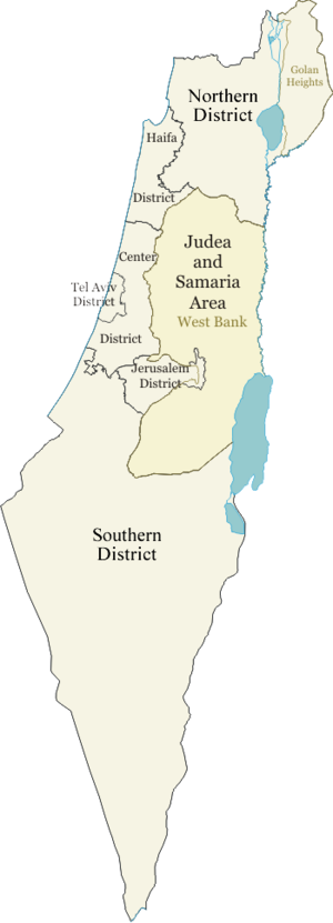
- Districts of Israel
-

 Population density by geographic region, sub-district and district (thicker border indicates higher tier).
There are six main administrative districts of Israel, known in Hebrew as mehozot (מחוזות; singular: mahoz) and fifteen sub-districts known as nafot (נפות; singular: nafa). Each sub-district is further divided into natural regions, of which there are 50.
The figures in this article are based on numbers from the Israeli Central Bureau of Statistics and so include all places under Israeli civilian rule including those Israeli-occupied territories where this is the case. Therefore, the Golan sub-district and its four natural regions are included in the number of sub-districts and natural regions even though it is not recognized by the United Nations or the vast majority of its membership as Israeli territory. Similarly, the population figure below for the Jerusalem District was calculated including East Jerusalem whose annexation by Israel is similarly widely disputed. The Judea and Samaria Area, however, is not included in the number of districts and sub-districts as Israel has not applied its civilian jurisdiction in that part of the West Bank.
Contents
Jerusalem District
Jerusalem District (Mehoz Yerushalayim). Population: 907,300
District capital: Jerusalem[1]
Northern District
Northern District (Mehoz HaTzafon). Population: 1,241,900
District capital: Nazareth
- Safed (sub-district) – population: 100,500
- Kinneret (sub-district) – population: 100,300
- Yizre'el (sub-district) – population: 444,400
- Akko (sub-district) – population: 555,300
- Golan (sub-district)[2] – population: 41,400 of which approximately half are Syrians and half are Israeli settlers.[3]
Haifa District
Haifa District (Mehoz Heifa). Population: 880,700
District capital: Haifa
- Haifa (sub-district) – population: 529,300
- Hadera (sub-district) – population: 351,400
Central District
Central District (Mehoz HaMerkaz). Population: 1,770,000
District capital: Ramla
- Sharon (sub-district) – population: 389,600
- Petah Tikva (sub-district) – population: 604,600
- Ramla (sub-district) – population: 282,800
- Rehovot (sub-district) – population: 493,000
Tel Aviv District
Tel Aviv District (Mehoz Tel Aviv). Population: 1,227,900
District capital: Tel Aviv
Southern District
Southern District (Mehoz HaDarom). Population: 1,201,200
District Capital: Beersheba
- Ashkelon (sub district) – population: 456,000
- Be'er Sheva (sub-district) – population: 565,300
Formerly Hof Aza Regional Council with a population of around 10,000 Israeli settlers was part of this district, but the settlements that constituted it were evacuated when the disengagement plan was implemented in the Gaza strip. Currently only the Coordination and Liaison Administration operates there.
Judea and Samaria Area
Judea and Samaria Area (Ezor Yehuda VeShomron). Population: 327,750 Israeli settlers (for Palestinians see Demographics of the West Bank)
Largest Israeli City: Modi'in Illit
This area is the geographical classification for Israeli settlement in the West Bank other than East Jerusalem and the former Israeli – Jordanian no man's land area near Latrun. The area has been under Israeli control since the 1967 Six-Day War but not annexed by Israel, pending negotiations regarding its status. Many Israelis consider it part of the Land of Israel, but it is not considered part of the State of Israel by any nation or the UN. See Palestinian National Authority for the Palestinian administration. Israeli Civil Administration is responsible for coordinating with the PNA.
References
- ^ This district includes areas captured in the 1967 Six-Day War and annexed to Israel in the Jerusalem Law.
- ^ Occupied in the 1967 Six-Day War and internationally unrecognized annexed by Israel's Golan Heights Law.
- ^ "Regions and territories: The Golan Heights". BBC. 10 August 2010. http://news.bbc.co.uk/2/hi/middle_east/country_profiles/3393813.stm. Retrieved 18 January 2011.
See also
- Geography of Israel
- List of cities in Israel
- ISO 3166-2:IL
External links
- Population figures for each district and sub-district
- Central Bureau of Statistics – detailed breakdown of each district, sub-district, and natural region.
- Urban Israel: Details and pictures about many cities in Israel
Districts of Israel Articles on first-level administrative divisions of Asian countries Afghanistan · Armenia · Azerbaijan1 · Bahrain · Bangladesh · Bhutan · Brunei · Burma · Cambodia · People's Republic of China · Cyprus · Egypt1 · Georgia1 · India · Indonesia1 · Iran · Iraq · Israel · Japan · Jordan · Kazakhstan1 · North Korea · South Korea · Kuwait · Kyrgyzstan · Laos · Lebanon · Malaysia · Maldives · Mongolia · Nepal · Oman · Pakistan · Palestine · Philippines · Qatar · Russia1 · Saudi Arabia · Singapore · Sri Lanka · Syria · Republic of China (Taiwan) · Tajikistan · Thailand · Timor-Leste (East Timor)1 · Turkey1 · Turkmenistan · United Arab Emirates · Uzbekistan · Vietnam · Yemen1
1 Country spanning more than one continent (transcontinental country).Categories:- Districts of Israel
- Subdivisions of Israel
- Lists of country subdivisions
- Country subdivisions of Asia
- First-level administrative country subdivisions
- Israel-related lists


Wikimedia Foundation. 2010.