- Statesville, North Carolina
-
Not to be confused with Stateville Correctional Center.
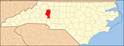
Statesville, North Carolina — City — Location of Statesville, North Carolina
Coordinates: 35°47′12″N 80°52′43″W / 35.78667°N 80.87861°WCoordinates: 35°47′12″N 80°52′43″W / 35.78667°N 80.87861°W Country United States State North Carolina County Iredell Government – Mayor Costi Kutteh Area – Total 20.6 sq mi (53.4 km2) – Land 20.5 sq mi (53.2 km2) – Water 0.1 sq mi (0.2 km2) Elevation 919 ft (280 m) Population (2010) – Total 24,633 – Density 1,195.8/sq mi (438.6/km2) Time zone Eastern (EST) (UTC-5) – Summer (DST) EDT (UTC-4) ZIP codes 28625, 28677, 28687 Area code(s) 704 FIPS code 37-64740[1] GNIS feature ID 0995438[2] Statesville is a city located in Iredell County, North Carolina, United States and was named an All-America City in 1997 and 2009. The population was 24,633 at the 2010 census. It is the county seat of Iredell County and is located at the intersection of I-40 and I-77.[3]
Contents
History
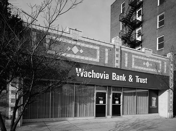
 Madison building in Statesville Commercial Historic District.
In 1753, Scots-Irish Presbyterians and German Lutherans, who originally settled in Pennsylvania, began arriving in Statesville to plant crops in the fertile soil where game and water were also plentiful. The settlement, known as Fourth Creek Congregation, was named for the fresh water stream, which was the fourth creek west of the neighboring settlement of Salisbury. The center of the settlement was a log cabin where the Presbyterians worshiped and where the First Presbyterian Church is located today.
In 1755, the colonial governor Arthur Dobbs authorized the construction of the colony’s frontier fort, which was located approximately three miles due north of the Fourth Creek settlement. Built and garrisoned by North Carolina provincial soldiers, Fort Dobbs defended the British North America’s western frontier in the colony of North Carolina during the French and Indian War. Fort Dobbs combined the functions of a military barracks, fortification, refuge for settlers, provisioning depot and center for negotiations with native Americans.
The state legislature divided Rowan County in 1788, and the new county was named Iredell for James Iredell, associate justice of the first Supreme Court during the presidency of George Washington.
One year later, the legislature selected a spot for the county seat. The Fourth Creek Congregation was chosen, and the settlement became known as Statesville.
As early as 1833, Statesville's leaders began laying track for railroads to connect the Piedmont area of North Carolina with the rest of the country.
By 1858, Statesville was growing rapidly and soon afterward began leading the state in the production of tobacco and tobacco products, the manufacture and blending of whiskey, and became a large distribution center for roots and herbs.
Points of interest
- Congregation Emanuel is one of fewer than a hundred nineteenth-century synagogue buildings still standing in the United States.
- Fort Dobbs State Historic site. The only North Carolina Historic Site associated with the French and Indian War.[4]
- Mitchell Community College. Founded as a Presbyterian women's college in 1852, Mitchell is now a public community college. In the 2008-2009 year, Mitchell became the first community college in the United States to be accepted into NASA's University Student Launch Initiative competition, and the Mitchell rocket team placed 8th out of 28 teams. In 2009-2010, Mitchell was accepted again. The 2009-2010 team's project was "The Effects of Air Ionization on the Shock-wave within a Converging-Diverging Nozzle." This team earned 4th place in the overall competition.
- Statesville was home to a minor league baseball team, Statesville Owls, from 1939 until 1963. They played in several leagues over the years including the Tar Heel League (1939–1940), North Carolina State League (1942, 1947–1952), Western Carolina League (1960–1962), and Western Carolinas League (1963). They were league champions in their respective league in 1940, 1948, and 1962.[5] The field was located at Statesville Senior High School and thus named Senior High Stadium.[6] The field is still used (all though altered over the years) by the high school's baseball team. The team which has since returned as a Summer league Collegiate Baseball team still plays at Statesville Senior High. The team's inaugural season was 2010, in which the team went 21-18 and lost in the first round of the playoffs. The team plays in the Southern Collegiate Baseball League.
- Wayside Elementary School was an elementary school located off Salisbury Road in Eastern Statesville. The current school building opened in 1941 and closed in 2002 when Wayside School and Alan D. Rutherford School merged to form Third Creek Elementary. The former Wayside building is currently home to the UAW 3520 headquarters while the former Alan D. Rutherford site is home to the Iredell-Statesville Schools Administrative Annex now known as the Alan D. Rutherford Education Building.
Demographics
As of the census[1] of 2010, there were 24,633 people, 9,338 households, and 5,957 families residing in the city. The population density was 1,195.8 people per square mile (438.6/km²). There were 10,041 housing units at an average density of 489.1 per square mile (188.8/km²). The racial composition of the city was: 59.94% White, 31.87% Black or African American, 7.11% Hispanic or Latino American, 2.71% Asian American, 0.18% Native American, 0.02% Native Hawaiian or Other Pacific Islander, 3.84% some other races, and 1.42% two or more races.
There were 9,338 households, out of which 28.1% had children under the age of 18 living with them, 41.7% were married couples living together, 17.9% had a female householder with no husband present, and 36.2% were non-families. 31.4% of all households were made up of individuals and 12.7% had someone living alone who was 65 years of age or older. The average household size was 2.39 and the average family size was 2.99.
In the city the population was spread out, with 24.4% under the age of 18, 8.7% from 18 to 24, 28.0% from 25 to 44, 21.4% from 45 to 64, and 17.4% who were 65 years of age or older. The median age was 37 years. For every 100 females there were 86.5 males. For every 100 females age 18 and over, there were 82.0 males.
The median income for a household in the city was $31,925, and the median income for a family was $41,694. Males had a median income of $31,255 versus $22,490 for females. The per capita income for the city was $19,328. About 12.7% of families and 16.1% of the population were below the poverty line, including 23.7% of those under age 18 and 13.8% of those age 65 or over.
Notable residents
- Jake Crum - NASCAR driver; 2009 Bailey's 300 Champion
- Ryan Newman - NASCAR driver
- Rockie Lynne - country music artist.
- Chris Cole - Professional Skateboarder - He currently lives in Langhorne, Pennsylvania.
- Stephen C. Reber - Archbishop of the United Episcopal Church of North America
- Vinson Smith - National Football League linebacker
- Herm Starrette- Major league baseball pitcher and coach
- Newman Ivey White - Percy Bysshe Shelley expert and American folklorist
- Mark Flake - Postmodern artist
- Danny Malboeuf - visual artist combining surrealism with other genres
- Theodore Taylor - writer (died 2006, California)
- Thomas Marshburn - NASA astronaut
- Mike Skinner - NASCAR Camping World Truck Driver
- Ian Rushton - UEFA Soccer League Goalkeeper
Notable incidents
In 27 of August 1891 passenger train derailed on a 300-foot-long (91 m) bridge, and seven cars fell down. About 30 people died in the accident.[7]
Media
The Statesville Record & Landmark is Statesville's daily newspaper, primarily serving Iredell County. It is published seven days a week.
WAME, "Country Legends 550" is an AM station at 550 kHz that plays Classic Country music.WSIC, 1400 kHz, is AM station with a news-talk format.
In addition, the signals of many stations from the Charlotte area and Piedmont Triad region reach Statesville.
References
- ^ a b "American FactFinder". United States Census Bureau. http://factfinder.census.gov. Retrieved 2008-01-31.
- ^ "US Board on Geographic Names". United States Geological Survey. 2007-10-25. http://geonames.usgs.gov. Retrieved 2008-01-31.
- ^ "Find a County". National Association of Counties. http://www.naco.org/Counties/Pages/FindACounty.aspx. Retrieved 2011-06-07.
- ^ http://www.fortdobbs.org
- ^ http://www.baseball-reference.com/bullpen/Statesville_Owls
- ^ http://futureangels.mlblogs.com/archives/2008/12/scraps_from_statesville_part_2.html
- ^ http://edition.cnn.com/2010/US/08/27/north.carolina.ghost.train/index.html#fbid=ZGflCJMCHK3&wom=true
External links
- Statesville Record & Landmark
- Official website of Statesville, NC
- Kiwanis Club of Statesvile
- Statesville Chamber of Commerce
- StatesvilleWeather.net
Charlotte Metropolitan Area Counties 
Major city Cities and towns
20k-99kConcord • Gastonia • Huntersville • Kannapolis • Matthews • Monroe • Hickory • Mooresville • Rock Hill • Salisbury • Shelby • StatesvilleCities and towns
5k-20kAlbemarle • Belmont • Bessemer City • Chester • Cherryville • Conover • Cornelius • Davidson • Fort Mill • Indian Trail • Kings Mountain • Lancaster • Lincolnton • Mint Hill • Mount Holly • South Gastonia • Unionville • Wadesboro • Weddington • YorkFootnotes Bold = principal metro cities • Italic = places and counties part of CSAMunicipalities and communities of Iredell County, North Carolina County seat: StatesvilleCity Statesville
Towns Davidson‡ | Harmony | Love Valley | Mooresville | Troutman
CDP Unincorporated
communitiesFootnotes ‡This populated place also has portions in an adjacent county or counties
Categories:- Cities in North Carolina
- Populated places in Iredell County, North Carolina
- County seats in North Carolina
- Populated places established in 1753


Wikimedia Foundation. 2010.