- Cullowhee, North Carolina
-
Cullowhee, North Carolina — CDP — Location of Cullowhee, North Carolina
Coordinates: 35°18′35″N 83°11′1″W / 35.30972°N 83.18361°WCoordinates: 35°18′35″N 83°11′1″W / 35.30972°N 83.18361°W Country United States State North Carolina County Jackson Area – Total 10.0 sq mi (16.09 km2) – Land 10.0 sq mi (16.09 km2) – Water 0.0 sq mi (0.0 km2) Elevation 2,116 ft (645 m) Population (2010) – Total 9,428 – Density 942.8/sq mi (586/km2) Time zone Eastern (EST) (UTC-5) – Summer (DST) EDT (UTC-4) ZIP code 28723 Area code(s) 828 FIPS code 37-15880[1] GNIS feature ID 1019881[2] Cullowhee is a census-designated place (CDP) in Jackson County, North Carolina, United States. Cullowhee is best known for being the home of Western Carolina University (WCU). The population was 9,428 as of the 2010 census. The area known as Cullowhee has Western Carolina University, part of the UNC System, and the village/town of Forest Hills within its area. The Jackson County Recreation Department and the Jackson County Airport are also located in the Cullowhee area.
Contents
Geography
Cullowhee is located at 35°18′35″N 83°11′01″W / 35.309704°N 83.183726°W.[3]
According to the United States Census Bureau, the CDP has a total area of 10.0 square miles (26 km2), all of it land.
Demographics
As of the census[1] of 2010, there were 9,428 people. As of the 2000 census, there were 716 households, and 272 families residing in the CDP. The population density was 983.1 people per square mile (379.6/km2). There were 823 housing units at an average density of 226.1/sq mi (87.3/km2). The racial makeup of the CDP was 88.91% White, 7.24% African American, 0.95% Native American, 1.34% Asian, 0.08% Pacific Islander, 0.53% from other races, and 0.95% from two or more races. Hispanic or Latino of any race were 1.31% of the population.
There were 716 households out of which 17.5% had children under the age of 18 living with them, 28.1% were married couples living together, 7.3% had a female householder with no husband present, and 61.9% were non-families. 35.9% of all households were made up of individuals and 5.0% had someone living alone who was 65 years of age or older. The average household size was 2.01 and the average family size was 2.72.
In the CDP the population was spread out with 5.9% under the age of 18, 72.8% from 18 to 24, 11.0% from 25 to 44, 7.0% from 45 to 64, and 3.2% who were 65 years of age or older. The median age was 21 years. Both the overall age distribution and the median age are driven by the presence of Western Carolina University. For every 100 females there were 85.2 males. For every 100 females age 18 and over, there were 84.4 males
The median income for a household in the CDP was $19,688, and the median income for a family was $36,538. However, poverty statistics that are based on surveys of the entire population can be extremely misleading in communities dominated by students, such as Cullowhee. Males had a median income of $26,161 versus $16,607 for females. The per capita income for the CDP was $10,017. About 25.2% of families and 41.5% of the population were below the poverty line, including 37.3% of those under age 18 and 9.6% of those age 65 or over.
Climate
Located in a thermal valley, Cullowhee typically enjoys a rather mild winter season. In the summer, high temperatures can reach into the 90s Fahrenheit (30s Celsius.)[4]
Education
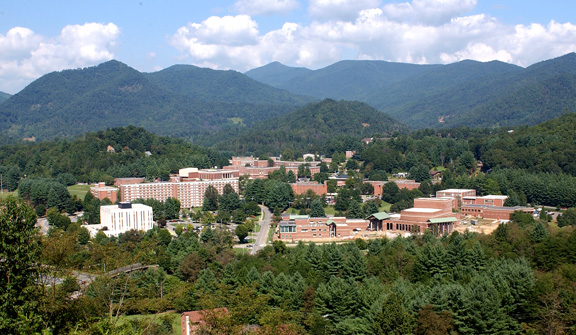
Cullowhee is home to Western Carolina University. A constituent campus of the University of North Carolina system, WCU is the fifth oldest institution in the UNC system. It was founded in 1889 with a few hundred students in a small, one story wood building and has grown to have over 9,000 students with approximately 220 majors and concentrations for undergraduates in addition to more than 40 graduate-level programs of study. The campus covers approximately 600 acres and takes up much of the Cullowhee Valley.
The town is home to one public Kindergarten-through-8th Grade School, Cullowhee Valley School, which was opened in 1994 and replaced a 30-year old structure on the University's Campus. High School Students have had to attend Smoky Mountain High School in nearby Sylva since Cullowhee High School closed in 1988.
History
 The Old Cullowhee Road area of Cullowhee in the 1920s
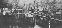
Nestled along a mountain river and in a wide valley along a creek, Cullowhee is one of the oldest settlements in Jackson County, and reportedly had the first school in the area, a one room school in 1830. The area was largely farmland, which was cleared in the 1800s. Today many farms are now wooded or have homes built on them, or college buildings. In 1883, Painter Post Office was founded by Rolling A. Painter, and located in his store. This led to the further development of the Old Cullowhee Road area into a business district. The post office was renamed Cullowhee in 1908, taking over from another post office in the vicinity of Forest Hills. In 1889, Cullowhee High School was founded by Robert Lee Madison, today's Western Carolina University. The institution ceased to be named a High School when the first brick graded school opened in 1923 with grades 1-11, now the site of the former Brown Cafeteria Building. In 1940, a massive flood caused severe damage to the business district, wiping away almost all the buildings on the side of the river opposite Western Carolina University, the North Side of the river. The buildings on the opposite side of the river survived, though waterlogged. The flood crested at 21 feet (6.4 m) above Cullowhee Dam, the highest on record. Today such a flood would be impossible due to the dams built since the flood on the East and West forks of the Tuckasegee River. When the area rebuilt, the buildings clung to the higher ground around Old Cullowhee Road and the area closer to the river was abandoned. Many of these newer buildings are today in poor shape. The area underwent massive growth starting in the 1960s and continuing through today and it will continue into the future with plans for a new University Town Center, Old Cullowhee Road revitalization, and many new homes being built or planned for the area. The oldest surviving structure in the area is St. David's in the Valley church, dating back to 1880.[5]
The town has had a public school since 1923, which has moved through four different buildings over the years. Cullowhee Valley School is the latest incarnation of this school. Before Cullowhee Valley, the public school was in Cordelia Camp Laboratory School from 1964 until 1994, McKee Training School from 1939 until 1964, and Cullowhee Training School from 1923 until 1939. The two former buildings still stand on the university campus, but the latter was demolished in the 1950s.
Most towns the size of Cullowhee have a downtown, shopping area/district, and grocery store, but Cullowhee really doesn't have any of that, as what it did have as a downtown area was washed away by the flood of 1940.
(Potential) Future of Cullowhee
 One concept of how Downtown Cullowhee could look
Forest Hills, a village/town located in the area known as Cullowhee, has had a proposal placed before it to become the town/city of Cullowhee, incorporating areas along Old Cullowhee Road and NC 107. The area around Old Cullowhee Road would then become a large traditional downtown area with mixed use buildings, a city hall, homes, walkable neighborhoods, supermarket, and trails/parks along the river and throughout the area. The Elementary School could even be relocated here, as well as the Post Office and other town/city functions. A “town center” to be constructed on some 35 acres owned by WCU is one area targeted for annexation and development as well, though it is controversial, as it may steal all business away from Old Cullowhee Road and wouldn't allow local small businesses, only chain stores and businesses. The "town center" could accommodate as much as 270,000 square feet (25,000 m2) of commercial, housing and multi-tenant office space, with parking for 871 vehicles including a 320-space parking garage on 22 acres of land owned by the university, currently home to the Cordelia Camp Outreach Center (Old Cordelia Camp Laboratory School, built in 1964), the intramural fields, and several parking lots. The annexation will also include the area that is the business district on Old Cullowhee Road (S.R. 1002) near the former campus entrance.
The Old Cullowhee Road area has declined since it was bypassed by the relocation of N.C. 107 in the late 1970s-early 1980s; CuRvE’s formation grew from a desire to rejuvenate the once-thriving commerce center. The CuRvE (Cullowhee Revitalization Endeavor) organization wants to make Cullowhee “a unique and highly attractive area – a mix of residences and businesses along rivers and streams.” CuRvE's vision is more supported by the community than the Western Carolina University "town center" vision, as CuRvE would allow small businesses, while the "town center" would not, and the Old Cullowhee Road area is along a mountain river, and many agree the site is more beautiful than the Cordelia Camp/"town center" site. [6]
Gallery
-

he Old Cullowhee Road area after the flood of 1940.
-

The Old Cullowhee School, dating from 1923.
-

The Old Speedwell General Store closed in 2009.
-

The Jackson County Recreation Department, located in the Speedwell Community of Cullowhee.
-

McKee Training School served as the local Public School from 1939 until 1964.
-

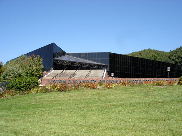
The Ramsey Center hosts many local events, as well as many of the major Western Carolina University Sports Programs. It was built in the late 1980s.
-

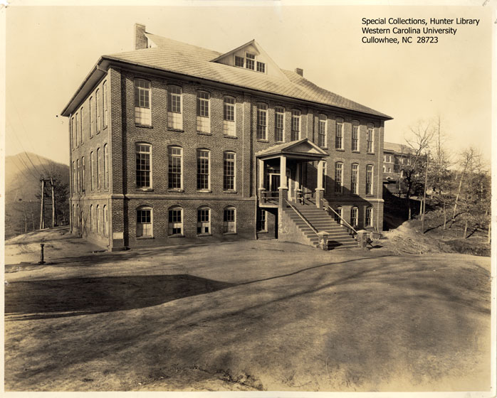
The Joyner Building was the main Western Carolina University building from 1916 until 1939.
-

Campus Apartments on Blackhawk Drive across NC 107 from the Western Carolina University Campus in Cullowhee, North Carolina. It is one of the largest apartment buildings in the area.
-

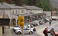
The intersection of Central Drive and Old Cullowhee Road/Old NC 107. At left is the Moss General Store, and in center background is the Old Cullowhee Road Business District.
-

The Dam at Cullowhee on the Tuckasegee River, built of concrete for electrical generation in 1930. It hasn't generated electricity since the 1960s, but instead holds back water for the county water system intake pipes.
-

The Cullowhee, North Carolina Post Office, ZIP Code 28723, located on Little Savannah Road in Cullowhee, built after NC 107 was completed to Little Savannah Road in 1977.
-

Cullowhee Valley K-8 School, located in Cullowhee, North Carolina along NC 107.
-

The new CuRvE Mural in Cullowhee, North Carolina, located along Old Cullowhee Road.
-

The new Welcome Sign for Cullowhee, North Carolina, located along Old Cullowhee Road.
-

Moss General Store on Old Cullowhee Road in Cullowhee, North Carolina, as it appeared before renovations began.
-

How the Old Cullowhee Road could look if it were revitalized.
-

One of the ideas for the transformation of Old Cullowhee Road into a downtown. This is a higher-density idea.
-

How Western Carolina University is thinking of redoing its strip of businesses, nicknamed "Downtown Cullowhee." They are also considering building a Town Center area on NC 107.
-

Billboards on Old Cullowhee Road as they appeared before being converted into a Welcome Sign and Mural.
-
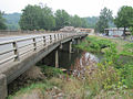
Old Cullowhee Road Bridge and Old Cullowhee as they appear today. The Bridge is scheduled to have the road deck replaced.
-

Old Cullowhee Road as it appears today. Visible are the old Village Store and Music Village Laundromat/Apartments/Shops.
-

The Western Carolina University Strip Mall in Cullowhee as it appears today, after slight upgrades made upon the purchase of the property by the University upon acquiring it in 2006.
-
The Western Carolina University Strip Mall, built in the 1950s-60s, is home to many businesses. It is nicknamed "Downtown Cullowhee," though it is far from being an actual downtown.
-

Western Carolina University and Little Savannah Road in Cullowhee, taken from the Jackson County Airport in the 1980s.
-

Western Carolina University in 2007, before work on the Quad, new dormitories, and Courtyard Cafeteria started.
-

Cullowhee as seen from the Jackson County Airport on Berry Ridge above Little Savannah Road.
Points of interest
- Tuckasegee River
- Blue Ridge Mountains
- Blue Ridge Parkway
- Great Smoky Mountains
- Eastern Cherokee Indian Reservation
- Qualla Boundary
- Dillsboro
- Great Smoky Mountains Railroad
- Nantahala Outdoor Center
- Nantahala National Forest
- Appalachian Trail
See Also
National Register of Historic Places listings in Jackson County, North Carolina
References
- ^ a b "American FactFinder". United States Census Bureau. http://factfinder.census.gov. Retrieved 2008-01-31.
- ^ "US Board on Geographic Names". United States Geological Survey. 2007-10-25. http://geonames.usgs.gov. Retrieved 2008-01-31.
- ^ "US Gazetteer files: 2010, 2000, and 1990". United States Census Bureau. 2011-02-12. http://www.census.gov/geo/www/gazetteer/gazette.html. Retrieved 2011-04-23.
- ^ (No reference)
- ^ The History of Jackson County Sesquicentennial Edition
- ^ http://www.gocullowhee.org/curve_news_7.html
External links
Municipalities and communities of Jackson County, North Carolina Towns 
Village CDPs Cashiers | Cullowhee
Unincorporated
communitiesFootnotes ‡This populated place also has portions in an adjacent county or counties
Categories:- University towns in the United States
- Populated places in Jackson County, North Carolina
- Census-designated places in North Carolina
- Western Carolina University
-


Wikimedia Foundation. 2010.