- Magnolia, Alabama
-
Magnolia, Alabama The Mask House (built c. 1861) in Magnolia Location within the state of Alabama
 Magnolia, Alabama
Coordinates: 32°8′9.49″N 87°39′34.34″W / 32.1359694°N 87.6595389°W Country United States State Alabama County Marengo Elevation 273 ft (83 m) Time zone Central (CST) (UTC-6) - Summer (DST) CDT (UTC-5) ZIP code 36754 Area code(s) 334 Magnolia is an unincorporated community in Marengo County, Alabama, United States.[1]
Geography
Magnolia is located at 32°08′09″N 87°39′34″W / 32.13597°N 87.65954°WCoordinates: 32°08′09″N 87°39′34″W / 32.13597°N 87.65954°W and has an elevation of 273 feet (83 m).[1]
References
- ^ a b ""Magnolia, Alabama"". "ePodunk Community Profiles". http://www.epodunk.com/cgi-bin/genInfo.php?locIndex=302054. Retrieved 2008-01-16.
Municipalities and communities of Marengo County, Alabama County seat: Linden Cities 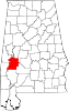
Towns Dayton | Faunsdale | Myrtlewood | Providence | Sweet Water | Thomaston
Unincorporated
communitiesAimwell | Alfalfa | Beaver Creek | Clay Hill | Consul | Coxheath | Dixons Mills | Exmoor | Half Acre | Half Chance | Hampden | Hoboken | Hugo | Jefferson | Lasca | McKinley | Magnolia | Marengo | Moores Valley | Moscow | Nanafalia | Nicholsville | Octagon | Old Spring Hill | Pin Hook | Putnam | Rembert | Salt Well | Shiloh | Siddonsville | Surginer | Vangale | Vineland | Wayne
Ghost town Aigleville
Categories:- Unincorporated communities in Alabama
- Populated places in Marengo County, Alabama
- Alabama geography stubs


Wikimedia Foundation. 2010.