- Danbury, North Carolina
-
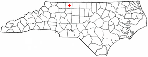
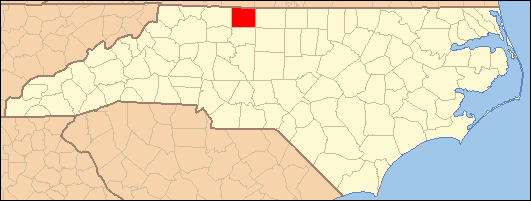
Danbury, North Carolina — Town — Stokes County Courthouse, Danbury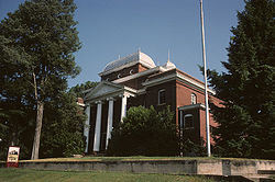 Location of Danbury, North Carolina
Coordinates: 36°24′34″N 80°12′32″W / 36.40944°N 80.20889°WCoordinates: 36°24′34″N 80°12′32″W / 36.40944°N 80.20889°W Country United States State North Carolina County Stokes Area – Total 0.6 sq mi (1.6 km2) – Land 0.6 sq mi (1.6 km2) – Water 0.0 sq mi (0.0 km2) Elevation 820 ft (250 m) Population (2000) – Total 108 – Density 170.7/sq mi (65.9/km2) Time zone Eastern (EST) (UTC-5) – Summer (DST) EDT (UTC-4) ZIP code 27016 Area code(s) 336 FIPS code 37-16240[1] GNIS feature ID 1019902[2] Website http://www.townofdanbury.org/[1] Danbury is a town located in Danbury Township, Stokes County, North Carolina. As of the 2000 census, the town had a total population of 108. It is the county seat of Stokes County. Danbury is located on NC 8/89 approximately 20 miles north of Winston-Salem and is the "Gateway to Hanging Rock". The Stokes County Government Center, Arts Council, school board, county jail, a public library, and other public services are found within the town limits. Stokes-Reynolds Memorial Hospital is located about a half mile northwest of the town.
Danbury is a popular rest stop for bicyclists, motorcyclists, and driving enthusiasts due to the numerous scenic roads in Stokes County. Danbury also attracts outdoor enthusiasts because of its location on the Dan River and near the entrance to Hanging Rock State Park.
There are no regional or national franchises in Danbury, only local shops like the Danbury General Store, and small restaurants. A 2007 edition of the Stokes News reported that Danbury will be expanding, with a small shopping center planned in the coming years.The NewBridge Bank has a branch in town. J.E.Priddy's General Store, a local historic landmark dating from the late 19th century, is still in business selling goods old and new. It is located about 2 miles east of town on Sheppard Mill Rd.
Contents
History
Danbury was founded in 1851 specifically to serve as the new centrally-located county seat after Stokes County was divided in 1849, creating Forsyth County to the south and a smaller Stokes County. Danbury was briefly known as Crawford.
No major battles occurred in Danbury during the Civil War, but it housed and supported the war efforts of the Confederate Army. The Moratock Iron Furnace, which is found in Moratock Park, was used in the smelting of iron ore. General George Stoneman's raid passed through Danbury on April 9, 1865, the day of the surrender of Confederate forces at Appomattox Court House, Va. Other historical features in the town include the Wilson Fulton House, the Old Stokes County Court House, and Moody's Tavern (later McCanless Hotel).
Geography
Danbury is located at 36°24'34" North, 80°12'32" West (36.409419, -80.208785)[3].
According to the United States Census Bureau, the town has a total area of 0.6 square miles (1.6 km2).
Demographics
As of the census[1] of 2000, there are 108 people, 47 households, and 32 families residing in the town. The population density is 170.7 people per square mile (66.2/km²). There are 53 housing units at an average density of 83.7 per square mile (32.5/km²). The racial makeup of the town is 95.37% White, 2.78% African American, 0.00% Native American, 0.00% Asian, 0.00% Pacific Islander, 0.00% from other races, and 1.85% from two or more races. 0.00% of the population are Hispanic or Latino of any race.
There are 47 households out of which 29.8% have children under the age of 18 living with them, 57.4% are married couples living together, 12.8% have a female householder with no husband present, and 29.8% are non-families. 29.8% of all households are made up of individuals and 19.1% have someone living alone who is 65 years of age or older. The average household size is 2.30 and the average family size is 2.79.
In the town the population is spread out with 22.2% under the age of 18, 4.6% from 18 to 24, 26.9% from 25 to 44, 30.6% from 45 to 64, and 15.7% who are 65 years of age or older. The median age is 44 years. For every 100 females there are 92.9 males. For every 100 females age 18 and over, there are 82.6 males.
The median income for a household in the town is $45,000, and the median income for a family is $44,688. Males have a median income of $31,250 versus $25,938 for females. The per capita income for the town is $26,053. 11.2% of the population and 9.7% of families are below the poverty line. Out of the total population, 5.3% of those under the age of 18 and 26.3% of those 65 and older are living below the poverty line.
See also
References
- ^ a b "American FactFinder". United States Census Bureau. http://factfinder.census.gov. Retrieved 2008-01-31.
- ^ "US Board on Geographic Names". United States Geological Survey. 2007-10-25. http://geonames.usgs.gov. Retrieved 2008-01-31.
- ^ "US Gazetteer files: 2010, 2000, and 1990". United States Census Bureau. 2011-02-12. http://www.census.gov/geo/www/gazetteer/gazette.html. Retrieved 2011-04-23.
External links
Municipalities and communities of Stokes County, North Carolina County seat: DanburyTowns Danbury | King‡ | Walnut Cove

Village Townships Beaver Island | Big Creek | Danbury | Meadows | Peters Creek | Quaker Gap | Sauratown | Snow Creek | Yadkin
CDPs Aarons Corner | Asbury | Boyles Chapel | Brook Cove | Brown Mountain | Campbell | Capella | Ceramic | Chestnut Grove | Collinstown | Dalton | Delta | Dillard | Dodgetown | Flat Rock | Flat Shoals | Francisco | Gap | Germanton | Hartman | Lawsonville | Meadows | Moores Springs | Mountain View | Mount Olive | Neatman | Oak Ridge | Pine Hall | Pinnacle | Poplar Springs | Prestonville | Quaker Gap | Rosebud | Sandy Ridge | Volunteer
Categories:- Populated places in Stokes County, North Carolina
- Towns in North Carolina
- County seats in North Carolina
- Populated places established in 1851

Wikimedia Foundation. 2010.