Split Rock Lighthouse State Park
- Split Rock Lighthouse State Park
Geobox|Protected area
name = Split Rock Lighthouse State Park
category = Minnesota State Park
category_iucn = V
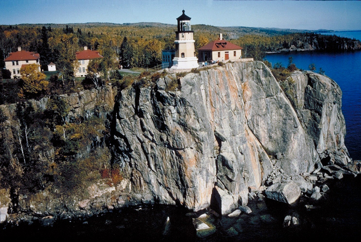
image_caption = Split Rock Lighthouse.
country = United States
country_

state = Minnesota
state_
state_type = State
region_type = County
region = Lake
city_type = City
city = Two Harbors
lat_d = 47
lat_m = 11
lat_s = 31
lat_NS = N
long_d = 91
long_m = 23
long_s = 34
long_EW = W
area_unit = acre
area_imperial = 2200
area_round = 1
established = 1945
map_locator = Minnesota

management_body = Minnesota Department of Natural Resources
Split Rock Lighthouse State Park is a Minnesota state park on the north shore of Lake Superior. It is best known for the picturesque Split Rock Lighthouse, which was built by the United States Lighthouse Service in 1910. The lighthouse and some adjacent buildings have been restored and the Minnesota Historical Society operates them as a museum. The park also offers scenic hiking, cross-country skiing, and bike trails. There is also a small campground with 22 cart-in tent sites (no vehicle access).
External links
* [http://www.dnr.state.mn.us/state_parks/split_rock_lighthouse/index.html Split Rock Lighthouse State Park website]
* [http://www.mnhs.org/places/sites/srl/ Split Rock Lighthouse State Historic Site]
* [http://www.businessnorth.com/aroundtheregion.asp?RID=1912 Split Rock Lighthouse is due for restoration]
Wikimedia Foundation.
2010.
Look at other dictionaries:
Split Rock Lighthouse State Park — Felsenküste mit dem Split Rock Lighthouse Split Rock Lighthouse State Park ist ein rund 839 Hektar großer State Park an der Küste des Oberen Sees in Minnesota. Er ist vor allem für das Split Rock Lighthouse bekannt, einen 1910 erbauten Leuchtturm … Deutsch Wikipedia
Split Rock Light — Infobox Lighthouse caption = The tower of the Split Rock Lighthouse, Summer 2004 location = Silver Bay, Minnesota coordinates = coord|47.20005|N| 91.3669|E|region:US type:landmark yearlit = 1910 automated = never yeardeactivated = 1969 foundation … Wikipedia
Charles A. Lindbergh State Park — Charles A. Lindbergh House and Park U.S. National Register of Historic Places U.S. National Historic Landmark … Wikipedia
Mille Lacs Kathio State Park — Kathio Site U.S. National Register of Historic Places U.S. National Historic Landmark District … Wikipedia
Great River Bluffs State Park — Coordinates: 43°56′47″N 91°23′58″W / 43.94639°N 91.39944°W / 43.94639; 91.39944 … Wikipedia
Forestville Mystery Cave State Park — Coordinates: 43°38′23″N 92°12′43″W / 43.63972°N 92.21194°W / 43.63972; 92.21194 … Wikipedia
Myre-Big Island State Park — Coordinates: 43°38′9″N 93°18′32″W / 43.63583°N 93.30889°W / 43.63583; 93.30889 … Wikipedia
Nerstrand-Big Woods State Park — Coordinates: 44°20′42″N 93°6′26″W / 44.345°N 93.10722°W / 44.345; 93.10722 … Wikipedia
State Parks in Minnesota — Carley State Park Flandrau Stat … Deutsch Wikipedia
Judge C. R. Magney State Park — Coordinates: 47°51′4″N 90°3′30″W / 47.85111°N 90.05833°W / 47.85111; 90.05833 … Wikipedia