- Meistratzheim
-
Meistratzheim
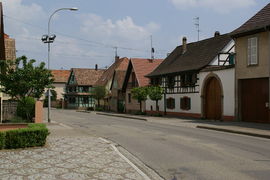
Rue Principale 
 MeistratzheimLocation within Alsace region
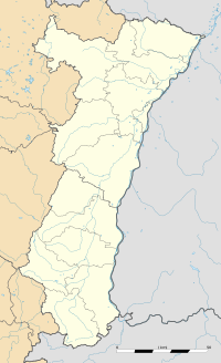 Meistratzheim
Administration Country France Region Alsace Department Bas-Rhin Arrondissement Sélestat-Erstein Canton Obernai Intercommunality Pays de Sainte-Odile Mayor André Weber
(2001–2008)Statistics Elevation 150–162 m (490–531 ft) Land area1 12.82 km2 (4.95 sq mi) Population2 1,381 (2006) - Density 108 /km2 (280 /sq mi) INSEE/Postal code 67286/ 67210 1 French Land Register data, which excludes lakes, ponds, glaciers > 1 km² (0.386 sq mi or 247 acres) and river estuaries. 2 Population without double counting: residents of multiple communes (e.g., students and military personnel) only counted once. Coordinates: 48°26′58″N 7°32′38″E / 48.449444°N 7.543888°E
Meistratzheim is a commune in the Bas-Rhin department in Alsace in north-eastern France.
Contents
History
Located near a Celtic-Romanic route connecting Belfort with Brumath, the village has been occupied since the Neolithic.[1] the village is mentioned for the first time in a parchment dating from 742 where it says that the convent of Wissembourg had possessions in Maistersheim.
Initially the village belonged to the Count of Nordgau and from 742 to 1030 to different abbeys. The fief was then acquired by the diocese of Strasbourg and later by the Landsberg family, who held it up to the French Revolution.
During the seventeenth century the village was pillaged by passing Imperial, Swedish, Lorraine and French troups. Famine came because of rigorous winters and poor harvests.
Points of interest
The catholic church, Saint André, was built from 1911 to 1919, consacrated in 1922 and is at 75 m the highest in Bas-Rhin outside of Strasbourg.
Photo gallery
-

Town Hall
-

Evangelical church
-

House facades
-

Catholic church Saint André
-

Madonna at the entrance lintel of Saint André
-

Crucifixion group at Rue de L'Eglise
-

View of the town fom Niedernai
See also
References
- ^ Pays de Sainte odile (French)
Categories:- Communes of Bas-Rhin
- Bas-Rhin geography stubs
-


Wikimedia Foundation. 2010.