- List of storms in the 2006 Atlantic hurricane season
The list of storms in the 2006 Atlantic hurricane season is a complete list of all
tropical cyclone s of the2006 Atlantic hurricane season in the Atlantic Ocean basin. The season started onJune 1 ,2006 , and officially ended onNovember 30 ,2006 . These dates conventionally delimit the period of each year when most tropical cylones form in theAtlantic basin . [cite web|author=Hurricane Resreach Division|title=FAQ Subjest G3: When is hurricane season?|year=|publisher=|accessdate=2008-04-16|url=http://www.aoml.noaa.gov/hrd/tcfaq/G1.html] The season was unusual in that no hurricanes made landfall in theUnited States of America , the first such occurrence since 2001.Hurdat One cyclone, Tropical Storm Zeta from the 2005 season, continued through early January, only the second time on record that had happened. Tropical Storm Alberto was responsible for two indirect deaths when it made landfall inFlorida . Hurricane Ernesto caused heavy rainfall inHaiti , and directly killed at least seven people in Haiti and theUnited States . Four more hurricanes formed after Ernesto, including the strongest storms of the season, Hurricanes Helene and Gordon. No tropical cyclones formed in the month of October, the first time this had happened since the 1994 season.cite web|author=National Hurricane Center |date=2006-11-01 |accessdate=2006-11-01|url=http://www.nhc.noaa.gov/archive/2006/tws/MIATWSAT_oct.shtml?|publisher=National Oceanic and Atmospheric Administration |title=Monthly Tropical Weather Summary for October 2006]Following the intense activity of the 2005 season, forecasts predicted the 2006 season would be very active, though not as active as 2005. However, in 2006, a rapidly forming
El Niño event, combined with the pervasive presence of theSaharan Air Layer over the tropical Atlantic and a steady presence of a robust secondary high related to theAzores high centered around Bermuda, contributed to a slow season and all tropical cyclone activity ceasing afterOctober 2 .cite web
author=Philip J. Klotzbach andWilliam M. Gray |date=2006-11-17
title=Summary of 2006 Atlantic Tropical Cyclone Activity and Verification of Authors' Seasonal and Monthly Forecasts | publisher=Colorado State University | accessdate=2006-11-17 | url=http://hurricane.atmos.colostate.edu/Forecasts/2006/nov2006/]Tropical Storm Zeta (2005)
Tropical Storm Zeta formed on
December 30 ,2005 and lasted untilJanuary 6 ,2006 .cite web|author=National Hurricane Center|title=Tropical Cyclone Report: Tropical Storm Zeta|publisher=NOAA|accessdate=May 1|accessyear=2006|format=PDF|url=http://www.nhc.noaa.gov/pdf/TCR-AL312005_Zeta.pdf] Although it spent most of its existence in 2006, it is officially a storm of the2005 Atlantic hurricane season since it formed during 2005. Zeta joinedHurricane Alice as only the second Atlantic tropical cyclone in recorded history to exist during two different calendar years.cite web|author=National Hurricane Center|title=Tropical Cyclone Report: Tropical Storm Zeta|publisher=NOAA|accessdate=May 1|accessyear=2006|format=PDF|url=http://www.nhc.noaa.gov/pdf/TCR-AL312005_Zeta.pdf]Tropical Storm Alberto
Infobox Hurricane Small
Basin=Atl
Track=Alberto 2006 track.pngJune 10
Dissipated=June 14
1-min winds=60
Pressure=995June 10 , an area of disturbed weather associated with a broad low pressure area off the coast ofBelize organized over the warm waters of theCaribbean Sea . The low further developed, and became the first tropical depression of the season. Southwesterly vertical wind shear was a constant companion to the system, but as it moved closer toFlorida , the depression strengthened into a tropical storm on the morning ofJune 11 . Passing over the warm, deep water of theLoop Current allowed accelerated development, and the cyclone reached its peak winds of 70 mph (115 km/h), just shy of hurricane strength. Subsequent weakening occurred as it moved over the cooler waters of thecontinental shelf .cite web|author=Lixion Avila & Daniel Brown|year=2006|title=Tropical Storm Alberto Tropical Cyclone Report|publisher=National Hurricane Center|accessdate=2007-05-10|url=http://www.nhc.noaa.gov/pdf/TCR-AL012006_Alberto.pdf|format=PDF]Alberto made landfall midday on
June 13 , about 50 miles (85 km) southeast ofTallahassee, Florida , with windspeeds of approximately convert|45|mph|km/h|abbr=on.cite web|author=National Hurricane Center|title=Tropical Storm Alberto Update, 12:45 p.m. EDT,June 13 2006|publisher=National Oceanic and Atmospheric Administration |accessdate=2006-06-13|url=http://www.nhc.noaa.gov/text/refresh/MIATCUAT1+shtml/] Alberto brought astorm surge of five feet to the Big Bend area of the Florida coastline, flooding areas of Cedar Key and Crystal River. The large system was slow to weaken, moving across Georgia andthe Carolinas before being downgraded to a tropical depression early onJune 14 . Alberto became anextratropical storm that morning while quickly moving towards the coast. As an extratropical storm, Alberto strengthened rapidly offshore New England and the Canadian Maritimes, becoming an oceanic storm by the afternoon ofJune 15 .cite web|author=National Hurricane Center|title=Tropical Storm Alberto Final Public Advisory #18, 11 a.m. EDT,June 14 2006|publisher=National Oceanic and Atmospheric Administration |accessdate=2006-06-14|url=http://www.nhc.noaa.gov/text/refresh/MIATCPAT1+shtml/] cite web|author=National Hurricane Center|title=Tropical Storm Alberto Coastal Watches/Warnings and 5-Day Cone, 11 a.m. EDT,June 14 2006|publisher=National Oceanic and Atmospheric Administration |accessdate=2006-06-14|url=http://www.nhc.noaa.gov/refresh/graphics_at1+shtml/144546.shtml?5day] Damage in theUnited States totaled to $420,000 (2006 USD), and one indirect death occurred. [cite web|author=National Climatic Data Center|accessdate=2008-04-24|year=2006|title=Event Report for Florida|url=http://www4.ncdc.noaa.gov/cgi-win/wwcgi.dll?wwevent~ShowEvent~607440] [cite web|author=National Climatic Data Center|accessdate=2008-04-24|year=2006|title=Event Report for Florida (2)|url=http://www4.ncdc.noaa.gov/cgi-win/wwcgi.dll?wwevent~ShowEvent~607443]Unnamed Tropical Storm
Infobox Hurricane Small
Basin=Atl
Track=2006 Atlantic tropical storm 2 track.pngJuly 17
Dissipated=July 18
1-min winds=45
Pressure=998Gulf Stream onJuly 17 , south ofNantucket Island . It was briefly a tropical storm before becoming a remnant low onJuly 18 southeast ofNova Scotia . It crossed overAtlantic Canada with rain and wind, but no damage or fatalities were reported. Had it been discovered operationally, it would have been named Tropical Storm Beryl.Cite web|author=National Hurricane Center|title=Unnamed Tropical Storm Tropical Cyclone Report|year=2006|publisher=National Hurricane Center|accessdate=2008-03-07|url=http://www.nhc.noaa.gov/pdf/TCR-AL502006_Unnamed.pdf] It dissipated northeast ofCape Race , Newfoundland. As the storm entered the area of responsibility of theCanadian Hurricane Centre , abuoy recorded sustained winds of 36 mph (56 km/h) with gusts up to 44 mph (70 km/h). [cite web|author=Canadian Hurricane Centre|year=2007|title=2006 Atlantic Hurricane Season Review|accessdate=2008-04-24|url=http://www.atl.ec.gc.ca/weather/hurricane/storm06.html]Tropical Storm Beryl
Infobox Hurricane Small
Basin=Atl
Track=Beryl 2006 track.pngJuly 18
Dissipated=July 21
1-min winds=50
Pressure=1000North Carolina coast. On the morning ofJuly 18 , the low pressure area was designated the second tropical cyclone of the season. That afternoon, the depression was upgraded to Tropical Storm Beryl.cite web | author = National Hurricane Center | title = Tropical Storm Beryl Tropical Cyclone Update, 4:55 p.m. EDT,July 18 2006 | date =July 18 ,2006 | accessdate = 2006-07-18|publisher =Florida State University Meteorology Department | url = ftp://ftp.met.fsu.edu/pub/weather/tropical/WTNT6/2006071820.WTNT62]Beryl continued moving to the north until it turned to the northeast on
July 20 . Beryl paralleled theEast Coast of the United States and made landfall onNantucket island before becoming extratropical southwest ofNova Scotia onJuly 21 . The storm caused high waves along theEast Coast of the United States , with 19 feet seas (5.97 m) in the open ocean. [http://www.boston.com/news/globe/city_region/breaking_news/2006/07/tropical_storm_2.html Local News Updates - Tropical Storm Beryl fizzles as it passes over Nantucket -The Boston Globe ] ] Waves along the southern coast ofNantucket reached convert|10|ft|m in height as the storm approached the island,cite web|author=NASA/GOES Project Office|year=2006|title=Beryl's Effect on Nantucket Island, Mass|accessdate=2007-05-22|url=http://www.nasa.gov/mission_pages/hurricanes/archives/2006/h2006_beryl.html] resulting in four people being rescued by lifeguards from rip currents.cite web|author=Carolyn Johnson and Yuxing Zheng|year=2006|title=Tropical Storm Beryl sweeps into region|publisher=Boston Globe|accessdate=2007-05-22|url=http://www.boston.com/news/local/massachusetts/articles/2006/07/21/tropical_storm_beryl_sweeps_into_region/]Tropical Storm Chris
Infobox Hurricane Small
Basin=Atl
Track=Chris 2006 track.pngJuly 31
Dissipated=August 5
1-min winds=55
Pressure=1001July 26 , a vigorous tropical wave emerged off the coast ofAfrica and slowly tracked westward. It slowly developed due to poor environmental conditions and it became a tropical depression late onJuly 31 about 160 miles (260 km) east ofAntigua . [cite web|author=National Hurricane Center|title=Discussion for Tropical Depression Three, 11:00 p.m. EDT,July 31 2006|publisher=NOAA|accessmonthday=1 August |accessyear=2006|url=http://www.nhc.noaa.gov/archive/2006/al03/al032006.discus.001.shtml?] The depression soon strengthened further and was named Tropical Storm Chris six hours later. [cite web|author=National Hurricane Center|title=Discussion for Tropical Depression Three, 5:00 a.m. EDT,August 1 2006|publisher=NOAA|accessmonthday=1 August |accessyear=2006|url=http://www.nhc.noaa.gov/archive/2006/al03/al032006.discus.002.shtml?]National Hurricane Center forecasters dismissed some computer models, which dissipated Chris quickly, as they did not have a handle on the strength of the storm.cite web|author=National Hurricane Center|title=Discussion for Tropical Depression Three, 11:00 a.m. EDT,August 1 2006|publisher=NOAA|accessmonthday=1 August |accessyear=2006|url=http://www.nhc.noaa.gov/archive/2006/al03/al032006.discus.003.shtml?] Tropical Storm Chris moved to the northwest and gradually strengthened before reaching its peak strength onAugust 2 with winds of 65 mph (100 km/h), when it was to the northeast of theUnited States Virgin Islands .cite web|author=National Hurricane Center|title=Discussion for Tropical Storm Chris, 11:00 a.m. EDT,August 2 2005|publisher=NOAA|accessmonthday=5 August |accessyear=2006|url=http://www.nhc.noaa.gov/archive/2006/al03/al032006.discus.008.shtml?] The storm was forecast to strengthen further and become a hurricane as it moved into theBahamas . However, Chris began to be affected by wind shear and became disorganized. The storm weakened to a tropical depression onAugust 4 , and dissipated as it approached theCuba n coast.Cite web|author=Stacy R. Stewart|title=Tropical Storm Chris Tropical Cyclone Report|publisher=National Hurricane Center|accessdate=2008-04-23|url=http://www.nhc.noaa.gov/pdf/TCR-AL032006_Chris.pdf]Cruise lines such as
Royal Caribbean re-routed their ships to avoid the storm. [cite web|author=Royal Caribbean|title=Tropical Weather Update forAugust 2 2006|accessdate=2 August |url=http://www.royalcaribbean.com/contentPage.do;jsessionid=0000ZpYZCuMqnhT6dS0NHdrM_pt:10ktdmlju?pagename=important_updates] InPuerto Rico , rainfall from the storm caused the Fajardo River to overflow its banks. The overflown waters temporarily closed a highway in the northeastern portion of the island. Rainfall reached up to 2inches (50 mm) across portions ofHispaniola , theTurks and Caicos , theBahamas , and easternCuba , and reached 4 inches (100 mm) in some mountainous areas.Tropical Storm Debby
Infobox Hurricane Small
Basin=Atl
Track=Debby 2006 track.pngAugust 21
Dissipated=August 26
1-min winds=45
Pressure=999August 20 atropical wave emerged off the coast of Africa for the Atlantic Ocean. Immediately following, the wave developed convective banding and a broad circulation. At 1800 UTC onAugust 21 , a tropical depression formed to the south-southeast of theCape Verde Islands .cite web|author=James Franklin|title=Tropical Cyclone Report: Tropical Storm Debby|year=2006|publisher=National Hurricane Center|accessdate=2008-06-06|url=http://www.nhc.noaa.gov/pdf/TCR-AL042006_Debby.pdf] Despite an increase in inner-core convection, the depression was a large, well-organized system.cite web|author=Stewart|title=Tropical Depression Four Discussion Number 2|year=2006|publisher=National Hurricane Center|accessdate=2008-06-06|url=http://www.nhc.noaa.gov/archive/2006/al04/al042006.discus.002.shtml?] Tracking west-northwestward south of a subtropical ridge, late onAugust 22 , sufficient organization had developed for the National Hurricane Center to upgrade to storm to Tropical Storm Debby, despite convective cloud top warming. [cite web|author=Stewart|title=Tropical Storm Debby Discussion Number 6|year=2006|publisher=National Hurricane Center|accessdate=2008-06-06|url=http://www.nhc.noaa.gov/archive/2006/al04/al042006.discus.006.shtml?]Later that day the storm reached its peak with winds of convert|50|mph|km/h|abbr=on, and persisted at that strength for about two days. However, Debby subsequently entered a dry and stable air mass and deteriorated in organization, which supressed further intensification. [cite web|author=Franklin|title=Tropical Storm Debby Dsicussion Number 9|year=2006|publisher=National Hurricane Center|accessdate=2008-06-06|url=http://www.nhc.noaa.gov/archive/2006/al04/al042006.discus.009.shtml?] In association with an upper-level trough, southerly
wind shear increased and displaced the convection to the north of the center. The cyclone began to weaken, and by 0600 UTC onAugust 26 , it was downgraded to a depression. The next day, the system dissipated, and the last advisory was issued on the storm. [cite web|author=Roberts & Pasch|title=Tropical Depression Debby Discussion Number 25|year=2006|publisher=National Hurricane Center|accessdate=2008-06-06|url=http://www.nhc.noaa.gov/archive/2006/al04/al042006.discus.025.shtml?]Hurricane Ernesto
Infobox Hurricane Small
Basin=Atl
Track=Ernesto 2006 track.pngAugust 24
Dissipated=September 1
1-min winds=65
Pressure=985August 24 , a reconnaissance flight determined that a tropical wave passing through theWindward Islands had developed a closed tropical circulation, and advisories were commenced on Tropical Depression Five. By 5 p.m. EDT (2100 UTC) onAugust 25 , a second flight had found sustained tropical-storm force winds, and the system was named Ernesto. Ernesto became a hurricane on the morning ofAugust 27 just south ofHaiti , before it was downgraded back to a tropical storm in the afternoon. The storm caused five deaths in Haiti due to rainfall.Cite web|author=Richard D. Knabb and Michelle Mainelli|title=Hurricane Ernesto Tropical Cyclone Report|year=2006|publisher=National Hurricane Center|accessdate=2008-04-23|url=http://www.nhc.noaa.gov/pdf/TCR-AL052006_Ernesto.pdf]Ernesto made landfall near Guantanamo Bay,
Cuba , early in the morning onAugust 28 . At one point the storm was predicted to become a major hurricane in theGulf of Mexico and threaten parts of theGulf Coast . However, Ernesto moved much farther east than anticipated, and made landfall as a tropical storm on the southern tip ofFlorida onAugust 29 . Two people died in Florida in road traffic accidents attributed to the weather conditions, as the cyclone slowly moved northward across the southern half of the peninsula. Ernesto regained tropical storm strength as it crossed Florida and emerged from land nearCape Canaveral , and was just below hurricane strength when it made landfall again inNorth Carolina onAugust 31 .Cite web|author=Richard D. Knabb and Michelle Mainelli|title=Hurricane Ernesto Tropical Cyclone Report|year=2006|publisher=National Hurricane Center|accessdate=2008-04-23|url=http://www.nhc.noaa.gov/pdf/TCR-AL052006_Ernesto.pdf]Damage in Virginia totaled to $104 million (2006
USD ),"WAVY " [http://www.wavy.com/Global/story.asp?S=5384483 Kaine seeks disaster declaration for 25 localities] URL Accessed:September 11 ,2006 ] and in total the storm caused about $500 million (2006 USD) in damage. [cite web|author=AVILA/BEVEN/FRANKLIN/KNABB/PASCH/STEWART/BLAKE/BROWN/MAINELLI/RHOME|title=Monthly Tropical Weather Summary|year=2006|publisher=National Hurricane Center|accessdate=2008-04-17|url=ftp://ftp.met.fsu.edu/pub/weather/tropical/Monthly/2006120114.ABNT30] The storm, while extratropical, moved over SouthernOntario and dissipated over the St. Lawrence river area inQuebec .Hurricane Florence
Infobox Hurricane Small
Basin=Atl
Track=Florence 2006 track.pngSeptember 3
Dissipated=September 12
1-min winds=80
Pressure=974Africa and theLesser Antilles onSeptember 3 .cite web|author=Jack Beven|year=2006|title=Hurricane Florence Tropical Cyclone Report|publisher=National Hurricane Center|accessdate=2007-06-06|url=http://www.nhc.noaa.gov/pdf/TCR-AL062006_Florence.pdf] Initial strengthening of the depression was slow due to shearing wind conditions. Despite the moderate to highwind shear , it strengthened enough to become Tropical Storm Florence on the morning ofSeptember 5 . After becoming a tropical storm, Florence's wind field began to expand greatly; at one point tropical storm-force winds extended outward up to convert|450|mi|km from the center. With a disorganized structure and multiple circulation centers, Florence remained a weak tropical storm for several days, even after external conditions became favorable for strengthening. Around the evening ofSeptember 8 it resolved to a single center and steady strengthening resumed. [cite web|author=National Hurricane Center|title=Discussion for Tropical Storm Florence, 11:00 a.m. EDT, Sept. 8, 2006|publisher=NOAA|accessdate=2006-09-09|url=http://www.nhc.noaa.gov/archive/2006/al06/al062006.discus.020.shtml] On the morning ofSeptember 10 , Florence reached hurricane strength.Large swells, rip tide, andundertow were reported on Bermuda, theLeeward Islands , theVirgin Islands , andHispaniola . [cite news|author=Associated Press|publisher=CNN|title=Bermuda braces as Florence becomes hurricane|url=http://www.cnn.com/2006/WEATHER/09/10/tropical.weather/] Florence soon reached its peak as a Category 1 hurricane very nearBermuda , and became extratropical onSeptember 12 , while still a hurricane.Hurricane Gordon
Infobox Hurricane Small
Basin=Atl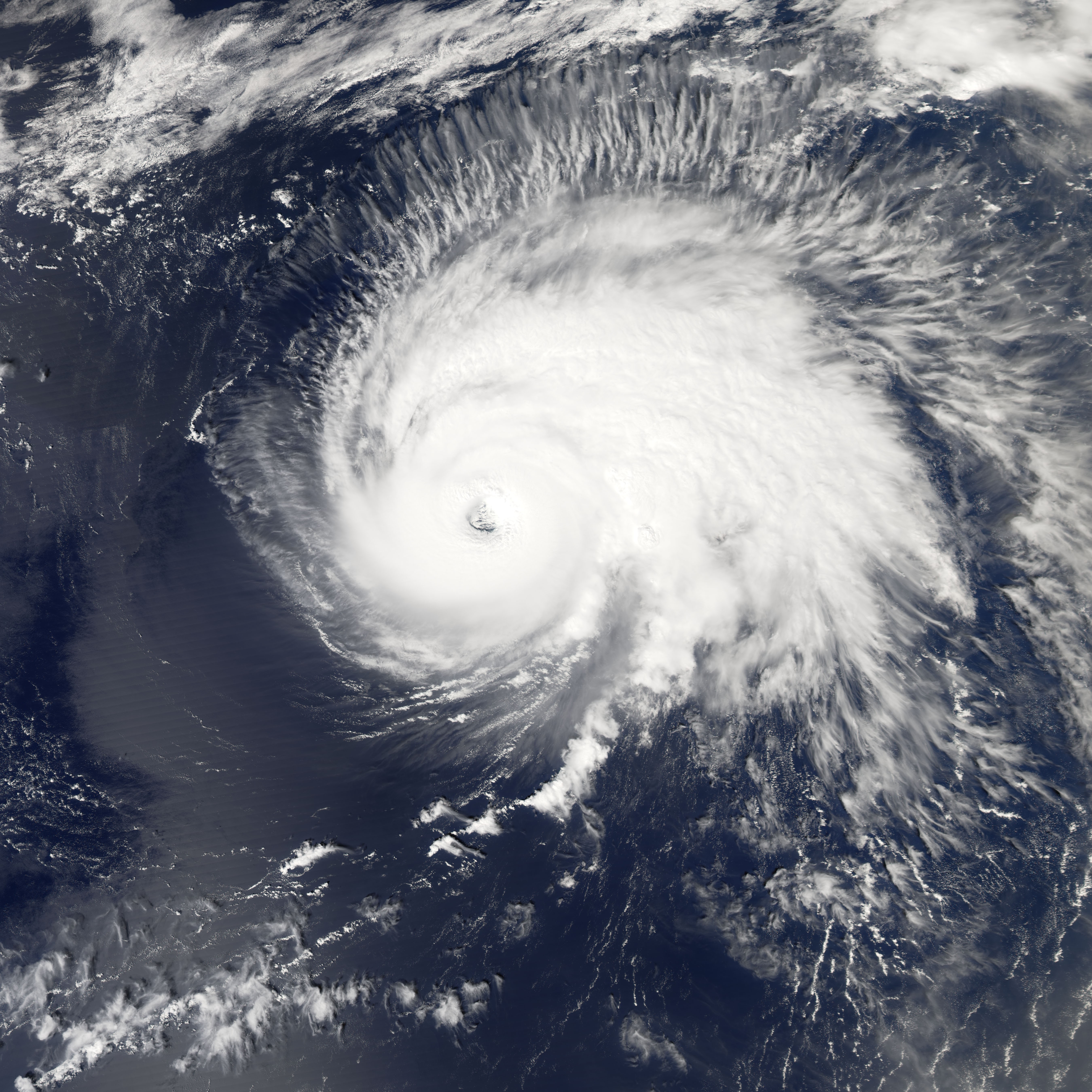
Track=Gordon 2006 track.pngSeptember 11
Dissipated=September 20
1-min winds=105
Pressure=955September 1 , a low-pressure system gradually became organized northeast of theLesser Antilles . On the evening ofSeptember 10 , it developed a closed circulation and was declared Tropical Depression Seven. It continued to intensify, and strengthened into Tropical Storm Gordon onSeptember 11 and Hurricane Gordon late onSeptember 12 . Gordon attained Category 2 status on the evening ofSeptember 13 , and was further upgraded to Category 3 status that same night, making it the first major hurricane of the season.Cite web|author=Eric Blake|title=Hurricane Gordon Tropical Cyclone Report|year=2006|publisher=National Hurricane Center|accessdate=2008-03-07|url=http://www.nhc.noaa.gov/pdf/TCR-AL072006_Gordon.pdf]Around
September 16 it was nearly stationary for some time in the mid-Atlantic about 1000 miles east ofBermuda , and weakened to be barely a hurricane.Cite web|author=Brennan/Knabb|title=Hurricane Gordon Discussion Number 22|year=2006|publisher=National Hurricane Center|accessdate=2008-03-07|url=http://www.nhc.noaa.gov/archive/2006/al07/al072006.discus.022.shtml?] However, as it subsequently accelerated eastwards, it restrengthened to Category 2. OnSeptember 19 hurricane warnings were issued for theAzores , as the predicted path passed through the center of thatarchipelago . It became extratropical onSeptember 20 after passing through Azorean waters, but the remnants side-swiped north-westernSpain and then moved rapidly north towardsIreland and the west of Britain onSeptember 21 . By the morning ofSeptember 22 , it had become absorbed into a large Atlantic low to the west of Ireland.Cite web|author=Eric Blake|title=Hurricane Gordon Tropical Cyclone Report|year=2006|publisher=National Hurricane Center|accessdate=2008-03-07|url=http://www.nhc.noaa.gov/pdf/TCR-AL072006_Gordon.pdf]Although there were no reports of fatalities from Gordon, when it sideswiped the
Azores , it produced high winds and heavy rainfall causing minor damage limited to fallen trees and powerlines. During the extratropical stages of the storm's exsistance, it brought high wind toSpain causing four injuries and leaving 100,000 people without electric power. InNorthern Ireland , 126,000 homes were left without power, and one injury occurred. In addition, the strong extratropical storm produced high winds and rain, which affected practice rounds at theRyder Cup golf tournament in Ireland.cite web|author=BBC news|title=Thousands still without power|year=2006|publisher=|accessdate=2008-01-26|url=http://news.bbc.co.uk/2/hi/uk_news/northern_ireland/5371984.stm]Hurricane Helene
Infobox Hurricane Small
Basin=Atl
Track=Helene 2006 track.pngSeptember 12
Dissipated=September 24
1-min winds=105
Pressure=955September 11 , atropical wave moved off the coast ofAfrica . It quickly organized, and onSeptember 12 was declared Tropical Depression Eight. It developed broad low pressure system as it passed south of theCape Verde Islands s. Easterlywind shear initially slowed intensification, although onSeptember 13 , convective banding increased over the northern semi-circle. Continuing to organize, it reached tropical storm strength onSeptember 14 , becoming a hurricane onSeptember 16 . Helene tracked northwestward and slowed down, due to a weakness in the ridge created by Hurricane Gordon. The storm attained major hurricane status onSeptember 17 . It moved generally west-northwestward before commencing a northeasterly turn. Large currents from Helene lashedBermuda . It became fully extratropical onSeptember 24 . The extratropical storm dissipated over Ireland.cite web | author=Brown, Daniel P. | date=November 15 ,2006 | title=Tropical Cyclone Report: Hurricane Helene | publisher=National Hurricane Center | accessdate=2006-11-15 | url=http://www.nhc.noaa.gov/pdf/TCR-AL082006_Helene.pdf]Hurricane Isaac
Infobox Hurricane Small
Basin=Atl
Track=Isaac 2006 track.pngSeptember 27
Dissipated=October 2
1-min winds=75
Pressure=985September 27 , and a tropical storm bySeptember 28 . By that time it was about 810 miles east-southeast ofBermuda . It became a hurricane onSeptember 30 , and passed about 280 miles (450 km) east of Bermuda before swinging northwards towards Newfoundland. As it was still a strong tropical storm near theAvalon Peninsula , tropical storm warnings were issued onOctober 2 due to the potential for high winds. Isaac passed 45 km (30 miles) to the southeast ofCape Race late that afternoon.Cite web|author=Michelle Mainelli|title=Hurricane Isaac Tropical Cyclone Report|year=2006|publisher=National Hurricane Center|accessdate=2008-04-26|url=http://www.nhc.noaa.gov/pdf/TCR-AL092006_Isaac.pdf] TheCanadian Hurricane Centre reports that if Isaac had tracked just 50 to 100 km (30 to 60 miles) farther north than it did, the St. John's area would have experienced much higher winds than the peak gust of 54 km/h (34 mph) it received.cite web|author=Canadian Hurricane Center|title=Hurricane Isaac Post-Tropical Storm Information Statement|year=2006|publisher=|accessdate=2008-04-16|url=http://www.atl.ec.gc.ca/weather/hurricane/bulletins/20061003022851.Isaac.txt.en]At its closest approach to the Avalon Peninsula, Isaac was still tropical, and had maximum sustained winds of convert|50|kn and a minimum central pressure of 993
mbar . Strongest winds on land in Newfoundland were reported at Cape Race, where a maximum gust to 96 km/h (60 mph) with a sustained wind of 74 km/h (46 mph) was recorded. At Cape Pine, a peak wind was reported at 76 km/h (47 mph). However, due to Isaac's small size and fast forward speed, winds were lighter over most of the Avalon Peninsula.Rainfall from Isaac was not reported to be higher than 25 mm (0.98 inches) in most areas due to Isaac's speed and decreasing amount of moisture. The highest measured amount was 26 mm (1.02 inch) at Cape Race, while Cape Pine reported 19 mm (0.75 inches) and St. John's reported less than 10 mm (0.39 inches).References
Wikimedia Foundation. 2010.