Friarton Bridge

Friarton Bridge

Infobox_Bridge
bridge_name = Friarton Bridge
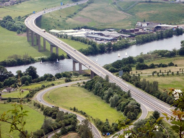


caption = Friarton Bridge, viewed from Kinnoull Hill
official_name =
carries = M90
crosses = River Tay
locale = Perth, Scotland
maint =
id =
design = Segmental
mainspan = convert|570|ft|m|0
length =
width =
height =
clearance =
below =
traffic =
open = 1974
closed =
toll =
map_cue =
map_

map_text =
map_width =
coordinates = Coord|56|22|44.2|N|3|24|33.6|W|type:landmark
lat=
long=

The Friarton Bridge is a road bridge across the Firth of Tay in Perth , Scotland. It is situated on the southeastern outskirts of Perth, approximately 25 miles upstream of the Tay Road Bridge. It is part of the M90 motorway, and is one of the northernmost sections of motorway in the United Kingdom. It forms part of the important east coast road corridor from Edinburgh to Dundee and Aberdeen.

The bridge spans the river, a row of electricity pylons, the Dundee-Perth railway line, a number of warehouses and the A85 high above the surrounding plain.

It is a two-lane dual carriageway; unusually for a motorway (although not unusually for the M90) neither carriageway has a hard shoulder. It was built in 1978, when it was designated as the M85 motorway. When the A85 from the north end of the bridge to Dundee was renumbered in the early 1990s to A90 through to Dundee, the motorway's designation changed to M90 to provide a continuous route number from Edinburgh to Fraserburgh.

Gallery

References

* [http://ntlsearch.bts.gov/tris/record/tris/00745882.html TRIS Online: M90 Friarton Bridge Improvements]


Wikimedia Foundation. 2010.

Игры ⚽ Нужно сделать НИР?

Look at other dictionaries:

  • Perth, Scotland — Coordinates: 56°23′49″N 3°26′14″W / 56.396911°N 3.437262°W / 56.396911; 3.437262 …   Wikipedia

  • List of bridges in the United Kingdom — Bridges in the United Kingdom is a link page for any non railway bridge in the United Kingdom.Railway bridges are listed under: List of railway bridges and viaducts in the United Kingdom.England*Bridge of Sighs (Cambridge) *Bridge of Sighs… …   Wikipedia

  • Perth (Schottland) — Perth Koordinaten 56° 24′ N, 3° 27′ W …   Deutsch Wikipedia

  • Motorway M90 — Vorlage:Infobox hochrangige Straße/Wartung/GB M M90 motorway im Vereinigten Königreich …   Deutsch Wikipedia

  • M90 motorway — UK motorway routebox motorway= M90 length mi= 30 length km= 48 direction= South North start= Inverkeithing near Forth Road Bridge destinations= None end= Perth (two ends; one east, one at Broxden Junction) opening date= 1964 completion date=1978… …   Wikipedia

  • Kinnoull Hill — Infobox Mountain Name = Kinnoull Hill Photo = 008703 a7484d0b.jpg Caption = Kinnoull Hill s tower, with the meandering River Tay in the background Elevation = convert|222.2|m|ft|0|lk=on Location = Perth, Perth and Kinross, Scotland Range =… …   Wikipedia

  • European windstorm — Satellite picture of a European windstorm A European windstorm is a severe cyclonic windstorm associated with areas of low atmospheric pressure that track across the North Atlantic towards northwestern Europe. They are most common in the winter… …   Wikipedia

Share the article and excerpts

Direct link
Do a right-click on the link above
and select “Copy Link”