Cunduacán

Cunduacán
Cunduacán
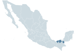
Location within Mexico
Location within Tabasco
Coordinates: 18°4′0″N 93°10′0″W / 18.066667°N 93.166667°W / 18.066667; -93.166667Coordinates: 18°4′0″N 93°10′0″W / 18.066667°N 93.166667°W / 18.066667; -93.166667
Country Mexico
State Tabasco
Municipality
Founded
Government
 – Municipal delegate
Time zone Central Standard Time

Cunduacán is a municipality in the central portion of the state of Tabasco, in Mexico. It is located at about 18°4'0"North, 93°10'0"West.

It is located in the Grijalva River Region, Chontalpa subregion. Its name originates from the Mayan cum-ua-cán, which means "place of corn and serpents", which is also the name of the city which is the municipal seat of the municipality. It is made up of 10 villages, 31 ranches (rancherías), 59 ejidos and 13 colonias. The town had a 2005 census population of 81,392 inhabitants (the sixth-largest community in the state after Villahermosa, Cárdenas, and Comalcalco, Huimangillo, and Macuspana), while the municipality had a population of 112,036 (www.inegi.gob.mx). The municipality has an area of 1,017 km² (392.7 sq mi), the 8th in the state in terms of geographical coverage and corresponding to 2.54% of the total area of the state. To the North are the municipalities of Comalcalco and Jalpa de Méndez, to the East are the municipalities of Nacajuca and Centro, to the South is the municipality of Centro and the State of Chiapas, and to the West is the municipality of Cárdenas. Geophysically the municipality is completely flat, as it is part of the coastal plain. Its hydrography consists of the rivers Mezcalapa, which marks its southern border with the municipalities of Centro, Samaria, Guayabal, Cucuyulapa, Barí, Cunduacán and Tular; and the lagoons of Cucuyulapa and Ballona. The state's Universidad Juarez Autonoma de Tabasco has various centers in Cunduacán.

External links


Wikimedia Foundation. 2010.

Игры ⚽ Поможем решить контрольную работу

Look at other dictionaries:

  • Cunduacán — Saltar a navegación, búsqueda Municipio de Cunduacán Escudo …   Wikipedia Español

  • Cunduacán — es un municipio del estado mexicano de Tabasco, localizado en la región del río Grijalva y en la subregión de la Chontalpa. Su cabecera municipal es la ciudad de Cunduacán y cuenta con una división constituida, además, por 10 poblados, 31… …   Enciclopedia Universal

  • Cunduacan — Original name in latin Cunduacn Name in other language Conduacan, Conduacn, Cunduacan, Cunduacn State code MX Continent/City America/Mexico City longitude 18.06562 latitude 93.17698 altitude 18 Population 17904 Date 2012 09 06 …   Cities with a population over 1000 database

  • Cunduacan — Admin ASC 2 Code Orig. name Cunduacán Country and Admin Code MX.27.006 MX …   World countries Adminstrative division ASC I-II

  • Cunduacán Municipality — Cunduacán (municipality)   Municipality   Location of the municipality in Tabasco. Country …   Wikipedia

  • Tabasco — Para otros usos de este término, véase Tabasco (desambiguación). Estado Libre y Soberano de Tabasco Estado de México …   Wikipedia Español

  • Intervención francesa en Tabasco — Retirada de las fuerzas invasoras francesas de San Juan Bautista, capital de Tabasco, el 27 de febrero de 1864. Fecha …   Wikipedia Español

  • Historia de Tabasco — Artículos Relacionados Época Precolombina Mesoamérica Culltura Olmeca La Venta Cultura maya Maya Putunes …   Wikipedia Español

  • Gregorio Méndez Magaña — Gobernador de Tabasco 4 de octubre de 1864 – 6 de junio de 1887 Predecesor …   Wikipedia Español

  • Turismo en Tabasco — El estado de Tabasco, ubicado en el sureste de México, es una cálida planicie del trópico húmedo cruzado por caudalosos ríos salpicada por lagunas, pantanos, costas y una exuberante vegetación. Por su ubicación estratégica, Tabasco es considerado …   Wikipedia Español

Share the article and excerpts

Direct link
Do a right-click on the link above
and select “Copy Link”