- D'Entrecasteaux Islands
-
 D'Entrecasteaux Islands
D'Entrecasteaux Islands (
 /ˌdɒntrəkæˈstoʊ/; French: [dɑ̃ .tʁə.ka.sto]) are situated near the eastern tip of New Guinea in the Solomon Sea in Milne Bay Province of Papua New Guinea. The group spans a distance of 160 km, has a total land area of approximately 3,100 km² and is separated from the Papua New Guinea mainland by the 30 km wide Ward Hunt Strait in the north and the 18 km wide Goschen Strait in the south. D'Entrecasteaux Islands show signs of volcanism.
Contents
People
The inhabitants of D'Entrecasteaux Islands are indigenous subsistence horticulturalists living in small, traditional settlements. People of this area produced and traded clay pots as well as participated in the Kula exchange of shell valuables, travelling widely to other islands on sea-going sailing canoes. During the more recent past, people harvested copra, trochus and pearlshells and some timber for cash. Alluvial gold mining was once important and in recent years the area has been subject to mineral exploration.
Description
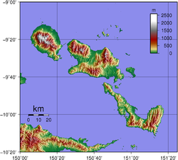 Topographic map of D'Entrecasteaux Islands. Large islands from Northwest to Southeast: Goodenough, Fergusson and Normanby.
The three principal islands, from northwest to southeast, are Goodenough (Nidula[1]), then across Moresby Straight to Fergusson (Moratau[2]), the largest of the three, and across Dawson Straight to Normanby (Duau[2]). In addition there are numerous small islands and reefs. Sanaroa and Dobu are the most significant of the smaller islands. The highest peak in the group is the 2,566 meter Mount Vineuo on Goodenough Island.
The D'Entrecasteaux Islands are volcanic with a number of areas of volcanism and active geothermal fields. Fergusson island has three volcanic masses over 1,828 m high.[3] There are geothermal areas in the south east area of Goodenough Island[4] and the Bwabwadana and Iamalele[5] on Fergusson Island. A particularly active hot springs is located at Deidei on Fergusson. Between Fergusson and Normanby Islands the Dawson Straights Group has several volcanic centres that may define a partly submerged caldera; one of the cones on southwestern Fergusson Island may have erupted in 1350.[6] Geologically the islands are blocks of the Australian plate that were once thrust deep in to the Earth's crust by plate collision. Since then, the blocks have risen to emerge as tall domed structures draped in pieces of the sea floor.
History
The group was named for the French navigator Antoine Raymond Joseph de Bruni d'Entrecasteaux who, in his ship the Espérance, passed through the area in 1792 while searching for his missing compatriot, Jean-François de Galaup, comte de La Pérouse. Almost a century latter in 1874 Captain John Moresby of HMS Basilisk made a running survey of the west coast of the islands and became the first European to make landfall.[7]
In 1891 the Methodist Church of Australia established a mission station on Dobu Island. There natives were recruited to work in gold mines and on copra plantations. Another mission was established in 1898 at Bwaidoga, Mud Bay, on the south coast of Goodenough Island.[7]
The island group became a focus of activity in World War II when Imperial Japanese troops were marooned on Goodenough Island briefly in 1942, before being attacked by the Australian 2/12th Battalion. In 1943 RAAF mobile works squadrons constructed an airfield with a 6,000 ft (1,829 m) airstrip and other facilities at Vivigani Airfield on the site of a smaller, pre-war airstrip that existed at that location. It was used by allied forces from June 1943 to August 1944 as a staging point for operations in New Guinea and nearby occupied islands. Vivigani airstrip has been open to commercial service since 1963. A US Navy PT-Boat base was established on Fergusson Island in June, 1942. Normanby Island may have been a secret British military base during the war.
References
- ^ Young, Michael. (1984) Magicians of Manumanua: Living Myth in Kalauna, Berkeley: University of California Press.
- ^ a b UNEP Islands Website
- ^ http://www.orchidspng.com/island_of_new_guinea.html
- ^ "Goodenough". Global Volcanism Program, Smithsonian Institution. http://www.volcano.si.edu/world/volcano.cfm?vnum=0503-041.
- ^ "Iamalele". Global Volcanism Program, Smithsonian Institution. http://www.volcano.si.edu/world/volcano.cfm?vnum=0503-05=.
- ^ "Dawson Strait Group". Global Volcanism Program, Smithsonian Institution. http://www.volcano.si.edu/world/volcano.cfm?vnum=0503-06=.
- ^ a b D. Jenness M.A. (Oxon) and Rev. A. Ballantyne. (1920) The Northern D'Entrecasteaux, Oxford University Press.
Coordinates: 9°39′S 150°42′E / 9.65°S 150.7°E
Categories:- Islands of Papua New Guinea
- Archipelagoes of the Pacific Ocean
- Milne Bay Province


Wikimedia Foundation. 2010.