- Geography of Italy
-
Coordinates: 42°00′N 12°30′E / 42.0°N 12.5°E Italy is located in southern Europe and comprises the long, boot-shaped Italian Peninsula, the land between the peninsula and the Alps, and a number of islands including Sicily and Sardinia (Corsica, although belonging to the Italian geographical region, has been a part of France since 1769). Its total area is 301,230 square kilometres (116,310 sq mi), of which 294,020 km2 (113,520 sq mi) is land and 7,210 km2 is water (2,784 sq mi).
It lies between latitudes 35° and 48° N, and longitudes 6° and 19° E.
Italy borders with Switzerland (740 km/460 mi), France (488 km/303 mi), Austria (430 km/270 mi) and Slovenia (232 km/144 mi). San Marino (39 km/24 mi) and Vatican city (0.44 km/0.27 mi) are both entirely surrounded by Italy.
Including islands, Italy has a coastline of 7,600 kilometres (4,700 mi) on the Adriatic, Ionian, Tyrrhenian and Ligurian Sea.
Highest peak in Italy is Mont Blanc, at 4,810 metres (15,780 ft) above sea level.
In Italy there is EUs highest mountain Mont-Blanc and highest volcano Etna.
Mountains
Italy is a mountainous country, with the Alps as the northern boundary and the Apennine Mountains forming the backbone of the peninsula, but in between the two lies a large plain in the valley of the Po, the largest river in Italy, which flows 652 km (405 mi) eastward from the Cottian Alps to the Adriatic. Worldwide-known mountains in Italy are Matterhorn (Cervino), Monte Rosa, Gran Paradiso in the West Alps, and Bernina, Stelvio and Dolomites along the eastern side of the Alps.
Rivers and Seas
Most of Italy's rivers drain either into the Adriatic Sea (like Po, Piave, Adige, Reno) or into the Thyrrenian (like Arno, Tiber and Volturno), though the waters from some border municipalities (Livigno in Lombardy, Innichen and Sexten in Trentino-Alto Adige/Südtirol) drain into the Black Sea through the basin of the Drava, a tributary of the Danube, and the waters from the Lago di Lei in Lombardy drain into the North Sea through the basin of the Rhine.
Lakes
In the north of the country are a number of subalpine lakes, the largest of which is Garda (370 km2/143 sq mi). Other well known of these subalpine lakes are Lake Maggiore (212.5 km2/82 sq mi), whose most northerly section is part of Switzerland, and Lake Como (146 km2/56 sq mi).
Islands
Several islands form part of Italy. The largest are Sicily 25,708 km2 (9,926 sq mi) and Sardinia 24,090 km2 (9,301 sq mi). The third island is Elba, the largest island of the Tuscan Archipelago (224 km2/86 sq mi).
Volcanoes
There are also a few active volcanoes in Italy: Etna, the largest active volcano in Europe; Vulcano; Stromboli; and Vesuvius, the only active volcano on the mainland of Europe.
Contents
-

Topographic map of Italy.
-
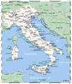
Italy's cities and main towns.
-

Italy viewed from space.
-

Southern Italy and Sicily on the 1849 map.
-

Astronaut photograph highlighting the night-time appearance of southern Italy.
Statistics
Natural resources
Mercury, potash, marble, sulfur, dwindling natural gas and crude oil reserves, fish, coal, arable land.
Countries Italy Borders on: France, Switzerland, Austria and Slovenia.
Land use
- Arable land: 31%
- Permanent crops: 8%
- Permanent pastures: 25%
- Forests and woodland: 15%
- Other: 21% (1993 est.)
Irrigated land
2,100 square kilometres (810 sq mi) (1993 est.)
Natural hazards
Regional risks include landslides, mudflows, avalanches, earthquakes, volcanic eruptions, flooding and land subsidence in Venice.
Maritime claims
- Contiguous zone: 24 nmi (44.4 km; 27.6 mi)
- Continental shelf: 200-metre depth (660 ft) or to the depth of exploitation
- Territorial sea: 12 nmi (22.2 km; 13.8 mi)
Environmental issues
Air pollution from industrial emissions such as sulphur dioxide; coastal and inland rivers polluted from industrial and agricultural effluents; acid rain damaging lakes; inadequate industrial waste treatment and disposal facilities.
Strategy
Strategic location dominating central Mediterranean as well as southern sea and air approaches to Western Europe.
See also
Bibliography
Geography of Europe Sovereign
states- Albania
- Andorra
- Armenia
- Austria
- Azerbaijan
- Belarus
- Belgium
- Bosnia and Herzegovina
- Bulgaria
- Croatia
- Cyprus
- Czech Republic
- Denmark
- Estonia
- Finland
- France
- Georgia
- Germany
- Greece
- Hungary
- Iceland
- Ireland
- Italy
- Kazakhstan
- Latvia
- Liechtenstein
- Lithuania
- Luxembourg
- Macedonia
- Malta
- Moldova
- Monaco
- Montenegro
- Netherlands
- Norway
- Poland
- Portugal
- Romania
- Russia
- San Marino
- Serbia
- Slovakia
- Slovenia
- Spain
- Sweden
- Switzerland
- Turkey
- Ukraine
- United Kingdom
- (England
- Northern Ireland
- Scotland
- Wales)
- Vatican City
States with limited
recognitionDependencies
and other territories- Åland
- Faroe Islands
- Gibraltar
- Guernsey
- Jan Mayen
- Jersey
- Isle of Man
- Svalbard
Other entities Categories:- Geography of Italy
- Geology of Italy
-


Wikimedia Foundation. 2010.