Chabottes

Chabottes

Chabottes

SL380968.JPG
Coat of arms of Chabottes
Chabottes is located in France
{{{alt}}}
Chabottes
Administration
Country France
Region Provence-Alpes-Côte d'Azur
Department Hautes-Alpes
Arrondissement Gap
Canton Saint-Bonnet-en-Champsaur
Intercommunality Champsaur
Mayor Christiane Mioletti
(2008–2014)
Statistics
Elevation 1,028–1,347 m (3,373–4,419 ft)
(avg. 1,080 m/3,540 ft)
Land area1 9.96 km2 (3.85 sq mi)
Population2 750  (2008)
 - Density 75 /km2 (190 /sq mi)
INSEE/Postal code 05029/ 05260
1 French Land Register data, which excludes lakes, ponds, glaciers > 1 km² (0.386 sq mi or 247 acres) and river estuaries.
2 Population without double counting: residents of multiple communes (e.g., students and military personnel) only counted once.

Coordinates: 44°38′38″N 6°10′18″E / 44.6438888889°N 6.17166666667°E / 44.6438888889; 6.17166666667

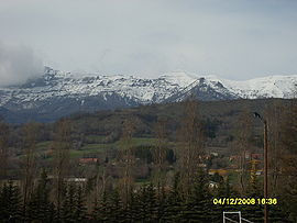
Chabottes is a commune in the Hautes-Alpes department in southeastern France.

Population

Historical population of Chabottes
1962 1968 1975 1982 1990 1999 2008
469 430 461 453 518 610 750

See also

References


Wikimedia Foundation. 2010.

Игры ⚽ Нужно решить контрольную?

Look at other dictionaries:

  • Chabottes — País …   Wikipedia Español

  • Chabottes — 44° 38′ 38″ N 6° 10′ 18″ E / 44.6439, 6.1717 …   Wikipédia en Français

  • Les Chabottes — (Nancroit,Франция) Категория отеля: Адрес: Pont Baudin, 73210 Nancroit, Франция …   Каталог отелей

  • Route départementale 945 (Hautes-Alpes) — Route nationale 545 N 545 Route nationale 545 Déclassements  D 945  Longueur …   Wikipédia en Français

  • Route nationale 545 — N 545 Historique Ouverture 1er janvier 1931 Déclassements  D 945  …   Wikipédia en Français

  • Saint-Jean-Saint-Nicolas — Pour les articles homonymes, voir Saint Jean et Saint Nicolas. 44° 40′ 06″ N 6° 13′ 46″&# …   Wikipédia en Français

  • Saint-Michel-de-Chaillol — Pour les articles homonymes, voir Saint Michel. 44° 40′ 59″ N 6° 10′ 05″ E …   Wikipédia en Français

  • Buissard — Pour les articles homonymes, voir Buissard (homonymie). 44° 39′ 27″ N 6° 08′ 45″ E …   Wikipédia en Français

  • Bénévent-et-Charbillac — Pour les articles homonymes, voir Bénévent (homonymie). 44° 41′ 54″ N 6° 05′ 12″ E …   Wikipédia en Français

  • La Motte-en-Champsaur — 44° 44′ 00″ N 6° 04′ 08″ E / 44.7333333333, 6.06888888889 …   Wikipédia en Français

Share the article and excerpts

Direct link
Do a right-click on the link above
and select “Copy Link”