- Moorlinch
-
Coordinates: 51°07′37″N 2°51′36″W / 51.127°N 2.860°W
Moorlinch 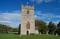
St. Mary's Church
 Moorlinch
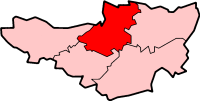
Moorlinch shown within SomersetPopulation 233 [1] OS grid reference ST399367 District Sedgemoor Shire county Somerset Region South West Country England Sovereign state United Kingdom Post town BRIDGWATER Postcode district TA7 Dialling code 01458 Police Avon and Somerset Fire Devon and Somerset Ambulance South Western EU Parliament South West England UK Parliament Bridgwater and West Somerset List of places: UK • England • Somerset Moorlinch is a village and civil parish where the Polden Hills meet the Somerset Levels in the Sedgemoor district of Somerset, England.
Contents
History
The village was known as Mirieling in 971 and the name is believed to come from the Saxon myrge and hlinc meaning pleasant hill.[2]
The parish of Moorlinch was part of the Whitley Hundred.[3]
Moorlinch formed part of the Polden Estate held by Glastonbury Abbey from Saxon times until the dissolution of the monasteries in 1539. Then is descended with Shapwick manor to the Rolle family.[2]
In 1900 the village windmill was demolished and the machinery moved to Ashton windmill in Chapel Allerton.[4]
Governance
The parish council has responsibility for local issues, including setting an annual precept (local rate) to cover the council’s operating costs and producing annual accounts for public scrutiny. The parish council evaluates local planning applications and works with the local police, district council officers, and neighbourhood watch groups on matters of crime, security, and traffic. The parish council's role also includes initiating projects for the maintenance and repair of parish facilities, as well as consulting with the district council on the maintenance, repair, and improvement of highways, drainage, footpaths, public transport, and street cleaning. Conservation matters (including trees and listed buildings) and environmental issues are also the responsibility of the council.
The village falls within the Non-metropolitan district of Sedgemoor, which was formed on April 1, 1974 under the Local Government Act 1972, having previously been part of Bridgwater Rural District,[5] which is responsible for local planning and building control, local roads, council housing, environmental health, markets and fairs, refuse collection and recycling, cemeteries and crematoria, leisure services, parks, and tourism.
Somerset County Council is responsible for running the largest and most expensive local services such as education, social services, libraries, main roads, public transport, policing and fire services, trading standards, waste disposal and strategic planning.
It is also part of the Bridgwater and West Somerset county constituency represented in the House of Commons of the Parliament of the United Kingdom. It elects one Member of Parliament (MP) by the first past the post system of election, and part of the South West England constituency of the European Parliament which elects seven MEPs using the d'Hondt method of party-list proportional representation.
Geography
Moorlinch SSSI is part of the extensive grazing marsh grasslands and ditch systems of the Somerset Levels and Moors. Lying in the Parrett Basin at the foot of the Polden Hills, the area drains by gravity into the King’s Sedgemoor Drain.
Religious sites
The Church of St Mary dates from the 13th century and has been designated by English Heritage as a Grade I listed building.[6]
References
- ^ "Parish Population Statistics for Sedgemoor". ONS Census 2001. Somerset County Council. http://www.webcitation.org/5lRyCSu4c. Retrieved 2009-12-17.
- ^ a b Bush, Robin (1994). Somerset: The complete guide. Wimborne: The Dovecote Press Ltd. pp. 150. ISBN 1874336261.
- ^ "Somerset Hundreds". GENUKI. http://www.genuki.org.uk/big/eng/SOM/Miscellaneous/. Retrieved 22 October 2011.
- ^ Coulthard, Alfred J.; Martin Watts (1978). Windmills of Somerset and the men who worked them. London: Research Publishing Co. pp. 42–44. ISBN 0705000605.
- ^ A Vision of Britain Through Time : Bridgwater Rural District
- ^ "Church of St Mary". Images of England. http://www.imagesofengland.org.uk/details/default.aspx?id=269561. Retrieved 2008-02-03.
External links
 Media related to Moorlinch at Wikimedia Commons
Towns, villages and hamlets in the Sedgemoor district of Somerset, England  Ashcott · Axbridge · Badgworth · Bawdrip · Berrow · Brean · Brent Knoll · Bridgwater · Broomfield · Burnham-on-Sea · Burtle · Cannington · Catcott · Chapel Allerton · Cheddar · Chedzoy · Chilton Polden · Chilton Trinity · Compton Bishop · Cossington · Durleigh · East Brent · Huntspill · Edington · Edithmead · Enmore · Fiddington · Goathurst · Greinton · Highbridge · Lympsham · Lyng · Mark · Middlezoy · Moorlinch · Nether Stowey · North Petherton · Othery · Otterhampton · Over Stowey · Pawlett · Puriton · Shapwick · Shipham · Spaxton · Stawell · Stockland Bristol · Thurloxton · Weare · Wedmore · Wembdon · Westonzoyland · WoolavingtonCategories:
- Villages in Sedgemoor
- Somerset Levels
- Civil parishes in Somerset


Wikimedia Foundation. 2010.