- North Bend, Oregon
-
North Bend, Oregon — City — North Bend from above, looking toward the Pacific Ocean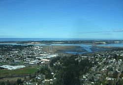 Location in Oregon
Coordinates: 43°24′23″N 124°13′27″W / 43.40639°N 124.22417°WCoordinates: 43°24′23″N 124°13′27″W / 43.40639°N 124.22417°W Country United States State Oregon County Coos Incorporated 1903 Government – Mayor Rick Wetherell Area – Total 5.1 sq mi (13.1 km2) – Land 3.9 sq mi (10.1 km2) – Water 3.0 sq mi (1.2 km2) Elevation 41 ft (12.5 m) Population (2010[1]) – Total 9,695 – Density 2,473.2/sq mi (954.9/km2) Time zone Pacific (UTC-8) – Summer (DST) Pacific (UTC-7) ZIP code 97459 Area code(s) 541 FIPS code 41-53000[2] GNIS feature ID 1146883[3] Website www.northbendcity.org  An aerial view of the Oregon Dunes National Recreation Area, near North Bend.
 See also: Coos Bay, Oregon
North Bend is a city in Coos County, Oregon, in the United States with a population of 9,695 as of the 2010 census.[1][4] North Bend is surrounded on three sides by Coos Bay, an S-shaped water inlet and estuary where the Coos River enters Coos Bay on the Pacific Ocean, and borders the city of Coos Bay, Oregon to the south. North Bend became an incorporated city in 1903.[4]
Contents
Geography and climate
According to the United States Census Bureau, North Bend's total geographic area is 5.1 square miles (13 km2), with 3.9 square miles (10 km2) of land and 1.2 square miles (3.1 km2), (23.08%) of water.
The climate in North Bend and surrounds can be described as a very humid version of the Mediterranean climate or a dry-summer version of a oceanic climate. Typically winter temperatures range from 35 to 55 °F (2 to 13 °C) and summer ranges from 52 to 70 °F (11 to 21 °C), though on the rare occasions continental air masses penetrate they can be much more extreme, with the lowest on record being 0 °F (−18 °C) on 19 December, 1990[5]. Cool breezes off the Pacific moderate the city's climate year round. Rain is abundant in winter, due to moist low pressure troughs from the Pacific Ocean. The city's annual rainfall is about 63.3 inches (1,608 mm), but totals are less than an inch in July and August. Fog often blankets the coastal fringe in summer due to the temperature gradient between the cool Pacific Ocean and the warm inland, which serves to keep temperatures markedly cooler than in Eugene or even Seattle. Snow almost never falls in the city, but can be heavy in the adjacent Oregon Coast Range. Nearby Cape Blanco is one of the windiest places on Earth, with gusts of 125 miles per hour (200 km/h) or more achieved during severe winter storms.
Climate data for North Bend, Oregon Month Jan Feb Mar Apr May Jun Jul Aug Sep Oct Nov Dec Year Record high °F (°C) 74
(23)82
(28)88
(31)90
(32)94
(34)100
(38)98
(37)96
(36)98
(37)99
(37)78
(26)70
(21)100
(38)Average high °F (°C) 52.2
(11.2)54.2
(12.3)55.3
(12.9)58.1
(14.5)60.9
(16.1)64.3
(17.9)66.8
(19.3)67.8
(19.9)67.2
(19.6)63.5
(17.5)57.4
(14.1)53.0
(11.7)60.0 Average low °F (°C) 38.6
(3.7)39.5
(4.2)40.3
(4.6)42.1
(5.6)45.8
(7.7)49.6
(9.8)51.8
(11.0)52.0
(11.1)49.5
(9.7)45.9
(7.7)42.3
(5.7)39.4
(4.1)44.7 Record low °F (°C) 16
(−9)14
(−10)18
(−8)27
(−3)26
(−3)33
(1)31
(−1)30
(−1)30
(−1)26
(−3)20
(−7)0
(−18)0
(−18)Rainfall inches (mm) 10.40
(264.2)8.03
(204)7.64
(194.1)4.74
(120.4)2.99
(75.9)1.66
(42.2)0.43
(10.9)0.60
(15.2)1.89
(48)4.70
(119.4)9.63
(244.6)10.65
(270.5)63.36
(1,609.3)Avg. rainy days (≥ 0.01 inch) 20 17 19 16 13 9 4 5 7 12 18 20 160 Source: [6] Regional history
Before Europeans visited the Oregon coast, Native American tribes claimed the Coos Bay region as their homeland for thousands of years.[7] Members of the Coos, Lower Umpqua, Siuslaw and Coquille tribes lived, fished, hunted and gathered along Coos Bay and its estuaries, along rivers, and in meadows and forests.[7]
Approximately 400 years ago, British and Spanish explorers first approached the South Coast.[7] In 1579 Sir Francis Drake is purported to have sought shelter for his ship, the Golden Hinde, around Cape Arago.[8][9] Trader and explorer Jedediah Smith was in the region seeking furs and the Hudson's Bay Company sent Alexander McLeod to search for an inland passage.[7]
The 1852 stranding of the schooner Captain Lincoln on the North Spit and the survivors' encampment and rescue brought attention to gold prospectors who came to mine placer from area beaches.[7] In 1853 The Coos Bay Commercial Company arrived from the Rogue Valley and created routes for settlers.[7]
Empire City was established and was the county seat of government until 1896.[7] Entrepreneurs were drawn to the area's ample natural resources, and sawmills and shipyards at Old Town North Bend and Empire City spurred economic development and attracted workers.[7] Rivers and sloughs provided a means to transport people, forest, agricultural and coal products, and towns provided hubs for inland transportation.[7] Some of the early industries in the area included timber harvesting, shipbuilding, farming, coal mining and salmon canning.[7]
Prior to around 1915, The Coos region was largely isolated from the rest of Oregon due to difficulties in crossing the Coast Range and fording rivers, and the Pacific Ocean was used to link people to other areas, including San Francisco, which was an easier two-day trip compared to traveling inland over rugged terrain.[7] In 1916 trains were established that linked the region to other interior settlements and towns, which increased commercial trade and tourism[7] Significant urban growth occurred in the 1920s, and during the 1930s to 1950s large-scale growth occurred.[7] Per the Oregon Bay Area Chamber of Commerce, during the 1930s to 1950s:
Shipyards contracted with the U.S. Government to build minesweepers and rescue tugs for World War II defense purposes. Large national lumber companies set up operations and expanded significantly for the next two decades. Jetty improvements, commercial fishing and crabbing shaped the development of Charleston. The completion of the Coos Bay Bridge (now McCullough Memorial Bridge) in 1936 and the Roosevelt Highway significantly improved modern transportation connections and provided the final link in opening the Coos region to the outside world. The formerly remote district known as the Coos Bay country had come of age.[7]
During the interregnum of despair between Franklin Roosevelt's election and his inauguration, the only bank in North Bend, the First National, was forced to temporarily close its doors, precipitating a cash-flow crisis for the City of North Bend. The city solved this problem by minting currency using myrtlewood discs printed on a newspaper press. These coins, in denominations from 25 cents to $10, were used to make payroll and the city promised to redeem them for cash as soon as it became available.[10]
However, when the bank reopened and the city appealed for people to bring their myrtlewood money in to redeem it, many opted to keep their tokens as collector's items. After several appeals, the city gave up and announced that the tokens would remain legal tender in the city of North Bend in perpetuity. Until the 1960s, people occasionally did cash in their tokens, but the remaining pieces have become very valuable through scarcity and historical interest. Fewer than 10 full sets are believed to exist.[11]
Coquille Indian tribe's seat
The seat of the Coquille Indian Tribe's tribal government is located in North Bend, which is a United States recognized sovereign tribe of Native Americans whom have traditionally lived on the southern Oregon Coast.[citation needed] The Coquille Tribe owns several businesses, including The Mill Casino and Hotel, an organic cranberry growing and packing operation in North Bend, Heritage Place assisted living center, and ORCA Communications, a telecommunications provider.[citation needed]
Area amenities and attractions
North Bend is near ocean beaches, including the Oregon Dunes National Recreation Area, which has camping sites, and outdoor recreation opportunities such as all-terrain vehicle driving on the dunes. The Oregon Dunes Recreation Area begins just north of North Bend and attracts approximately 1.5 million visitors each year.[12] North Bend has a public recreational boat ramp that accesses Coos Bay,[13] along with a new concrete pier/boardwalk area that was completed in 2010 per North Bend's regional urban renewal policy.[14] North Bend has a public Olympic-sized indoor pool.[13] The Pony Village Mall in North Bend is the largest mall on the Oregon coast.[13] The Mill Casino is an Indian gaming entertainment center located in North Bend[13] with a hotel, gambling and restaurants. The Bandon Dunes Golf Resort is located about 25 miles south of North Bend.
Transportation
 The Conde McCullough Memorial Bridge in North Bend, Oregon as seen from the east.
Air
The Southwest Oregon Regional Airport is a public airport located in North Bend and the only commercial airport on the Oregon Coast.[citation needed]
Bus
Porter Stage Lines provides bus service from Coos Bay, Oregon with several stops, including Eugene, which has connections with Amtrak rail services and the Greyhound bus network. Porter Stage Lines ends at Ontario, Oregon in eastern Oregon, and then reverses the trip.
Taxi
Yellow Cab taxi company offers taxi service for all of Coos County.
Education
The North Bend School District provides K-12 public education for residents of the area. Southwestern Oregon Community College in nearby Coos Bay offers two-year Associate's degrees and other academic programs.
Demographics
 North Bend's location in Oregon (red dot).
Historical populations Census Pop. %± 1910 2,078 — 1920 3,268 57.3% 1930 4,012 22.8% 1940 4,602 14.7% 1950 6,099 32.5% 1960 7,512 23.2% 1970 8,553 13.9% 1980 9,779 14.3% 1990 9,614 −1.7% 2000 9,544 −0.7% 2010 9,695 1.6% source:[1][15][16] 2000 Census data
Per the 2000 census,[2] there were 9,544 people, 3,969 households, and 2,556 families residing in North Bend and the population density was 2,445.7 people per square mile (944.9/km²). There were 4,291 housing units at an average density of 1,099.6 per square mile (424.8/km²). The ethnic statistics for the city were 92.49% White, 0.38% African American, 1.79% Native American, 1.31% Asian, 0.34% Pacific Islander, 1.03% from other races, and 2.67% from two or more races. Hispanic or Latino of any race were 3.71% of the population.
There were 3,969 households out of which 30.9% had children under the age of 18 living with them, 49.8% were married couples living together, 11.5% had a female householder with no husband present, and 35.6% were non-families. The statistics for how many male householders without a wife present was not recorded by the 2000 Census. 30.1% of all households were made up of individuals and 13.9% had someone living alone who was 65 years of age or older. The average household size was 2.35 and the average family size was 2.91. North Bend's population dispersal was 24.6% under the age of 18, 7.9% from 18 to 24, 25.8% from 25 to 44, 24.6% from 45 to 64, and 17.1% who were 65 years of age or older. The median age was 40 years. For every 100 females there were 90.3 males. For every 100 females age 18 and over, there were 87.5 males. The median income for a household in the city was $33,333, and the median income for a family was $41,755. Male median income was $34,494 and female median income was $23,244. The per capita income for the city was $16,703. About 11.8% of families and 14.8% of the population were below the poverty line, including 20.0% of those under age 18 and 13.0% of those age 65 or over.
2008 demographic data
North Bend's estimated population in July 2008 was 9,636, a 1.0% increase since 2000.[17] There were an estimated 4,572 males (47.5% of the population) and 5064 females (52.5% of the population).[17] The estimated median resident age was 39.6 years.[17] The estimated median household income was $40,745, and the estimated per capita income was $21,041.[17]
2009 demographic data
In 2009 the estimated cost-of-living index in North Bend was 88.1, which is less than the U.S. average of 100.[17]
Mass media
Radio
- KSBA 88.5 FM (public)
- KSOR 89.1 FM (public, translator)
- KJCH 90.9 FM (Christian)
- KMHS-FM 91.3 (high school)
- K219CK 91.7 (translator for KEAR-FM)
- KDCQ 92.9 FM (commercial)
- KTEE 94.9 FM (commercial)
- KTEE 95.7 FM (translator)
- KSHR-FM 97.3 FM (commercial)
- KYTT 98.7 FM (Christian)
- KJMX 99.5 FM (commercial)
- KJMX 100.3 FM (translator)
- KVIP 102.1 FM (Christian, translator)
- KYSJ 105.9 FM (commercial)
- KOOS 107.3 FM (commercial)
- KOOS 107.7 FM (translator)
- KWRO 630 AM (commercial)
- KGRV 700 AM (Christian)
- KDUN 1030 AM (commercial)
- KHSN 1230 AM (commercial)
- KBBR 1340 AM (commercial)
- KMHS 1420 AM (high school)
Television
- KCBY 11 (CBS, This TV) (satellite of KVAL-TV, Eugene)
- K17AA 17 (PBS/OPB) (rebroadcaster of KEPB, Eugene)
- KMCB 23 (NBC) (satellite of KMTR, Eugene)
- K27CL 27 (ABC) (rebroadcaster of KEZI, Eugene)
- K36BX 36 (NBC) (rebroadcaster of KOBI, Medford)
- K44FH 44 (3ABN) (rebroadcaster of KBLN, Grants Pass)
- K63DO 63 (Fox) (rebroadcaster of KLSR-TV, Eugene)
Newspapers
See also
- Coast Guard Air Station North Bend
- Steamboats of Coos Bay (historical)
- Steamboats of the Oregon Coast (historical)
References
- ^ a b c "2010 Census profiles: Oregon cities alphabetically M-P" (PDF). Portland State University Population Research Center. http://www.pdx.edu/sites/www.pdx.edu.prc/files/2010_PL94_cities_M-P_updated.pdf. Retrieved November 6, 2011.
- ^ a b "American FactFinder". United States Census Bureau. http://factfinder.census.gov. Retrieved 2008-01-31.
- ^ "North Bend". Geographic Names Information System, U.S. Geological Survey. http://geonames.usgs.gov/pls/gnispublic/f?p=gnispq:3:::NO::P3_FID:1146883. Retrieved 2008-11-23.
- ^ a b "Incorporated Cities: North Bend". Oregon Blue Book (website). Accessed May 2010.
- ^ NORTH BEND FAA AIRPORT, OREGON: Period of Record General Climate Summary - Temperature
- ^ "NORTH BEND FAA AIRPORT, OREGON (356073)". Western Regional Climate Centre. http://www.wrcc.dri.edu/cgi-bin/cliMAIN.pl?or6073. Retrieved 1 November 2011.
- ^ a b c d e f g h i j k l m n "Bay Area History". Oregon Bay Area Chamber of Commerce. Accessed September 2010.
- ^ Samuel Bawlf (2003). The Secret Voyage of Sir Francis Drake: 1577-1580. New York: Walker & Company; 1St Edition edition (May 1, 2003). pp. 363. ISBN 0802714056.
- ^ "History of Coos Bay". City of Coos Bay. Accessed September 2010.
- ^ http://www.realoregongift.com/Myrtle_Tree_Story/myrtle_tree_story.html
- ^ http://www.offbeatoregon.com/H1008e_north-bend-myrtlewood-money-still-legal-tender.html
- ^ "Oregon Dunes National Recreation Area". U.S. Forest Service, Siuslaw National Forest. Accessed May 2010.
- ^ a b c d North Bend official website. Accessed March 2010.
- ^ "2009-2010 Urban Renewal Budget Message". North Bend Urban Renewal Agency. City of North Bend official website. Accessed July 2010.
- ^ Moffatt, Riley. Population History of Western U.S. Cities & Towns, 1850-1990. Lanham: Scarecrow, 1996, 213.
- ^ "Subcounty population estimates: Oregon 2000-2007" (CSV). United States Census Bureau, Population Division. 2009-03-18. http://www.census.gov/popest/cities/files/SUB-EST2007-41.csv. Retrieved 2009-05-09.
- ^ a b c d e "North Bend, Oregon". Citydata.com. Accessed May 2010.
External links
- Official website
- Coos Bay-North Bend Visitor & Convention Bureau
- Oregon Bay Area Chamber of Commerce official website
- North Bend Visitor Information from Go Northwest
- North Bend, Oregon City Guide and historical information, from The South Coast Oregon Directory
- http://www.offbeatoregon.com/H1008e_north-bend-myrtlewood-money-still-legal-tender.html
Municipalities and communities of Coos County, Oregon Cities 
CDPs Unincorporated
communitiesAllegany | Arago | Bridge | Broadbent | Charleston | Dellwood | Dora | Fairview | Gaylord | Gravelford | Green Acres | Hauser | Laurel Grove | Leneve | Libby | McKinley | Millington | Norway | Prosper | Remote | Riverton | Sitkum | Sumner
Categories:- Cities in Oregon
- Populated coastal places in Oregon
- Populated places in Coos County, Oregon


Wikimedia Foundation. 2010.