- Climate of Chile
-
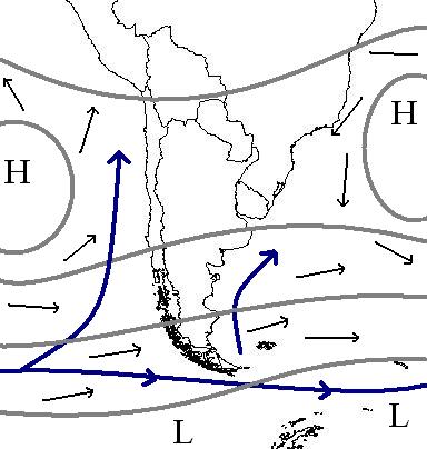
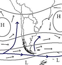 Prevailing winds, sea currents and stationary cyclones near Chile
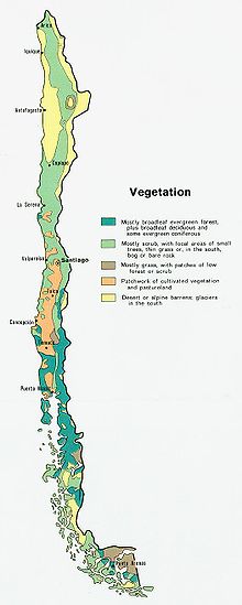 The different climates of Chile are reflected on this vegetation map.
The climate of Chile comprises a wide range of weather conditions across a large geographic scale, extending across 38 degrees in latitude, making generalisations difficult. According to the Köppen system, Chile within its borders hosts at least seven major climatic subtypes, ranging from desert in the north, to alpine tundra and glaciers in the east and southeast, humid subtropical in Easter Island, Oceanic in the south and mediterranean climate in central Chile. There are four seasons in most of the country: summer (December to February), autumn (March to May), winter (June to August), and spring (September to November).
On a synoptic scale the most important factors that controls the climate in Chile are the Pacific Anticyclone, the southern circumpolar low pressure area, the cold Humboldt current, the Chilean Coast Range and the Andes Mountains. Despite Chile's narrowness, some interior regions may experience wide temperature oscillations and cities such as San Pedro de Atacama, may even experience a continental climate. In the extreme northeast and southeast the border of Chile extends beyond the Andes into the Altiplano and the Patagonian plains, giving these regions climate patterns similar to those seen in Bolivia and Argentina respectively.
Contents
Regions
“ It [Chile] has four months of winter, no more, and in them, except when there is a quarter moon, when it rains one or two days, all the other days have such beautiful suns... ” Climate Ecoregion Natural region Desert (BWh, BWk) Atacama desert Norte Grande Semi-arid (BWk, BSk, Csa) Atacama desert, Chilean matorral Norte Chico Mediterranean (Csa, Csb) Chilean matorral Central Chile Humid subtropical (Cfa) Easter Island, Fernandezian Region - Temperate oceanic (Cfb) Valdivian temperate rainforests Zona Sur, Zona Austral Subpolar oceanic (Cfc) Magellanic subpolar forests Zona Austral Semi-arid (BSk) Patagonian Desert Zona Austral Alpine Andes, Central Andean dry puna all natural regions of Chile Tundra (ET) Andes, Central Andean dry puna all natural regions of Chile Ice cap (EF) Northern Patagonian Ice Field, Southern Patagonian Ice Field Zona Austral Andes
There is no proper Andean climate, but instead a huge variety of different micro climates. The relief of the Andes allows a variety of different climatic zones to develop within relatively short distances. The different climates in the Andes often combine aspects of adjacent climate zones forming transition zones. In glaciology, Andes mountains can be divided in two climatic subregions; the Dry Andes and the Wet Andes.
Subtropical
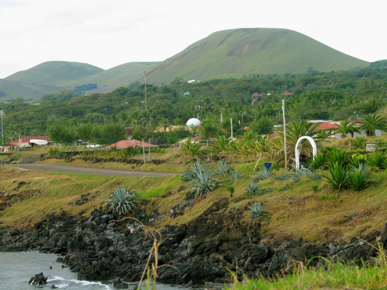
 View toward the interior of Easter Island
The climate of Easter Island is subtropical maritime. The lowest temperatures are registered in July and August (18°C - 64°F) and the highest in February (maximum temperature 28°C [1]), the summer season in the southern hemisphere. Winters are relatively mild. The rainiest month is April, though the island experiences year-round rainfall.[2] As an isolated island Easter Island is constantly exposed to winds which help to keep the temperature fairly cool. Precipitation averages 1,118 mm per year. Occasionally, heavy rainfall and rainstorms strike the island. These occur mostly in the winter months (June–August). Since it is close to the Pacific High and outside the range of the ITCZ, cyclones and hurricanes do not occur around Easter island.[3]
Dry arid
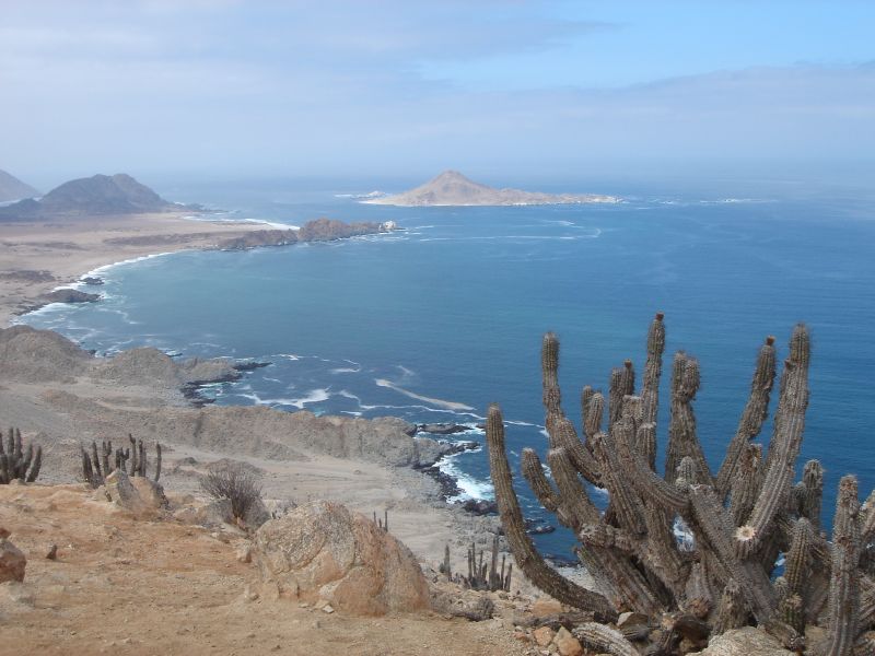
See also: Atacama DesertThe Atacama Desert is the driest place on Earth, and is virtually sterile because it is blocked from moisture on both sides by the Andes mountains and by the Chilean Coast Range. The cold Humboldt Current and the Pacific Anticyclone are essential to keep the dry climate of Atacama Desert. The average rainfall in the Chilean region of Antofagasta is just 1 mm per year. Some weather stations in the Atacama have never received rain. Evidence suggests that the Atacama may not have had any significant rainfall from 1570 to 1971.[4] It is so arid that mountains that reach as high as 6,885 metres (22,590 feet) are completely free of glaciers and, in the southern part from 25°S to 27°S, may have been glacier-free throughout the Quaternary — though permafrost extends down to an altitude of 4,400 metres and is continuous above 5,600 metres. Studies by a group of British scientists have suggested that some river beds have been dry for 120,000 years.
Some locations in the Atacama do receive a marine fog known locally as the Camanchaca, providing sufficient moisture for hypolithic algae, lichens and even some cacti. But in the region that is in the "fog shadow" of the high coastal crest-line, which averages 3,000 m height for about 100 km south of Antofagasta, the soil has been compared to that of Mars.
Mediterranean
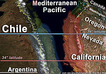 Mediterranean climate distribution in the Americas. Note that the map of Chile is turned upsidedown
The climate of Central Chile is of temperate Mediterranean type, with the amount of rainfall increasing considerably and progressively from north to south. In the Santiago area, the average monthly temperatures are about 19.5 °C in the summer months of January and February and 7.5 °C in the winter months of June and July. The average monthly precipitation is no more than a trace in January and February and 69.7 millimeters in June and July. By contrast, in Concepción the average monthly temperatures are somewhat lower in the summer at 17.6 °C but higher in the winter at 9.3 °C, and the amount of rain is much greater. In the summer, Concepción receives an average of twenty millimeters of rain per month; in June and July, the city is pounded by an average of 253 millimeters per month. The numerous rivers greatly increase their flow as a result of the winter rains and the spring melting of the Andean snows, and they contract considerably in the summer. The combination of abundant snow in the Andes and relatively moderate winter temperatures creates excellent conditions for Alpine skiing. Areas around the Bío-Bío River, historically called La Frontera corresponds to southern limit of the mediterranean climate, with typical mediterranean fruits such as avocado, citrus, olives and grapes being cultivated north of it and oat, wheat, apples and potatoes to the south. This more or less drastic transition is caused by the split of the westerlies at these latitudes (~37° S) into one branch going to the southeast and another to the northeast, to this it is necessary to add the north-south lowering of the Chilean Coast Range which reduced the rain shadow effect.[5]
Temperate oceanic
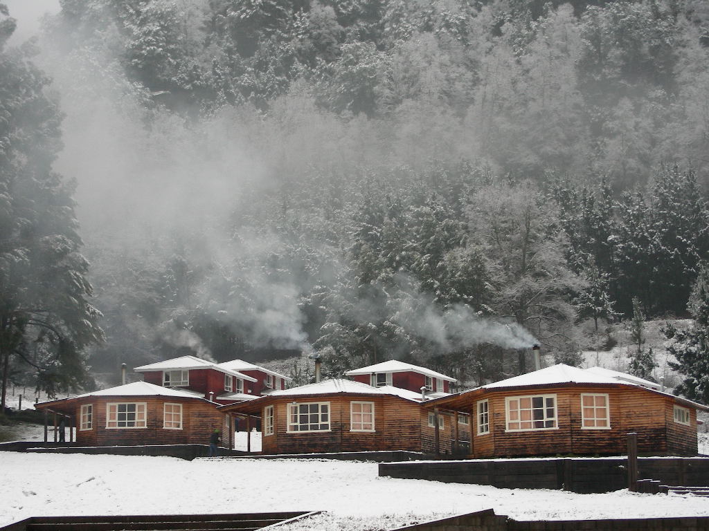
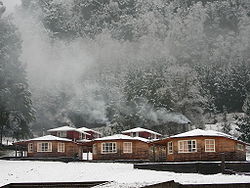 Maritime influence makes some southern Andean valleys prone to snowfalls in winter such as in Curarrehue in the picture.See also: Climate of Valdivia
In Zona Sur and the northern part of Zona Austral the climate is Temperate oceanic. Here the Andean Cordillera intercepts moist westerly winds along the Pacific coast during winter and summer months; these winds cool as they ascend the mountains, creating heavy rainfall on the mountains' west-facing slopes. The northward-flowing oceanic Humboldt Current creates humid and foggy conditions near the coast. The tree line is at about 2,400 m in the northern part of the ecoregion (35° S), and descends to 1,000 m in the south of the Valdivian region. In the summer average temperature can climb to 16.5°C (62°F), while during winter the temperature can drop below 7°C (45°F).[6]
Subpolar oceanic
The seasonal temperature in Zona Austral is greatly moderated by its proximity to the ocean and is known for stable constant temperatures, only small variability with season. The heaviest rainfalls goes between April and May and snow season goes all through Chilean winter (June till September), although the average temperature does not descend below 1°C in coastal areas.[7]
Climate charts for different locations of Chile
Iquique Climate chart (explanation) J F M A M J J A S O N D 025180251802417022150.220140.1191401813018130191402015022150.22417Average max. and min. temperatures in °C Precipitation totals in mm Source: [1] Imperial conversion J F M A M J J A S O N D 077640776407562072590695706656064560655606657068580716007462Average max. and min. temperatures in °F Precipitation totals in inches Antofagasta Climate chart (explanation) J F M A M J J A S O N D 024170241702316021140191331811517113171101812319130211402216Average max. and min. temperatures in °C Precipitation totals in mm Source: [2] Imperial conversion J F M A M J J A S O N D 07563075630736107057066550.164520.263520.16352064540.166550705707261Average max. and min. temperatures in °F Precipitation totals in inches Copiapó Climate chart (explanation) J F M A M J J A S O N D 0.12914029140.428120.62590.22271.42155.22152.22270.42480.726100271202913Average max. and min. temperatures in °C Precipitation totals in mm Source: [3][4] Imperial conversion J F M A M J J A S O N D 08558085580825407749071450.169410.269410.1724407646079500805308455Average max. and min. temperatures in °F Precipitation totals in inches Santiago Climate chart (explanation) J F M A M J J A S O N D 0291232912527913227581857914376143531642818613227525952811Average max. and min. temperatures in °C Precipitation totals in mm Source: [5] Imperial conversion J F M A M J J A S O N D 084540.184540.281480.572452.364413.15737357372.161391.164430.572450.277480.28252Average max. and min. temperatures in °F Precipitation totals in inches Linares Climate chart (explanation) J F M A M J J A S O N D 1530121129122325955216186166211125160123127144681754920729249162812Average max. and min. temperatures in °C Precipitation totals in mm Source: [6][7] Imperial conversion J F M A M J J A S O N D 0.686540.484540.977482.270437.361438.354416.35437557392.763411.968451.175480.68254Average max. and min. temperatures in °F Precipitation totals in inches Concepción Climate chart (explanation) J F M A M J J A S O N D 212110152110201995617717814721813622212415313588146651674118828209Average max. and min. temperatures in °C Precipitation totals in mm Source: [8][9] Imperial conversion J F M A M J J A S O N D 0.870500.670500.866482.26345757458.655438.75439655413.557432.661451.664461.16848Average max. and min. temperatures in °F Precipitation totals in inches Valdivia Climate chart (explanation) J F M A M J J A S O N D 6623117423111322192341783611365501163941153281242081451271771251881042110Average max. and min. temperatures in °C Precipitation totals in mm Source: [10] Imperial conversion J F M A M J J A S O N D 2.673522.973525.270489.263461455432252431652411354398.25741563454.964464.17050Average max. and min. temperatures in °F Precipitation totals in inches Puerto Montt Climate chart (explanation) J F M A M J J A S O N D 902099319999188143157234136224114229104209114146134121146112177103199Average max. and min. temperatures in °C Precipitation totals in mm Source: [11] Imperial conversion J F M A M J J A S O N D 3.567493.767483.964465.659449.255438.85139951398.252395.755404.858424.462454.16547Average max. and min. temperatures in °F Precipitation totals in inches Aisén Climate chart (explanation) J F M A M J J A S O N D 19018819017821015719012537093260712806128081160102190125170146200168Average max. and min. temperatures in °C Precipitation totals in mm Source: [12] Imperial conversion J F M A M J J A S O N D 7.564467.563468.359457.554411548371045341143341146346.350367.554416.757437.96146Average max. and min. temperatures in °F Precipitation totals in inches Balmaceda Climate chart (explanation) J F M A M J J A S O N D 281772117737155521128971843−1843−168614581291132813533166Average max. and min. temperatures in °C Precipitation totals in mm Source: [13] Imperial conversion J F M A M J J A S O N D 1.163450.863451.55941252363.545343.337303.337302.743341.846341.152371.155411.36143Average max. and min. temperatures in °F Precipitation totals in inches Punta Arenas Climate chart (explanation) J F M A M J J A S O N D 3814723147331253610433724151284−131612382281131812436146Average max. and min. temperatures in °C Precipitation totals in mm Source: [14] Imperial conversion J F M A M J J A S O N D 1.557450.957451.354411.450391.345361.641341.139301.243340.946361.152370.754391.45743Average max. and min. temperatures in °F Precipitation totals in inches Easter Island Climate chart (explanation) J F M A M J J A S O N D 922621872621862621118242012823191022118942017862016842117732117802318922419Average max. and min. temperatures in °C Precipitation totals in mm Source: [15][16] Imperial conversion J F M A M J J A S O N D 3.679703.479703.479704.6756857366470643.768633.468613.370632.970633.173643.67566Average max. and min. temperatures in °F Precipitation totals in inches See also
- Agriculture in Chile
- Geography of Chile
- Geology of Chile
- Glaciers of Chile
- Natural regions of Chile
- White Earthquake
Sources
References
- ^ Enjoy Chile - climate
- ^ Easter Island Article in Letsgochile.com
- ^ Weather Easter Island Foundation
- ^ Wright, John W. (ed.); Editors and reporters of The New York Times (2006). The New York Times Almanac (2007 ed.). New York, New York: Penguin Books. pp. 456. ISBN 0-14-303820-6.
- ^ Schwedtfeger, Werner. 1976. The Climate of Chile. World Survey of Climatology. Elsevier Scientific Publishing Company.
- ^ Di Castri F di & E. Hajek 1976. "Bioclimatología de Chile" 163 pages with english summary
- ^ Punta Arenas article in Letsgochile.com
Climate of South America Sovereign states Dependencies and
other territories- Aruba
- Bonaire
- Curaçao
- Falkland Islands
- French Guiana
- South Georgia and the South Sandwich Islands
Categories:


Wikimedia Foundation. 2010.