Medway Valley Walk

Medway Valley Walk
Medway Valley Walk
YaldingTwyford0529.JPG
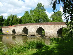
Joined by the Greensand Way- The Twyford Bridge, Yalding, Kent
Length 31 kilometres (19 mi)
Location South Eastern England, United Kingdom
Trailheads Rochester, Kent
Tonbridge, Kent
Use Walking
Highest point 21 metres (69 ft)
Lowest point 0 metres (0 ft)
Trail difficulty Easy
Season All year
Sights Kentish countryside
The Medway Valley Walk, and the other long-distance footpaths in Kent

The Medway Valley Walk follows the River Medway from Rochester to Tonbridge. Above Allington, it follows the bank of the Medway Navigation. It starts on the Saxon Shore Way at Rochester. The North Downs Way crosses the Medway Valley Walk at the eastern end of the Medway Viaduct or motorway bridge. The Greensand Way crosses the walk at Yalding. At West Peckham, it is joined by the Wealdway which continues through to Tonbridge, thus linking with the Eden Valley Walk.

The Maidstone Millennium River Park is a 10 kilometre (6 mi) stretch from Teston Country Park to the Museum of Kent Life at Sandling. It follows the walk. The park was built between 1998 and 2001; it has transformed 18 acres (7.3 ha) of wasteland and led to the construction of three new footbridges over the river all accessible from the walk.

References

Coordinates: 51°17′37″N 0°30′41″E / 51.2935°N 0.5115°E / 51.2935; 0.5115


Wikimedia Foundation. 2010.

Игры ⚽ Нужна курсовая?

Look at other dictionaries:

  • River Medway — For similarly named rivers, see Medway River (disambiguation). Coordinates: 51°26′57″N 0°44′18″E / 51.44917°N 0.73833°E / 51.44917; 0.73833 …   Wikipedia

  • Maidstone — For other uses, see Maidstone (disambiguation). Coordinates: 51°16′19″N 0°31′44″E / 51.272°N 0.529°E / 51.272; 0.529 …   Wikipedia

  • River Bourne, Kent — For an explanation of the various pieces of machinery mentioned, see Mill machinery. River Bourne The River Bourne enters the Medway Origin Ightham …   Wikipedia

  • Yalding — infobox UK place country = England static static image caption=Georgian buildings on the High Street, Yalding official name= Yalding latitude= 51.2166 longitude= 0.4333 population = shire district= Maidstone (borough) shire county = Kent region=… …   Wikipedia

  • Recreational walks in Kent — The following are lists of recreational walks in Kent, England.hort walks*Beacon Wood Country Park, located on the B225 road close to Bean, south of Bluewater Shopping Centre. Has circular walks and an easy access route. No toilets. *Bedgebury… …   Wikipedia

  • Saxon Shore Way — Coastline= The Saxon Shore Way starts at Gravesend, Kent and traces the coast as it was in Roman times (note the changed coastline around Romney Marsh) as far as Hastings, East Sussex, 163 miles (262 km) in total.HistoryThe line of the Roman… …   Wikipedia

  • Teston — (pronounced ’’Teesun’’The Place Names of Kent,Judith Glover,1976,Batsford. ISBN 0905270 614 ] ) is a village in the civil parish of Barming in the Maidstone District of Kent, England. It is located on the A26 road out of Maidstone, four miles… …   Wikipedia

  • North Kent Line — The North Kent Line, shown with other railway lines in Kent. Overview Type Commuter rail, Suburban rail System …   Wikipedia

  • New York and New England Railroad — Washington Secondary Rail Trail, built over the former Rhode Island portion of the NY NE Locale Boston, MA to New York State Dates of op …   Wikipedia

  • River Stour, Kent — Infobox River river name = River Stour image size = caption = River Stour and Tributaries origin = Postling and Lenham mouth = Pegwell Bay basin countries = length = elevation = mouth elevation = discharge = watershed = The River Stour… …   Wikipedia

Share the article and excerpts

Direct link
Do a right-click on the link above
and select “Copy Link”