- Oxon Cove Park and Oxon Hill Farm
-
Oxon Cove Park and Oxon Hill Farm IUCN Category V (Protected Landscape/Seascape)Map of the United States

Location Prince George's County, Maryland, USA Nearest city Oxon Hill, Maryland Coordinates 38°48′17″N 77°00′43″W / 38.8046°N 77.01182°WCoordinates: 38°48′17″N 77°00′43″W / 38.8046°N 77.01182°W Established 1959 Governing body National Park Service Oxon Cove Park Oxon Hill Farm, December 2010
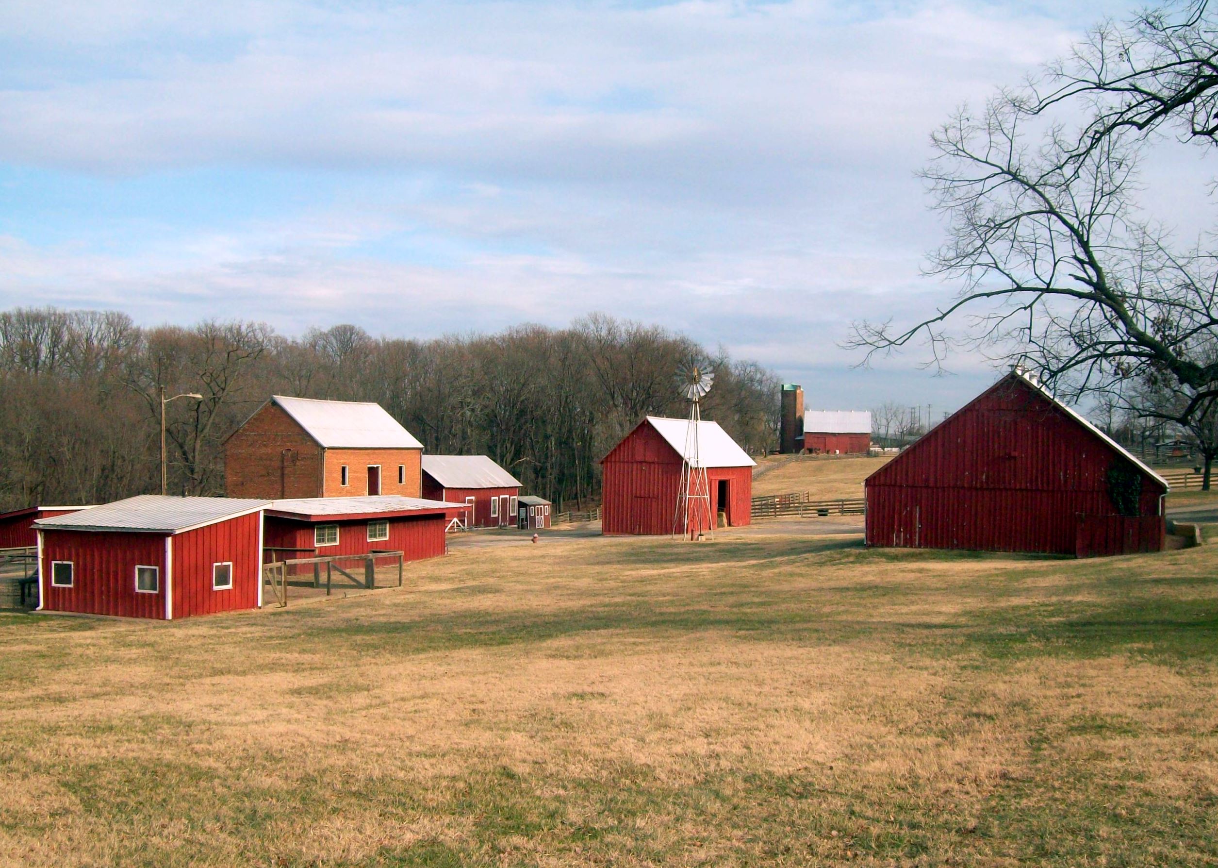
Location: Government Farm Rd., Oxon Hill, Maryland Area: 289 acres (117 ha) Architectural style: Italianate, et al. Governing body: National Park Service NRHP Reference#: 03000869[1] Added to NRHP: September 02, 2003 Oxon Cove Park and Oxon Cove Farm is a national historic district that includes a living farm museum operated by the National Park Service, and located at Oxon Hill, Prince George's County, Maryland. It was listed on the National Register of Historic Places in 2003.[1]
The park provides an excellent resource for environmental studies, wildlife observing, fishing, and other recreational activities made possible by easy access to the Potomac River. Fourteen buildings and two structures are located in the historic district and associated with the property's sequential development as a plantation, an institutional agricultural complex, and a farm museum.[2]
Contents
Oxon Hill Farm
The Oxon Hill Farm includes the Mount Welby home, Farm Museum, barns, a stable, feed building, livestock buildings and a visitor activity barn. Farm animals include cows, horses and chickens. Visitors can view the animals up close daily and learn about the workings of a farm. The Farm Museum building displays historical farm equipment dating from the late 19th century.
The district also includes a hexagonal frame outbuilding; ca. 1830 brick root cellar; ca. 1973 frame hog house; ca. 1890 frame horse and pony barn; ca. 1991 frame chicken house; ca. 1970 steel-frame implement shed; ca. 1980 frame visitor barn; ca. 1970 steel-frame windmill; ca. 1940 frame hay barn; ca. 1890 frame feed building; ca. 1830 brick stable; ca. 1970 frame tool shed; ca. 1980 frame "sorghum sirip" shed; and a ca. 1980 frame dairy barn, and ca. 1940 tile silo. From the 1890s to 1950s, under the ownership of St. Elizabeth's Hospital, the site was used as a therapeutic treatment center for the mentally ill known as Godding Croft. The Oxon Cove Farm historic district is located on the crest of a ridge overlooking the Potomac River, north of I-95.[3]
Mount Welby
The principal dwelling, known as "Mount Welby," is a ca. 1807-1811 two-story three-bay brick structure laid in Flemish bond with Italianate detailing and sheltered by a shed roof, and visible to motorists crossing the interstate Woodrow Wilson Bridge. The house was built by Irish immigrant Dr. Samuel DeButts. It was entrusted to the National Park Service in 1959 in order to protect its resources from increased development.[4] From 1891 to 1950, the property was used as a therapeutic farm by St. Elizabeths Hospital, and was known as Godding Croft.
The house is operated as a historic house museum, with exhibits about period life in the early 19th century for the owners and slaves on the plantation. Other exhibits focus on the home's role at Godding Croft.
Gallery
-

NPS Official "Oxon Hill Farm / Oxon Cove Park Fall View," November 2008
-

Mt. Welby and Root Cellar, December 2010
-

Mt. Welby, December 2010
See also
Protected Areas of Maryland Federal Catoctin Mountain Park • Fort Foote Park • Fort Washington Park • Glen Echo Park • Greenbelt Park • Harmony Hall • Oxon Cove Park and Oxon Hill Farm • Piscataway Park
Blackwater • Eastern Neck • Martin • Patuxent Research Refuge • Susquehanna RiverState Assateague • Big Run • Bill Burton Fishing Pier State Park • Calvert Cliffs • Casselman River Bridge • Chapel Point • Cunningham Falls • Dans Mountain • Deep Creek Lake • Elk Neck • Fort Frederick • Fort Tonoloway • Gambrill • Gathland • Greenbrier • Greenwell • Gunpowder Falls • Hart-Miller Island • Herrington Manor • Janes Island • Jonas Green • Martinak • Matapeake • New Germany • North Point • Palmer • Patapsco Valley • Patuxent River • Pocomoke River • Point Lookout • Purse • Rocks • Rocky Gap • Rosaryville • Sandy Point • Seneca Creek • Smallwood • South Mountain • St. Clement's Island • St. Mary's River • Susquehanna • Swallow Falls • Tuckahoe • Washington Monument • Wye Oak
Cedarville • Chesapeake • Doncaster • Elk Neck • Garrett • Green Ridge • Pocomoke • Potomac-Garrett • Savage River • Seth • Stoney • Wicomico
Avondale • Belle Grove • Billmeyer • Bowen • Cedar Island • Cedar Point • Cheltenham • Chicamuxen • Dan's Mountain • Deal Island • Diersson • E.A. Vaughn • Earlville • Ellis Bay • Fairmount • Fishing Bay • Frederick City Watershed • Grove Farm • Gwynnbrook • Heater's Island • Hugg-Thomas • Idylwild • Indian Springs • Islands of the Potomac • Isle of Wight • Johnson • Le Compte • Linkwood • McKee-Beshers • Maryland Marine Properties • Millington • Mt. Nebo • Myrtle Grove • Nanticoke River • Old Bohemia • Pocomoke River • Prather’s Neck • Pocomoke Sound • Sideling Hill • Sinepuxent Bay • South Marsh • Strider • Taylors Island • Warrior Mountain • Wellington
Belt Woods • Dundee • Governor Parris N. Glendening • Mattawoman • Morgan Run • Severn Run • Soldiers Delight • Zekiah Swamp
County and
MunicipalParks & SanctuariesAcorn Park • Clifton Park • Constitution Park • Fort Smallwood Park • Jug Bay Wetlands Sanctuary • Lake Centennial • Lake Elkhorn • Lakelands Park • Oregon Ridge Park • Patterson Park • Robert E. Lee Memorial ParkNon-governmental Parks & SanctuariesBattle Creek Cypress Swamp Sanctuary • Merkle Wildlife Sanctuary • Sherwood Gardens • Somers Cove Marina • Sugarloaf Mountain • Western Maryland Rail Trail • Youghiogheny Scenic & Wild River
Maryland Department of Natural Resources (web): Maryland Park Service (web) and Maryland Forest ServiceU.S. National Register of Historic Places in Maryland Lists by county Allegany • Anne Arundel • Baltimore County • Calvert • Caroline • Carroll • Cecil • Charles • Dorchester • Frederick • Garrett • Harford • Howard • Kent • Montgomery • Prince George's • Queen Anne's • Somerset • St. Mary's • Talbot • Washington • Wicomico • Worcester
Lists by city Other lists References
- ^ a b "National Register Information System". National Register of Historic Places. National Park Service. 2009-03-13. http://nrhp.focus.nps.gov/natreg/docs/All_Data.html.
- ^ "Mount Welby". Maryland Historical Trust. http://www.mncppc.org/county/Illustrated_Inventory906/102_127.pdf. Retrieved 2008-10-29.
- ^ "Oxon Cove Farm". Maryland Historical Trust. http://www.mht.maryland.gov/nr/NRDetail.aspx?HDID=1426&COUNTY=Prince%20Georges&FROM=NRCountyList.aspx?COUNTY=Prince%20Georges. Retrieved 2008-10-29.
- ^ Oxon Cove Park: History & Culture
External links
- National Park Service, National Capital Parks - East, Oxon Cove Park and Oxon Hill Farm website
- Oxon Cove Farm, Prince George's County, Inventory No.: PG:76A-13, including photo in 1988, at Maryland Historical Trust website
- M-NCPPC Inventory of Historic Sites (Prince George's County); Mount Welby, entry 76A-013, p. 118
- The Historical Marker Database, Oxon Cove Park and Oxon Hill Farm entry
Categories:- IUCN Category V
- Historic districts in the United States
- Parks in Prince George's County, Maryland
- Farm museums in Maryland
- Houses on the National Register of Historic Places in Maryland
- Historic districts in Maryland
- Museums in Prince George's County, Maryland
- Protected areas established in 1959
- Italianate architecture in Maryland
- United States National Park Service areas in Maryland
- National Capital Parks-East
- Houses in Prince George's County, Maryland
-


Wikimedia Foundation. 2010.