- Crondall
-
Coordinates: 51°14′00″N 0°51′46″W / 51.233262°N 0.86272717°W
Crondall 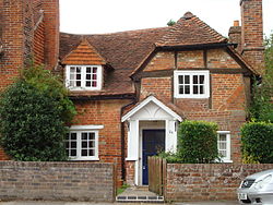
A typical village house in Crondall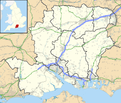
 Crondall
Crondall shown within HampshireOS grid reference SU7949948845 Parish Crondall District Hart Shire county Hampshire Region South East Country England Sovereign state United Kingdom Post town FLEET Postcode district GU15 Dialling code 01252 01276 Police Hampshire Fire Hampshire Ambulance South East Coast EU Parliament South East England UK Parliament Aldershot List of places: UK • England • Hampshire Crondall is a village and large civil parish in the north east of Hampshire, England and is all that remains of the old Hundred of Crondall referred to in the Domesday Book of 1086. Various earlier spellings have in common the use of a "u" instead of the "o" and the village is still properly pronounced "Crundel" although some recent incomers prefer to pronounce the "o". The map of Hampshire in the 1722 edition of William Camden's Britannia or Geographical Description of Britain and Ireland shows symbols for habitation in Farnborough, Cove, Ewshot, Aldershot and Crookham in the Crundhal (Crondall) hundred.[1]
Contents
History
Pre-Norman
An Old English crundel was a chalk-pit or quarry, and the word has survived in the name of Crondall. The remains of one quarry can still be seen as a large depression on the golf course.
Crondall's southern boundary is the North Downs along which ran the prehistoric Harrow Way, thought to be the oldest road in Britain which ran from the Cornish tin mines to Dover in Kent. There is some evidence for Neolithic settlements since there is an Iron Age earthworks at Caesar's Camp. Remains of Roman and Norman settlements have been found close beside the Harrow Way near Barley Pound. Evidence for Roman occupation can be found in the fields as broken tiles and artefacts. In 1817 an intact Roman mosaic pavement was found by a ploughman, and is commemorated by a tapestry in the parish church. Coins from the third century were found in 1869.
The "Crondall Hoard" of one hundred and one old French coins, two jewelled ornaments, and a chain were found in 1828. Many of these date to the fifth century and ninety seven of the coins are now in the possession of the Ashmolean Museum at Oxford.[2]
King Alfred the Great bequeathed the Hundred of Crondall to his nephew Eltham in 885. In 975 it was handed over by King Edgar to the monks at Winchester; and remained in their hands until 1539. At this time Henry VIII dissolved the monasteries and within two years Crondall was controlled by the new Dean and Chapter of Winchester Cathedral. Crondall remained in their hands until 1861, when it was taken over by the Ecclesiastical Commissioners [1].
Manors
The Hundred of Crondall was divided into 'Manors', Itchell, Ewshot, Crokeham, Well, Feldmead, Dippenhall, Farnborough and Aldershot. These Manors are all mentioned in the records of Winchester Cathedral. All the land within the Hundred was administered by the Lords of the Manor at Crondall on behalf of the monks of St Swithen and later on behalf of Winchester Cathedral.
Itchell Manor's gardens (house demolished 1954) were laid out by Capability Brown. A greenhouse, built 1840, is still in use and a Tudor Gateway remains. The Old Itchell Manor House had the reputation of being haunted when members of the Lefroy family were in residence. The apparition took the form of a phantom coach racing away from the manor and down nearby Hyde Lane.
Civil War
All Saints' church in Crondall was a minor parliamentary outpost for much of the English Civil War, guarding the western approaches to Farnham.
Tithe map
A Tithe Map of The Hundred of Crondall, dated 1846, is housed at the Hampshire County Archive in Winchester.
Industry
Crondall has for centuries been rich farming land. A great variety of soils appear in the area because it lies on the edge of the London Basin including chalk, clay and heavy fertile loam. There are many natural springs in the area that were used as watercress beds and for growing osier trees for basket weaving. Some of the baskets were incorporated into the balloon baskets and airship gondolas used by S.F. Cody in his early aviation experiments at Farnborough. The area was also renowned for hops that were grown here for two hundred years until the last war. For many years Crondall had a brickworks that supplied tiles and brick to local towns.
Architecture
Barley Pound, Motte and Bailey
 Barley Pound
Barley Pound is a large ring-motte with four baileys and is one of the best examples of a ring and bailey fortress in Hampshire. The fortication may be the "Lidelea Castle" which was mentioned in the Gesta Stephani for 1147, when it was besieged and captured by King Stephen. After its return to Henry of Blois, Bishop of Wincheter it was abandoned in favour of Farnham Castle.[3] Archaeological work has uncovered evidence of an 8 inch thick wall along with a masonry keep.[4]
To the east is Powderham Castle[5][6] which was a siege-castle to Barley Pound. It too was founded by the Bishop of Winchester and built during The Anarchy in the reign of King Stephen. It was originally an earth and timber ringwork fortress, encased by a ditch and with a counterscarp bank. Due to the demolition of its encasing rampart, the ringwork now resembles a low flat-topped motte. It now also has a dense cover of trees. Excavations on the mound have uncovered post-holes and large flints which may indicate former buildings.
All Saints, Norman Church
 All Saints Church
The 12th Century Norman parish church, All Saints, has been called 'The Cathedral of North Hampshire'. It replaced a Saxon church on the same site and the Saxon font remains from that period. The east end of the Nave dates to 1170. The original bell tower was poorly designed for the weight of the bells it housed and by 1657 the whole tower had to be dismantled to prevent its total collapse. In 1659 a new brick tower, modelled on St Matthews in Battersea, was erected at the NE corner of the original structure.
Among notable interior features are an ancient brass of 1370, the dogtooth mouldings of the chancel arch and the imposing arcades and foliate capitals of the Nave. To date All Saints has undergone two major restorations, the first in 1847 by the architect Benjamin Ferrey and the second in 1871 under the guidance of Sir George Gilbert Scott. In 1995 the "National Association of Decorative and Fine Arts Societies" (NADFAS) declared All Saints to be one of the finest examples of architecture of its style in the country. The church is said to be haunted.
The church operates as part of the Parish of Crondall and Ewshot.
Residential buildings
Throughout Crondall there are many well-preserved old houses and cottages. The Plume of Feathers pub is a fine example of Tudor architecture and was a resting stop on the turnpike to Portsmouth.
Notable visitors
A panoramic view of this part of Hampshire may be gained from Queens View looking from East to West across Crondall. It takes its name from the fact that Queen Victoria admired this view whilst inspecting troops garrisioned at nearby Aldershot "Home of the British Army". Oliver Cromwell is reputed to have stayed in the Plume of Feathers in October 1645, when the siege of Basing House was in progress.[7]
Notable residents include Chris Fawkes, a weatherman for the BBC.
Statistics
As of 2005, Crondall consists of some or all of the following areas: Bentley, Bucks Horn Oak, Crondall, Ewshot, Mill Lane, Batt's Corner, Charleshill, Churt, Dippenhall, Frensham, Millbridge, Rowledge, Rushmoor, Seale, Spreakley, The Sands, Tilford and Tongham.[citation needed]
- According to the 2001 census. 3463 people live in Crondall.
- There are about 1478 dwellings in the ward.
- The parish covers 10.7 square miles (27.7 km²).
Further reading
- Arnold Taylor The Seventeenth-Century Church Towers of Battersea (1639) Staines (1631), Crondall (1659) and Leighton Bromswold (?c. 1640), Architectural History Vol. 27, Design and Practice in British Architecture: Studies in Architectural History Presented to Howard Colvin (1984), pp. 281–296 (article consists of 16 pages) Published by: SAHGB Publications Limited
- Roland P Butterfield Monastery and Manor. The History of Crondall [138p] Printed by EW Langham, Farnham, 1948
- Roland P Butterfield (editor) Ordained in Powder : The Life and Times of Parson White of Crondall Published 1966 by Herald P in Farnham (Sy.)
References
- ^ Samuel Lewis' A Topographical Dictionary of England of 1831 also describes both Ewshot and Crookham as in the parish and hundred of Crondall
- ^ Hampshire Treasures Volume 3 (Hart and Rushmoor) Page 7 - Crondall
- ^ Barley Pound at castleuk.net
- ^ Barron, William (1985). The Castles of Hampshire & Isle of Wight. Paul Cave Publications. p. 6. ISBN 0861460480.
- ^ Powderham Castle at castleuk.net
- ^ Not to be confused with Powderham Castle in Devon
- ^ Plume of Feathers, Crondall
External links
- Crondall at genuki.org
- Old Hants Gazeteer - Crondall through the ages, name derivation
- National Association of Decorative and Fine Arts Societies
- All Saints and St Mary’s, The Parish of Crondall and Ewshot
- All Saints Church (architectural notes)
- Hampshire County Archive
- Hart Guide: Crondall
- Stained Glass Windows at All Saints Crondall, Hampshire
- Hampshire Treasures Volume 3 (Hart and Rushmoor) pages 7, 9, 10, 11, 12, 13, 14, 15, 16, 17, 18, 19, 20, 21, 22, 23, 24, 25 and 26.
- Crondall Conservation Area Character Appraisal and Management Proposals
Towns, villages and hamlets in the Hart District of Hampshire, England 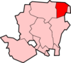 Blackwater • Blounce • Bramshill • Chandlers Green • Church Crookham • Crondall • Crookham Village • Darby Green • Dogmersfield • Dora's Green • Eversley • Eversley Centre • Eversley Cross • Ewshot • Fleet • Frogmore • Greywell • Hartfordbridge • Hartley Wespall • Hartley Wintney • Hawley • Hazeley • Heckfield • Heckfield Heath • Hook • Hook Common • Hound Green • Long Sutton • Lower Common • Mattingley • Mill Lane • Minley • North Warnborough • Odiham • Phoenix Green • Rotherwick • Rye • South Warnborough • Warnborough Green • Well • West Green • Whitehall • Winchfield • Winchfield Green • YateleyCategories:
- Places in Hart (district)
- Villages in Hampshire


Wikimedia Foundation. 2010.