- Cranberry Lake
-
This article is about the lake in New York. For various lakes in Nova Scotia, see Cranberry Lake (Nova Scotia).
Cranberry Lake 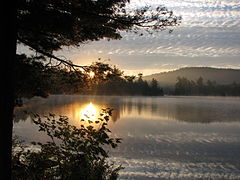
Black Duck Hole, Cranberry Lake Location St. Lawrence County, New York, USA Coordinates 44°10′20″N 074°49′26″W / 44.17222°N 74.82389°WCoordinates: 44°10′20″N 074°49′26″W / 44.17222°N 74.82389°W Primary inflows Oswegatchie River Primary outflows Oswegatchie River Basin countries United States Max. length 8.6 mi (13.8 km) Max. width 3.8 mi (6.1 km) Surface area 6,975 acres (2,823 ha) Average depth 6 ft (1.8 m) Max. depth 38 ft (12 m) Shore length1 55 mi (89 km) Surface elevation 1,480 ft (450 m) Islands Joe Indian Island, Buck Island Settlements Cranberry Lake, Wanakena 1 Shore length is not a well-defined measure. Cranberry Lake is a lake on the Oswegatchie River in the Adirondack Park in New York in the United States. It is the third largest lake in the Adirondack Park (after Lake George and the Great Sacandaga Lake. About 75 percent of the shoreline is owned by State of New York; the 118,000-acre (480 km2) Five Ponds Wilderness Area abuts its south shore, and the Cranberry Lake Wild Forest covers much of its remaining shoreline.
Most of the lake is in the eastern end of the Town of Clifton, but a small part of the east side of the lake is in the Town of Piercefield and a small part of the west side of the lake is in the Town of Fine. The lake is entirely in the south part of Saint Lawrence County, New York.
 View from Bear Mountain lookout over Cranberry Lake
A peninsula jutting into the lake from the north contains Bear Mountain and state camping facilities. One end of the Bear Mountain Trail leaves from campsite loop 3. The other end, a trail head with plenty of good parking, is located much closer to the campground entrance. The hike is fairly rigorous, but from start to the top it is only about 1-mile (1.6 km). The lookout spot near the top provides a great view to the south and south west, mainly of Joe Indian and Buck islands (see below). To the west of the peninsula, on a north arm of the lake is the community of Cranberry Lake. On a western arm of the lake in the Town of Fine, is the community of Wanakena. Wanakena is the location of the New York State Ranger School.
Several islands are within the lake, the largest being Joe Indian Island and Buck Island. The Cranberry Lake Biological Station is located on Barber Point and is part of the State University of New York College of Environmental Science and Forestry. There are several private camps on the southern shore, including on a piece of land called, "Chair Rock". A large rock near there at Barber Point Bio Station bears an engraved memorial for Reuben Wood, designer of fishing flies and politician. There also exists a large camp setting called Wildcliff Lodge (formerly "Hoppies" and then "Verns") that used to have an inn, bar and restaurant. The dining room was actually the former one room log cabin of hermit, "Philo Scott" of Big Deer Pond. It is now closed. Chair Rock Lodge was another popular dining and lodging establishment on the South Shore. It, too, is closed.
History
The lake was named for the extensive cranberry bogs that it once contained. In 1865, the state authorized the building of a dam on the Oswegatchie that doubled the lake's surface area and killed thousands of trees, the stumps of which still remain in some areas. In 1902, the Rich Bros. Lumber Co. purchased 16,000 acres (65 km2) on the southwestern shore of Cranberry Lake, and constructed a lumber mill. Housing for the millworkers was built in part from lumber salvaged from the company's abandoned Pennsylvania lumber operation. There were up to 1500 workers at the Rich mill and associated industries.
A logging railroad was constructed connecting Wanakena to the Carthage and Adirondack Railroad at Benson Mines, starting operation in 1905. The railroad allowed tourists easy access to the area. In 1913, a second railroad was built by the Emporium Lumber Company, connecting Cranberry Lake to the New York Central Railroad.
The Rich Bros. Lumber Co. donated 1,800 acres (7.3 km2) in the vicinity of Cranberry Lake to the New York State Ranger School in 1912. Businessman Charles L. Pack donated 1,000 acres (4.0 km2) of what today is the Cranberry Lake Biological Station to the New York State College of Forestry in 1923. Six years later, in 1929, the International Paper Company donated 500 acres (2.0 km2) to the Ranger School.[1] By 1940, the state had purchased most of the remaining lands of the former lumber companies.[2]
References
- ^ Reznikoff, Charles, ed. 1957. Louis Marshall: Champion of Liberty. Selected Papers and Correspondence. Philadelphia: Jewish Publication Society of America, p. 1123
- ^ Google books: Smeby, Susan Thomas, Cranberry Lake and Wanakena, Arcadia Publishing, 2002 ISBN 0738509698
External links
Categories:- Lakes of New York
- State University of New York College of Environmental Science and Forestry
- Protected areas of St. Lawrence County, New York
- New York State College of Forestry


Wikimedia Foundation. 2010.