- Overbrook Park, Philadelphia, Pennsylvania
-
Overbrook Park is a neighborhood in the West Philadelphia section of Philadelphia, Pennsylvania, United States. It was founded in the 1940s on the site of a former farm, offering new housing for returning GIs and their families. Today, Overbrook Park's population is predominantly black, originally it was largely Jewish.
Contents
Boundaries
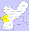
Overbrook Park is bounded by Overbrook on one side, Penn Wynne on another side, Indian Creek (a tributary of Cobbs Creek) and park land on a third side, and a golf course on the fourth side. The main artery is Haverford Avenue which goes into Penn Wynne across City Line Avenue where it becomes Haverford Road. Haverford Avenue and 75th Street connect it to Lansdowne Avenue on the Overbrook side. Haverford Avenue, 76th Street, and 77th Street connect it to City Line Avenue on the Penn Wynne side. The neighborhood spans for approximately four city blocks west to east along City Avenue, and approximately ten smaller blocks north to south on either side of 76th Street. There is a K-12 public school named after Robert Eneas Lamberton, a former Republican mayor of Philadelphia. It is located at 75th and Woodbine.
Population
Overbrook Park used to have a large Jewish population.[1] There was an Orthodox and a Conservative synagogue. Most of the Jews have moved across City Line Avenue (U.S. 1) into neighboring Penn Wynne in Lower Merion Township. The Jewish community of both sides of the border are considered to be one unit and are connected by an eruv, a wire attached to the telephone and electric poles which allows religious Jews to carry things on Shabbat.[2]
The Orthodox Congregation Beth Hamedrosh was founded in the late 1950s as a branch of Beth Hamedrosh HaGadol in West Philadelphia. The congregation moved to Penn Wynne in May 2007, after having purchased the site in 2000.[3] The Building that housed Beth Hamedrosh is now Temple Kefarym, a Black Hebrew congregation.[4]
The Conservative Congregation Beth T'fillah, originally called Overbrook Park Synagogue founded in 1948,[5] closed down in the Fall of 2006 and merged with Adath Israel in Merion, Lower Merion Township due to a lack of sufficient membership.[6] The building that housed Beth T'fillah is now Overbrook Park Church of Christ.
In 1990, Overbrook Park had some 7,200 residents, mostly of Jewish, Italian and Irish origins. During the mid-1990s, whites began to move out of Overbrook Park and the neighborhood started to become majority black. By 2000, the neighborhood's population had become nearly 60% black.[7]
Despite the demographic change, there still are several kosher establishments in Overbrook Park, among them a kosher fish and produce store,[8] a kosher bagel store,[9] a kosher pizzeria, and a kosher bakery.[10]
Overbrook Park is the birthplace of actor Seth Green.[11]
External links
- An interactive aerial perspective photo from Virtual Earth
- Allen Meyers (2001). The Jewish Community of West Philadelphia. Arcadia. ISBN 0-7385-0854-3. http://books.google.ch/books?id=caX_Kb2V0YIC&printsec=frontcover&source=gbs_ge_summary_r&cad=0#v=onepage&q&f=false.
- "A City Transformed. The Racial and Ethnic Changes in Philadelphia Over the Last 20 Years". The Philadelphia Research Initiative. June 1, 2011. http://www.pewtrusts.org/uploadedFiles/wwwpewtrustsorg/Reports/Philadelphia_Research_Initiative/Philadelphia-Population-Ethnic-Changes.pdf/.
References
- ^ William Labov (2001). Principles of linguistic change: Social factors, Volume 2. Language in society. Wiley-Blackwell. ISBN 0-631-17916-X. http://books.google.ch/books?id=LS_Ux3CEI5QC&printsec=frontcover&source=gbs_ge_summary_r&cad=0#v=onepage&q&f=false.
- ^ "Building "Keruv". The Main Line Eruv". The Philadelphia Jewish Voice. September 2006. http://www.pjvoice.com/v15/15608keruv.html.
- ^ "Torah Scrolls Brought to New Home of Beth Hamedrosh". The Philadelphia Jewish Voice. July 2007. http://www.pjvoice.com/v25/25600community.aspx.
- ^ Julian H. Preisler (2008). Historic Synagogues of Philadelphia & the Delaware Valley. The History Press. pp. 47, 48, 102. ISBN 978-1-59629-572-8. http://books.google.ch/books?id=2UvlpOPBes8C&dq=overbrook+park&pg=PA47&source=gbs_navlinks_s#v=onepage&q=overbrook%20park&f=false.
- ^ Julian H. Preisler (2008). Historic Synagogues of Philadelphia & the Delaware Valley. The History Press. p. 52. ISBN 978-1-59629-572-8. http://books.google.ch/books?id=2UvlpOPBes8C&dq=overbrook+park&pg=PA52&source=gbs_navlinks_s#v=onepage&q=overbrook%20park&f=false.
- ^ "CJC Seeks CJC for a Serious Long-term Relationship". The Philadelphia Jewish Voice. October 2005. http://www.pjvoice.com/v4/434merger.html.
- ^ "Overbrookpark". Jewocity.com. http://184.82.180.140/index.php.
- ^ "The Kosher Table: R&R Produce and Fish". The Philadelphia Jewish Voice. February 2006. http://www.pjvoice.com/v8/8901rr.html.
- ^ "The Kosher Table: New York Bagel Bakery". The Philadelphia Jewish Voice. February 2006. http://www.pjvoice.com/v8/8902bagel.html.
- ^ "Kosher Establishments in Philadelphia, PA". Kosher Delight. http://www.kosherdelight.com/PennsylvaniaPhiladelphiaKosherEstablishments.shtml.
- ^ Seth Green at the Internet Movie Database
Coordinates: 39°58′32″N 75°15′55″W / 39.97560°N 75.26533°W
Neighborhoods of the West Philadelphia section of Philadelphia, Pennsylvania Belmont • Belmont Village • Carroll Park • Cathedral Park • Cedar Park • Cobbs Creek • Dunlap • Garden Court • Haddington • Haverford North • Mantua • Mill Creek • Overbrook • Overbrook Farms • Overbrook Park • Parkside • Powelton Village • Saunders Park • Spruce Hill • Squirrel Hill • University City • Walnut Hill • Woodland Terrace • Wynnefield • Wynnefield Heights
 Categories:
- Neighborhoods in Philadelphia, Pennsylvania
- Populated places in Pennsylvania with African American majority populations

Wikimedia Foundation. 2010.