- Ring Neighborhoods, Jerusalem
-
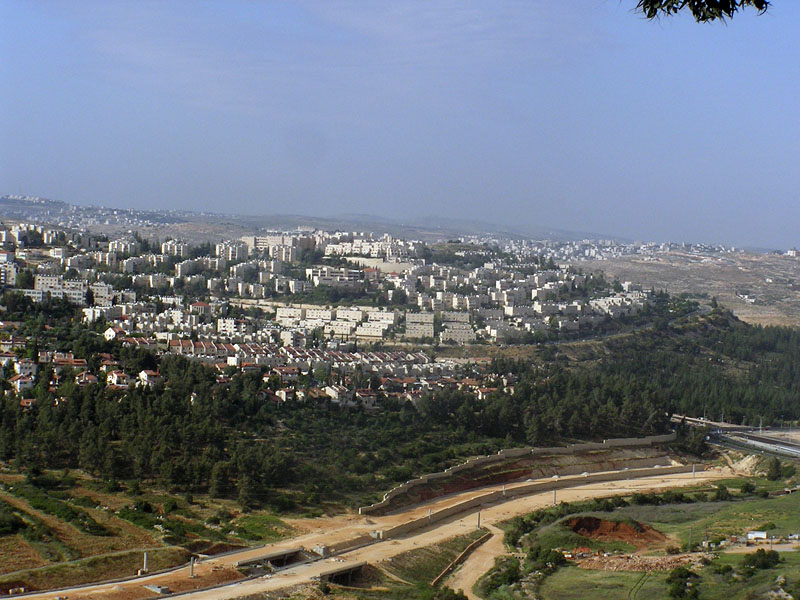
 View of Ramot
The Ring neighborhoods of Jerusalem (Hebrew: שכונות הטבעת) are seven suburban neighborhoods in East Jerusalem. The neighborhoods (more or less clockwise from north to east to south) are Ramot, Ramat Shlomo, Neve Yaakov, Pisgat Ze'ev, East Talpiot, Har Homa and Gilo. The international community does not recognize Israeli sovereignty over East Jerusalem and considers the neighborhoods illegal settlements, but the Israeli government disputes this.[1]
History and legal status
In 1967, following the Six Day War, the makeup of Jerusalem was altered. Plans were drawn up to establish new residential neighborhoods on undeveloped land around Jerusalem as a housing solution for young couples, new immigrants, and middle class families seeking a better quality of life. The city's territory was increased to 108km² when Israel unilaterally annexed areas north, east and south of the city to Israel, totaling an area three times the size of pre-war West Jerusalem. Today, as many as 165,000 people reside in these communities. According to the United Nations and European Union,[2] due to their having been built beyond the Green Line, the neighborhoods Israel subsequently built on these annexed grounds are considered to be Israeli settlements, leading them to be to considered illegal under international law based on the Fourth Geneva Convention and United Nations Security Council Resolution 476.[3][4][5] However, Israel disputes this, maintaining that these neighborhoods are part of the municipality of Jerusalem, and therefore under Israel's sovereignty. The United States position has been inconsistent. The United States abstained from voting on Resolution 476 and the US Congress has declared that "Jerusalem should remain an undivided city... the capital of the State of Israel" in the Jerusalem Embassy Act.[6] On the other hand, the Obama administration has stated that East Jerusalem settlements must halt construction and expansion permanently.[7] Canada has also shown wavering stances regarding the neighborhoods,[8] by using ambiguous wording or refusing to outwardly classify the neighborhoods as illegal West Bank settlements.
Neighborhoods
- Ramot is located at north-west, north of Highway 1. Established in 1974, it has about 50,000 residents as of 2010.
- Ramat Shlomo, due north of downtown was established in 1995. It has an almost entirely Haredi population of 20,000.
- Neve Yaakov is the northernmost neighborhood in Jerusalem. Established in 1970, it has about 30,000 residents.
- Pisgat Ze'ev in the north is the largest neighborhood in Jerusalem. Established in 1982, it has about 50,000 residents.
- East Talpiot (East of Talpiot) is located on the eastern edge of the city, situated near the Commissioner's Palace. Established in 1973, it has about 15,000 residents.
- Har Homa in the far south-east was established in 1997. It has about 20,000 residents.
- Gilo at the south-west of the city, is the highest neighborhood. Established in 1971, it has about 40,000 residents.
Other Jewish neighborhoods in Jerusalem that were built over the Green Line, such as Ramat Eshkol (the first to be built) and French Hill, are not considered to be part of the Ring neighborhoods.
References
- ^ "The Geneva Convention". BBC News. 10 December 2009. http://news.bbc.co.uk/2/hi/middle_east/1682640.stm. Retrieved 27 November 2010.
- ^ EU rebukes Israel for Jerusalem settlement expansion (EUObserver, November 19, 2009)
"The presidency recalls that settlement activities, house demolitions and evictions in East Jerusalem are illegal under international law." - ^ Resolution 476
- ^ SMH.com.au
- ^ A Palestinian Academic Society for the Study of International Affairs study notes (citing from another analysis) that "'since 1967, two rings of new residential neighborhoods built around the city center have created new ramparts [emphasis original] designed primarily as a political barrier against any possible repatriation of the city.'" And concludes that: "the strategic placement of these four settlements formed the key links of the inner ring of settlements between East Jerusalem and the West Bank. Passia.org
- ^ Jewishvirtuallibrary.org
- ^ Analysis: Obama's press on Gilo shows a continued misread of Israel (Jerusalem Post, November 19, 2009)
- ^ Thestar.com
Neighborhoods of Jerusalem Old City 
East Jerusalem American Colony • Al Bustan • Al-Issawiya • At-Tur • Bab a-Zahara • Beit Hanina • Jabel Mukaber • Ma'ale ha-Zeitim • Nachalat Shimon • Nof Zion • Ras al-Amud • Sheikh Jarrah • Shimon HaTzadik • Shuafat • Silwan • Sur Baher • Umm Tuba • Wadi al-JozHaredi neighborhoods Batei Munkatch • Batei Ungarin • Beit Yisrael • Ezrat Torah • Geula • Givat Shaul • Har Nof • Kerem Avraham • Kiryat Belz • Kiryat Mattersdorf • Kiryat Sanz • Kiryat Shomrei Emunim • Machanayim • Mea Shearim • Mekor Baruch • Nachalat Ya'akov • Ramat Shlomo • Ramot Polin • Sanhedria • Sanhedria Murhevet • Sha'arei Hesed • Shmuel HaNavi • Tel Arza • Unsdorf • Zikhron MosheCentral Neighborhoods Batei Nissan Bak • Beit David • Beit Ya'akov • Bukharan neighborhood • Even Yisrael • Ezrat Yisrael • Givat Ram • Katamon • Kiryat Shmuel • Kiryat Wolfson • Mahane Israel • Mahane Yehuda • Merhavia • Mishkenot Sha'ananim • Musrara • Nachalat Achim • Nachlaot • Nayot • Neve Sha'anan • Ohel Shlomo • Rehavia • Yemin MosheNorthern Neighborhoods French Hill • Givat HaMivtar • Ma'alot Dafna • Neve Yaakov • Pisgat Ze'ev • Ramat Eshkol • Ramot • Ramot PolinSouthern Neighborhoods Abu Tor • Baka • Beit Safafa • East Talpiot • The German Colony • Gilo • Givat HaMatos • Greek colony • Har Homa • Mekor Chaim • Ramat Rachel • TalpiotWestern Neighborhoods Bayit VeGan • Beit HaKerem • Givat Massuah • Givat Mordechai • Givat Oranim • Har Hotzvim • Ir Ganim • Katamonim • Kiryat HaYovel • Kiryat Menachem • Kiryat Moshe • Malha • Motza • Pat • Ramat Beit HaKerem • Ramat Denya • Ramat Sharett • Romema • Yefeh NofHistoric Neighborhoods See also: Ring Neighborhoods Categories:- Neighbourhoods of Jerusalem
- Israeli settlements

Wikimedia Foundation. 2010.