- M-20 (Michigan highway)
-
This article is about the state highway in Michigan; for other uses, see M20 (disambiguation)
M-20

M-20 highlighted in redRoute information Maintained by MDOT Length: 132.435 mi[1] (213.133 km) History: ca. July 1, 1919 – November 11, 1926 on previous route
November 11, 1926 – present on current routeMajor junctions West end:  US 31 near New Era
 M-37 in White Cloud
 US 131 near Big Rapids
 M-66 in Remus
 US 127 in Mount Pleasant
East end: 

 US 10 / BUS US 10 in Midland
Location Counties: Oceana, Newaygo, Mecosta, Isabella, Midland, Bay Highway system Michigan State Trunkline Highway System
Interstate • US • State←  M-19
M-19M-21  →
→M-20 is a state trunkline highway in the US state of Michigan that runs from New Era to Midland. It crosses through rural Lower Peninsula forest land between the two ends. The highway serves the college towns of Big Rapids and Mt. Pleasant, home of the main campuses of Ferris State University and Central Michigan University, both located near the trunkline.
Originally in July 1919, M-20 was routed farther north along a corridor now used by US Highway 10 (US 10). The M-20 designation was shifted south to the corridor it now follows. It previously connected to Bay City, and in 1958, a freeway was opened from Bay City to Midland. The former M-20 along Midland Road, going through Auburn, was returned to local control at that time. In 1960, the M-20 freeway became US 10, moving M-20's terminus to Midland. Prior to 1969, M-20 extended on the west end to Muskegon before it was rerouted from White Cloud to New Era.
Contents
Route description
M-20 starts near Lake Michigan at the US 31 freeway in New Era where it runs east through the Manistee National Forest, crossing the North Branch of the White River near Ferry and the South Branch near Hesperia on the way to White Cloud.[2] There it turns south along M-37 and then east along a new routing following Baseline and Newcosta roads north of the Hardy Dam to meet the US 131 freeway at exit 131 near Stanwood. M-20 turns north, running concurrently along the US 131 freeway to Big Rapids and joins Business US 131 (BUS US 131) at exit 139.[2][3] The section along the freeway is listed on the National Highway System (NHS), a system of highways important to the nation's economy, defense and mobility.[4] Together BUS US 131/M-20 runs along the Perry Street commercial corridor to State Street near the main campus of Ferris State University. The business loop turns north by the campus and at Michigan Street, M-20 turns eastward to cross the Muskegon River in downtown Big Rapids, north of the campus. M-20 zig-zags southeast of town bypassing the Canadian Lakes area and turns due east through rural Remus in Isabella County and the Isabella Indian Reservation.[2][3]
In Mt. Pleasant, M-20 runs near the campus of Central Michigan University crossing the Chippewa River, and the trunkline joins BUS US 127 along the Mission Street business area to Pickard Road. The highway turns turns east on Pickard and passes under the US 127 freeway near the Soaring Eagle Casino. From Mt. Pleasant to Midland, M-20 is designed as a four–lane highway with a continuous center turn lane passing through rural forest land.[2][3] M-20 picks up inclusion on the NHS from this point east.[4]
Once M-20 reaches Midland on Jerome Street, it crosses the Tittabawassee River north of the Tridge, a three-legged bridge over the confluence of the Tittabawassee and Chippewa rivers. There it joins Business US 10 (BUS US 10) on a pair of one-way streets: Indian Street (westbound) and Buttles Street (eastbound). The two streets pass by Dow Diamond, home to the Great Lakes Loons, the city's minor league baseball team. BUS US 10/M-20 then passes some Dow Chemical Company buildings and curves into a freeway stub connecting with the US 10 freeway on the east side of town. This short section of business loop freeway has two interchanges before terminating at one final interchange. At this junction, both BUS US 10 and M-20 have a common eastern terminus. Traffic headed eastbound on the business loop defaults onto eastbound US 10, and traffic destined for the business loop is fed from the westbound direction of the freeway only.[2][3]
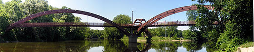 The Tridge in downtown Midland
History
Previous designation
On July 1, 1919, M-20 was routed from Ludington to Bay City, Michigan by way of Reed City and Clare.[5] This routing was redesignated as US 10 on November 11, 1926.[6] M-20 would be moved to a new routing.[7]
Current designation
The M-20 designation was moved to a new alignment, roughly today's current routing from Midland through Mt. Pleasant, Big Rapids and White Cloud continuing to Muskegon.[7] The western terminus was extended to end at Muskegon State Park in 1932.[8][9] The last paving would be completed along M-20 in 1957 in Newaygo County.[10][11]
 M-213 marker
The eastern end of M-20 was converted to freeway between Midland and Bay City in 1958. The former alignment along Midland Road, from Midland, going through Auburn, and ending at Euclid Avenue in Bay City, at the junction of what was then US 23, was returned to local control at the time.[11][12] US 10 was rerouted along this freeway section and the I-75/US 23 freeway in 1960. M-20 was truncated back to Midland with the US 10 rerouting.[13] The west end was rerouted through Muskegon to end at US 16 in 1961.[14] The former routing connecting to Muskegon State Park became a new M-213 until it was removed from the trunkline system in 1970.[15][16] M-20 was completely rerouted on the west end in 1969 from White Cloud replacing M-82 to US 31 in New Era.[15][17]
The Michigan Department of Transportation (MDOT) swapped jurisdiction of M-20 and B-88 with Mecosta and Newaygo counties. The swap was finalized on October 1, 1998.[18] M-20 was rerouted south from Big Rapids, along US 131 from exit 139 to exit 131 at Stanwood. There M-20 replaced B-88 westward to M-37.[19]
Major intersections
All exits are unnumbered.
County Location Mile[1] Destinations Notes Oceana Shelby Township 0.000  US 31 / LMCT – Muskegon, Ludington
Exit 140 on US 31 Oceana–Newaygo Hesperia 18.219  M-120 south – Muskegon
M-120 runs along the county line Newaygo Wilcox Township 31.676 M-37 north – Traverse CityNorthern end of M-37 concurrency White Cloud 32.948 M-37 south – Grand RapidsSouthern end of M-37 concurrency Mecosta Mecosta Township 48.364 US 131 south – Grand RapidsExit 131 on US 131; southern end of US 131 concurrency Big Rapids Township 55.814 


US 131 north / BUS US 131 north (Perry Street) – Reed City, Big RapidsExit 138 on US 131; northern end of US 131 concurrency; western end of BUS US 131 concurrency Big Rapids 58.419
BUS US 131 north (Michigan Avenue)Eastern end of BUS US 131 concurrency Remus 81.814 M-66 – Lake City, IoniaIsabella Mt. Pleasant 100.767
BUS US 127 south (Mission Street)Southern end of BUS US 127 concurrency 101.776
BUS US 127 north (Mission Street)Northern end of BUS US 127 concurrency Union Charter Township 103.244 US 127 – Clare, LansingExit 143 on US 127 Midland Homer Township –
Lee Township121.781  M-30 north (Meridian Road)
Midland 128.088
BUS US 10 westWestern terminus of BUS US 10 concurency 129.830 Freeway begins 130.101 Saginaw Road Interchange 131.272 Waldo Road Interchange; westbound exit and eastbound entrance Bay Williams Township 132.435
BUS US 10 west
US 10 – Clare, Bay CityEastern terminus of BUS US 10 & M-20; eastbound exit and westbound entrance 1.000 mi = 1.609 km; 1.000 km = 0.621 mi
Concurrency terminus • Closed/Former • Incomplete access • UnopenedReferences
- ^ a b "MDOT Physical Reference Finder Application". Michigan Department of Transportation. 2009. http://www.mcgi.state.mi.us/prfinder/. Retrieved September 17, 2010.
- ^ a b c d e The Road Atlas. Rand McNally. 2008. pp. 50-51. Section N4–N10.
- ^ a b c d Michigan Department of Transportation (2010). Official Department of Transportation Map (Map). 1 in:15 mi/1 cm:9 km.
- ^ a b Michigan Department of Transportation (April 23, 2006) (PDF). National Highway System, Michigan (Map). http://www.michigan.gov/documents/MDOT_NHS_Statewide_150626_7.pdf. Retrieved October 7, 2008.
- ^ Michigan State Highway Department (1919). State of Michigan: Lower Peninsula (Map). Cartography by MSHD. http://maps.lib.msu.edu/miroadmaps/1919-lp.htm. Retrieved March 2, 2008.
- ^ Bureau of Public Roads (November 11, 1926). United States System of Highways (Map). http://www.okladot.state.ok.us/hqdiv/p-r-div/maps/misc-maps/1926us.pdf. Retrieved May 10, 2008.
- ^ a b Michigan State Highway Department (December 1, 1926). Official Highway Service Map (Map). Cartography by MSHD.
- ^ Michigan State Highway Department (May 1, 1932). Official Michigan Highway Map (Map). Cartography by Rand McNally.
- ^ Michigan State Highway Department (October 1, 1932). Official Michigan Highway Map (Map). Cartography by Rand McNally.
- ^ Michigan State Highway Department (April 1, 1957). 1957 Official Highway Map (Map).
- ^ a b Michigan State Highway Department (October 1, 1957). 1957 Official Highway Map (Map).
- ^ Michigan State Highway Department (1958). Official Highway Map (Map). (Includes all changes through July 1, 1958)
- ^ Michigan State Highway Department (1960). Official Highway Map (Map). (Includes all changes through July 1, 1960)
- ^ Michigan State Highway Department (1961). Official Highway Map (Map). (Includes all changes through July 1, 1961)
- ^ a b Michigan Department of State Highways (1970). Official Highway Map (Map). 1 in:14.5 mi.
- ^ Michigan Department of State Highways (1971). Official Highway Map (Map). 1 in:14.5 mi.
- ^ Michigan Department of State Highways (1969). Official Highway Map (Map). 1 in:14.5 mi. Cartography by H.M. Gousha.
- ^ "MDOT Accepts Responsibility for 120 Miles of Local Roads" (Press release). Michigan Department of Transportation. September 24, 1998. Archived from the original on December 13, 2004. http://web.archive.org/web/20050218114122/www.michigan.gov/mdot/0,1607,7-151-9620_11057-94859--M_1998_9,00.html.
- ^ Michigan Department of Transportation (1999). Michigan Department of Transportation Map (Map). 1 in.:14.5 mi./1 cm.:9 km..
External links
Categories:- State highways in Michigan
- Western Michigan
- U.S. Route 10
- Midland, Michigan
- Transportation in Midland County, Michigan


Wikimedia Foundation. 2010.