- Wuyi Mountains
-
Mount Wuyi * UNESCO World Heritage Site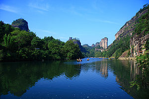
Country  China
ChinaType Mixed Criteria iii, vi, vii, x Reference 911 Region ** Asia-Pacific Inscription history Inscription 1999 (23rd Session) * Name as inscribed on World Heritage List
** Region as classified by UNESCOThe Wuyi Mountains (Chinese: 武夷山; pinyin: Wǔyí Shān; Pe̍h-ōe-jī: Bú-î-soaⁿ) are a mountain range located in the prefecture of Nanping, in the northern border of Fujian province with Jiangxi province, China. The mountains cover an area of 60 km². In 1999, Mount Wuyi entered UNESCO's list of World Heritage Sites,[1] both natural and cultural. It is the most outstanding biodiversity conservation zone of Southeast China.
The Wuyi Mountains are located between Wuyishan City, Nanping prefecture in Fujian province and Wuyishan Town, at Shangrao city in Jiangxi province. The area is connected to the road network by provincial road number S303. The world heritage site has an area of 999.75 square kilometres within an additional buffer zone of 278.88 km².
Numerous types of tea are produced around Mount Wuyi; it is the origin of the real[clarification needed] Da Hong Pao tea and Lapsang souchong, further described in Wuyi tea.
Contents
Environment
Geology
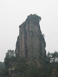 The Yunu hill, the "symbol" of Wuyi Mountains.
The region is part of the Cathayshan fold system and has experienced high volcanic activity and the formation of large fault structures, which were subsequently subject to erosion by water and weathering. The landscape is characterized by winding river valleys flanked by columnar or dome-shaped cliffs as well as cave systems. Peaks in the western portion of the Wuyi Mountains typically consist of volcanic or plutonic rocks, whereas peaks and hills in the eastern area are made up of red sandstone with very steep slopes but flat tops. The Nine-bend River (Jiuqu Xi), about 60 kilometers in length, meanders in a deep gorge among these hills. The highest peak in the area is Mount Huanggang at 2,158 meters, making it the highest point of Fujian, the lowest altitudes are around 200 meters.
Climate
The Wuyi Mountains act as a protective barrier against the inflow of cold air from the northwest and retain warm moist air originating from the sea. As a result, the area has a humid climate (humidity 80 to 85%) with high rainfall (annual average 2,200 millimeters in the south-west and 3,200 millimeters in the north) and common fogs. Lower altitudes experience annual temperatures in the range from 12 to 18 °C.
The area is relatively pollution free. The Chinese government set up its first air quality monitoring station in the area on January 31, 2005. That explains the haze that can be seen in the accompanying photographs.
Biodiversity
Flora
 Forest in the nature reserve portion of the Wuyi Mountains.
The Wuyi Mountains are the largest and most representative example of Chinese subtropical forests and South Chinese rainforests' biodiversity. Its ecology has survived from before the Ice Age around 3 million years ago. Biologists have been conducting field research in the area since 1873.
The vegetation of the area depends strongly on altitude. It is divided into 11 broad categories: 1) temperate coniferous forest, 2) warm coniferous forest, 3) temperate broad-leaved and coniferous mixed forest, 4) deciduous and broad-leaved forest, 5) evergreen broad-leaved and deciduous mixed forest, 6) evergreen broad-leaved forest, 7) bamboo forest, 8) deciduous broad-leaved shrub forest, 9) evergreen broad-leaved shrub forest, 10) brush-wood, and 11) meadow steppe. Most common are evergreen broad-leaved forests, some of which make up the largest remaining tracts of humid sub-tropical forests in the world. Higher plants from 284 families, 1,107 genera and 2,888 species as well as 840 species of lower plant and fungus have been reported for the region. The most common tree families are Beech Fagaceae, Laurel (Lauraceae), Camellia (Theaceae), Magnolia (Magnoliaceae), Elaeocarpaceae, and Witchhazel Hamamelidaceae.
Fauna
 Punting on the River of Nine Bends, Wuyishan, China.
The fauna of the Wuyi Mountains is renowned for its high diversity, which includes many rare and unusual species. In total, approximately 5,000 animal species have been reported for the area. 475 of these species are vertebrates and 4,635 insects. The number of vertebrate species is divided as follows:
families species mammals 23 71 birds 47 256 reptiles 13 73 amphibian 10 35 fish 12 40 49 vertebrate species are endemic to China and 3 are endemic to the Wuyi Mountains. The latter are the bird David's Parrotbill (Paradoxornis davidianus), Pope’s Spiny Toad (Vibrissaphora liui), and the Bamboo Snake Pseudoxenodon karlschmidti (family Colubridae). Other known endangered species in the area include: South Chinese Tiger (Panthera tigris amoyensis), Clouded Leopard (Neofelis nebulosa), Leopard (Panthera pardus), Hairy-fronted Muntjac (Muntiacus crinifrons), Mainland Serow (Capricornis sumatraensis - a goat antelope), Cabot's Tragopan (Tragopan caboti), Chinese Black-backed Pheasant (Syrmaticus ellioti), Chinese Giant Salamander (Andrias davidianus), and the Golden Kaiserihind (Teinopalpus aureus - a Swallowtail Butterfly).
Human history
Human settlement on the slopes of Mount Wuyi can be traced back 4,000 years by archeological remains. During the Western Han Dynasty, the ancient city of Chengcun was the capital of the Minyue kingdom. In the 7th century, the Wuyi Palace was built for emperors to conduct sacrificial activities, a site that tourists can still visit today. The mountains were an important center of Taoism and later Buddhism. Remains of 35 academies erected from the era of the Northern Song to the Qin Dynasty and more than 60 Taoist temples and monasteries have been located. However, most of these remains are very incomplete. Some of the exceptions for which authentic remains are preserved are the Taoyuan Temple, the Wannian Palace, the Sanqing Hall, the Tiancheng Temple, the Baiyun temple, and the Tianxin temple. The area is the cradle of Neo-Confucianism, a current that became very influential since the 11th century.
Tourism
The number of visitors to the area has increased from approximately 424,000 in 1993 to 700,000 in 1998. A raft trip down the Nine-bend River is the most popular activity followed by a visit to the "Thread of Sky" caves, where the narrowest walkway is only 30 cm. Visitor access to the biodiversity protection area is controlled.
References
- ^ Britannica Educational Publishing (2010). The Geography of China: Sacred and Historic Places. The Rosen Publishing Group, Incorporated. pp. 115. ISBN 1615301348. http://books.google.com/books?id=Z-P_u2AIzbEC&pg=PA114&dq=Wuyi+Mountains&hl=en&ei=_ws1TobTA8ao8AOv5cCgDg&sa=X&oi=book_result&ct=book-preview-link&resnum=2&ved=0CEYQuwUwAQ#v=onepage&q=Wuyi%20Mountains&f=false.
External links
- Guide to Wuyi
- Evaluation by UNESCO advisory board (1999)
- Description of natural features
- Photo Gallery
Mountain ranges of China Geography of China Ailao Mountains · Altai Mountains · Argu Tagh · Changbai Mountains · Daba Mountains · Dabie Mountains · Dalou Mountains · Daxue Mountains · Dzungarian Alatau · Greater Khingan · Helan Mountains · Hengduan Mountains · Himalayas · Jiuling Mountains · Jiuyi Mountains · Karakoram · Kunlun Mountains · Lesser Khingan · Luoxiao Mountains · Lüliang Mountains · Huangshan · Jingshan Mountains · Mount Lang · Min Mountains · Mufu Mountains · Nanling Mountains · Pamir Mountains · Qian Mountains · Qin Mountains · Qionglai Mountains · Taihang Mountains · Tarbagatai Mountains · Tian Shan · Tanggula Mountains · Wanda Mountains · Wudang Mountains · Wuling Mountains · Wuyi Mountains · Xuefeng Mountains · Yengisogat · Yin Mountains · Yunling Mountains · Zhongtiao Mountains Landforms of China
World Heritage Sites in China East Classical Gardens of Suzhou · Fujian Tulou · Lushan National Park · Mount Huang (Huangshan) · Mount Sanqing (Sanqingshan) · Mount Tai (Taishan) · Mount Wuyi (Wuyishan) · Temple and Cemetery of Confucius and Kong Family Mansion, Qufu · Ancient villages in Southern Anhui - Xidi and Hongcun · West Lake Cultural Landscape of Hangzhou

South Central Ancient Building Complex in the Wudang Mountains · Historic Centre of Macau · Kaiping Diaolou and Villages · Longmen Grottoes · Historic Monuments of Dengfeng, including the Shaolin Monastery and Gaocheng Observatory · Wulingyuan Scenic and Historic Interest Area · Yin Xu
Southwest Dazu Rock Carvings · Historic Ensemble of the Potala Palace, including the Jokhang and Norbulingka · Huanglong Scenic and Historic Interest Area · Jiuzhaigou Valley Scenic and Historic Interest Area · Old Town of Lijiang · Mount Emei Scenic Area, including Leshan Giant Buddha Scenic Area · Mount Qingcheng and the Dujiangyan Irrigation System · Sichuan Giant Panda Sanctuaries · Three Parallel Rivers of Yunnan Protected Areas
North Mount Wutai (Wutaishan) · Chengde Mountain Resort and its outlying temples including the Putuo Zongcheng Temple, Xumi Fushou Temple and the Puning Temple · Imperial Palaces of the Ming and Qing Dynasties in Beijing and Shenyang · Peking Man Site at Zhoukoudian · Ancient City of Pingyao · Summer Palace, an Imperial Garden in Beijing · Temple of Heaven: an Imperial Sacrificial Altar in Beijing · Yungang Grottoes
Northeast Capital Cities and Tombs of the Ancient Koguryo Kingdom · Imperial Palaces of the Ming and Qing Dynasties in Beijing and Shenyang
Northwest Multiple regions Fujian topics Fuzhou (capital) General Geography Cities • Jiulong River • Min River • Wuyi Mountains • East China Sea • South China Sea • Haitan IslandEducation Huaqiao University • Xiamen University • Jimei University • Xiamen University of Technology • Longyan University • Putian UniversityCulture Cuisine Visitor attractions Jiangxi topics Nanchang (capital) General Geography Cities • Mufu Mountains • Jiuling Mountains • Luoxiao Mountains • Wuyi Mountains • Gan River • Lake Poyang • Yangtze River • Xiushui RiverEducation Jiangxi Normal University • Jiangxi Science and Technology Normal University • Jiangxi Agricultural University • Nanchang UniversityCulture Nanchang dialect • Yichun dialect • Ganju opera • Hakka dialect • Hakka architecture • Taoism • CuisineVisitor attractions Categories:- Mountain ranges of China
- National parks of China
- Biosphere reserves of China
- World Heritage Sites in China
- Geography of Fujian
- Visitor attractions in Fujian


Wikimedia Foundation. 2010.