- Sejerø
Geobox Settlement
name = Sejerø Island
native_name =
other_name =
other_name1 =
category = Island
image_size = 255px
image_caption =
flag_size =
symbol =
symbol_size = 90px
country = Denmark | state=
region =
district =Samsø municipality ?
district_type = Municipality | district_label=
part_type = | part_count =
part = | part1 =
area = 12.36
area_round = 0
location =
lat_d = 55 | lat_m = 53 | lat_s = 0 | lat_NS= N
long_d= 11 | long_m= 9 | long_s= 0 | long_EW= E
elevation =
population_as_of = 2006
population = 400 | population_density=
established_type =
established =
established1_type =
mayor =
timezone = CET
utc_offset = +1
timezone_DST = CEST
utc_offset_DST= +2
postal_code = 4592 [Postal website www.Postnumre.dk.]
postal_code_type = Postal codes
area_code = | area_code_type=
free_type = | free=
free1_type = | free1=
 map_size=
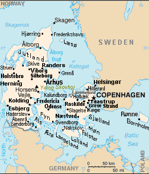
map_caption = Sejerø island (left center) is east ofHorsens
map_locator =
map_locator_x = 43.8
map_locator_y = 61.5
website =Sejerø is a Danish island in the
Kattegat close toZealand . [ "VESTSJAELLAND DENMARK Geography Population" (coordinates), Tageo.com, 2007, webpage: [http://www.tageo.com/index-e-da-v-14-d-m3816540.htm Tageo-Sejero] .] The island covers an area of 12,36 km² (5 square miles) and has 400 inhabitants. The largest village on Sejerø isSejerby , with half of the island's population.[
 Sejerø island (top center) is west of Zealand island, east of
 Samsø .]ee also
*
Samsø ,Zealand - nearby islands.Notes
References
* Tageo.com, "VESTSJAELLAND DENMARK Geography Population" (coordinates), 2007, webpage: [http://www.tageo.com/index-e-da-v-14-d-m3816540.htm Tageo-Sejero] .
* Denmark Postal codes, webpage: [http://www.postnumre.dk/ Postnumre-DK] .
* Tele.dk Denmark detailed road map, webpage: [http://home6.inet.tele.dk/vlh/danmark.jpgTele-DK-Danmark] .
Wikimedia Foundation. 2010.