- Oxelaëre
-
Oxelaëre
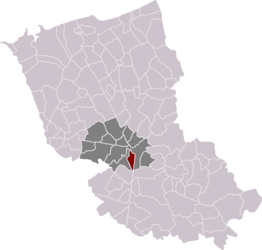
Location within the arrondissement of Dunkerque 
 OxelaëreLocation within Nord-Pas-de-Calais region
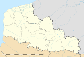 Oxelaëre
Administration Country France Region Nord-Pas-de-Calais Department Nord Arrondissement Dunkerque Canton Cassel Intercommunality pays de Cassel Mayor Stéphane Dieusaert
(2008–2014)Statistics Elevation 29–103 m (95–338 ft)
(avg. 36 m/118 ft)Land area1 4.72 km2 (1.82 sq mi) Population2 362 (1999) - Density 77 /km2 (200 /sq mi) INSEE/Postal code 59454/ 59670 1 French Land Register data, which excludes lakes, ponds, glaciers > 1 km² (0.386 sq mi or 247 acres) and river estuaries. 2 Population without double counting: residents of multiple communes (e.g., students and military personnel) only counted once. Coordinates: 50°47′22″N 2°28′24″E / 50.7894°N 2.4733°E
Oxelaëre is a commune in the Nord department in northern France.
Heraldry
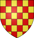
The arms of Oxelaëre are blazoned :
Chequy Or and gules. (Oxelaëre, Quesnoy-sur-Deûle and Sars-et-Rosières use the same arms)See also
References
Categories:- Communes of Nord
- Nord geography stubs


Wikimedia Foundation. 2010.