- Counties of Ireland
-
The counties of Ireland (Irish: contaetha na hÉireann) are sub-national divisions used for the purposes of administrative, geographical and political demarcation. By the early 17th century all of Ireland had been divided into counties. The older term "shire" was historically equivalent to "county". These land divisions were formed following the Norman invasion in imitation of the units of local government then in use in England.[1].
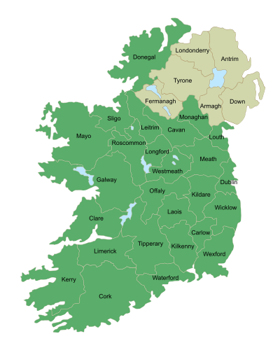 Click on a county to go to the corresponding article
In partitioning Ireland in 1921, the county was the basic land division employed.
With the waning of the power of the barons, new offices of political control came to be established at a county level. Since the early 19th century counties have been adapted to meet new administrative and political requirements, and the word "county" has been used in different senses for different purposes. The counties of Northern Ireland are no longer used for local government; Districts are instead used. While they are still in use for local government purposes in the Republic of Ireland, they have been supplemented by city councils with equivalent powers in the major population centres.
Contents
Interactive map and usage
In Ireland, the usage of the word county nearly always comes before rather than after the county name; thus "County Clare" in Ireland as opposed to "Clare County" in Michigan, U.S.A. The former "King's County" and "Queen's County" were exceptions; these are now County Offaly and County Laois, respectively. The abbreviation Co. is used, as in "Co. Clare". The synonym shire is not used for Irish counties, although the Marquessate of Downshire was named in 1789 after County Down.
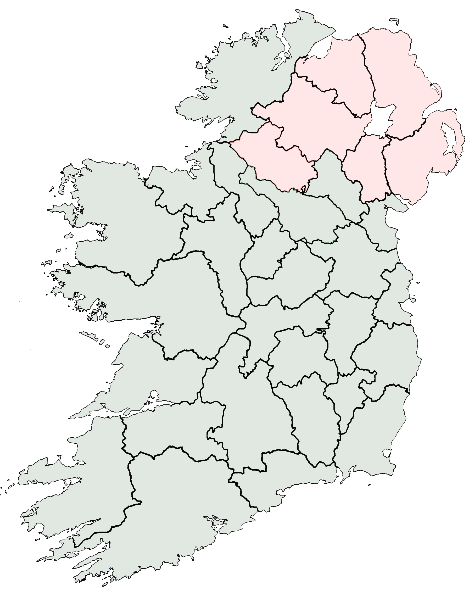
The map at the beginning of this article shows the thirty-two traditional counties that were in place in Ireland by early 17th century. Their area does not always correspond with the area of the counties currently used for local government purposes. The map links to county articles by using an image map, which allows it to be used for navigating the encyclopedia in addition to showing geographic locations. Click on a county to go to the corresponding article. Note: Northern Ireland counties are coloured tan; Londonderry is often called Derry: see Derry-Londonderry name dispute.
History
See also: Early Irish law#KingshipMany counties have their origins in antiquity and the geographic counties that existed prior to the local government reforms of 1836, 1898 and 2001 are sometimes referred to as traditional or historic counties. From 1898 to 2001, areas with county councils were known as administrative counties. In some cases, these administrative counties excluded larger town and cities known as county boroughs. In still other cases, the traditional county was divided to form 2 administrative counties.
Pre-Norman sub-divisions
The political geography of Ireland can be traced with some accuracy from the 6th century. At that time Ireland was divided into a patchwork of petty kingdoms with a fluid political hierarchy which, in general, had three traditional grades of king. The lowest level of political control existed at the level of the called a tuath (pl. tuatha). A tuath was an autonomous group of people of independent political jurisdiction under a Rí túaithe, that is, a local petty king.[2] About one hundred and fifty such units of government existed. Each Rí Tuaithe was in turn subject to a regional or "over-king" Irish: ruiri. There may have been as many as 20 genuine ruiri in Ireland at any time. A "king of over-kings" Irish: rí ruirech was often a provincial (Irish: rí cóicid) or semi-provincial king to whom several ruiri were subordinate. No more than six genuine rí ruirech were ever contemporary. Usually, only five such "king of over-kings" existed contemporaneously and so are described in the Irish annals as fifths (cúigí in Irish). The areas under the control of these kings were : Ulster (Irish: Ulaidh), Leinster (Irish: Laighin), Connacht (Irish: Connachta), Munster (Irish: An Mhumhan) and Mide (Irish: An Mhídhe). Later record-makers dubbed them provinces, in imitation of Roman provinces. In the Norman period, the historic fifths of Leinster and Meath gradually merged, mainly due to the impact of the Pale, which straddled both, thereby forming the present-day province of Leinster. The use of provinces as divisions of political power was supplanted by the system of counties after the Norman invasion. In modern times clusters of counties have been attributed to certain provinces but these clusters have no legal status. They are today seen mainly in a sporting context, as Ireland's four professional rugby teams play under the names of the provinces, and the Gaelic Athletic Association has separate Provincial councils and Provincial championships.
Norman areas of control
Life in Ireland
CultureEconomyGeneralSocietyPoliticsPoliciesWith the arrival of Cambro-Norman knights in 1169, the Norman invasion of Ireland commenced. This was followed in 1172 by the invasion of King Henry II of England, commencing English royal involvement[3]. The English governed Ireland in a like structure as they did themselves, by dividing the country into shires or counties in the late 12th and early 13th centuries.
The counties were made up, in general, from an amalgamation of various smaller Irish territories which suited the colonial administration at the time and had little basis in older tribal boundaries. In many cases this involved dividing an Irish territory in two. For example, the kingdom of Uí Maine was split to form south County Roscommon and most of east County Galway. Many of the counties of Ulster roughly correspond to the territories controlled by the principal clan in that particular area such as the O Donnells of Tír Conaill whose political power was concentrated in what would become the County of Donegal.
The counties evolved over time, with the earliest defined being set out by King John, including a then much larger County Dublin. In the Anglo-Saxon controlled territories, a royal official known as a "shire reeve" or sheriff governed the shire. Large parts in the south east of the island had been shired by the Cambro-Norman overlords by the end of the 13th century. Following the resurgence in the 14th and 15th centuries of the Gaelic nobility, the project was suspended, not to be resumed until the mid 16th century by the House of Tudor. There were two phases in this period under the newly created Kingdom of Ireland: the plantation of the midlands under Mary Tudor and the plantation of Munster under her half-sister Elizabeth. By the reign of King James I & VI, the process was completed with the plantation of the last remaining princely domains in the province of Ulster. With the late addition of County Wicklow, the number of counties (Irish: contae or condae IPA: [ˈkʊndeː]).[4] stood at thirty two. This number remained fixed for a little over 200 years until the division of some counties into smaller entities for judicial purposes (1836), initially, followed by complete division in the 20th and 21st centuries.
By 1200 there were also shires of Connacht, Cork, Kerry, Limerick, Louth and Tipperary. Waterford, Kilkenny and Wexford apparently date from this time, too, as remnants of Strongbow's palatine county in Leinster. The process continued over time, and in 1206, for example, a special commission was used to determine borders in the Munster area.
The County of Roscommon was separated from Connacht before 1292, and the first session of the Irish parliament in 1297 created the new shires of County Kildare, Meath and Ulster. Carlow, then larger than today, and extending to and including coastal Arklow, probably dates from around 1306.[5]
In the 14th century, "Counties of the Cross" emerged, consisting of scattered areas of church land within the existing divisions. Unlike the secular counties (or liberties), the counties of the cross were administered by royally-appointed sheriffs.
Tudor areas of control
The Tudor administrations finalised the division of Ireland into counties. Westmeath was separated from Meath (often East Meath) in 1543. Queen Mary I of England introduced a new policy to pacify the midland areas - plantation. In 1556 King’s County and Queen’s County were created and the Kingdom of Connacht was broken up into the counties of Galway, Mayo and Sligo, while Leitrim was separated from Roscommon in 1565. At the same time County Clare was created and moved from Munster to Connacht, being returned to Munster in 1602.
In 1583 County Longford was formed from part of Westmeath and transferred to the Province of Connacht.[6]
The Province of Ulster was the last to be shired. The counties of Antrim and Down originated early in the 16th century. These were joined in 1584/5 by the Counties of Armagh, Coleraine (later reformed as Londonderry), Donegal, Fermanagh, Monaghan and Tyrone. County Cavan was also formed in 1584 and transferred from Connacht to Ulster.[5]
The last county to be formed was County Wicklow in 1606-1607, taking in the southern part of Dublin (with the exception of three "islands," exclaves of (mainly) church property), and the northern part of "Catherlough" or Carlow, including Arklow.
Former counties
Former counties include: County Coleraine, which formed the basis of County Londonderry, the counties of Nether and Upper Tyrone,[7] and Desmond which was, in 1606, split between counties Cork and Kerry. Other names seen on old maps include Caterlaugh or Caterlagh, archaic designations of County Carlow, in the days before much of the north of that county was taken into Wicklow in the early 17th century.
The Earldom of Ulster consisted not only the counties of Antrim and Down, but also at different times the former counties of; del Art (Ards), Blathewyc (Newtownards), Carrickfergus, Ladcathel (Lecale), and Twescard.[8] Carrickfergus would lose its county town status in 1777. Twescard is preserved as the name of a school house at Campbell College, Belfast.
Exceptions to the county system of control
Regional presidencies of Connacht and Munster remained in existence until 1672, with special powers over their subsidiary counties. Tipperary remained a county palatine until the passing of the County Palatine of Tipperary Act 1715, with different officials and procedures from other counties. At the same time, Dublin, until the 19th century, had ecclesiastical liberties with rules outside those applying to the rest of Dublin city and county. Exclaves of the county of Dublin existed in counties Kildare and Wicklow. At least eight other enclaves of one county inside another, or between two others, existed. The various enclaves and exclaves were merged into neighbouring and surrounding counties, primarily in the mid-19th century under a series of Orders in Council.
19th and 20th century changes
The boundaries of the traditional counties has changed on a number of occasions. As a result of the Local Government (Ireland) Act 1898 changes were made to the boundaries of Counties Galway, Clare, Mayo, Sligo, Waterford, Kilkenny, Meath and Louth, and others. County Tipperary was divided into two regions: North Riding and South Riding. Areas of the cities of Belfast, Cork, Dublin, Limerick, Londonderry and Waterford were carved from their surrounding counties to become county boroughs in their own right and given powers equivalent to those of administrative counties.[9][10][11]
Under the Local Government Provisional Order Confirmation Act 1976, part of the urban area of Drogheda, which lay in County Meath, was transferred to County Louth on 1 January 1977. This resulted in the land area of County Louth increasing slightly at the expense of County Meath.[12] The possibility of a similar action with regard to Waterford City has been raised in recent years, though opposition from Kilkenny has been strong.
Counties as the basis of the division of the Kingdom
Under the Government of Ireland Act 1920, "Home Rule" institutions resulted in the division of Ireland: Southern Ireland and Northern Ireland. The county was the basis of the division with 26 counties forming what would later be known as the Irish Free State and the remaining 6 forming Northern Ireland. This partition was made permanent by the Anglo-Irish Treaty, which was ratified in 1922, by which Ireland left the United Kingdom with Northern Ireland rejoining two days later.
Sub-divisions of counties
To correspond with the subdivisions of the English shires into honors or baronies, Irish counties were granted out to the Anglo-Norman noblemen in cantreds, later known as baronies, which in turn were subdivided, as in England, into civil parishes and townlands. However, in many cases, these divisions correspond to earlier, pre-Norman, divisions. While there are 331[citation needed] baronies in Ireland, and more than a thousand civil parishes, there are around sixty thousand townlands that range in size from one to several thousand hectares. Townlands were often traditionally divided into smaller units called quarters, but these subdivisions are not legally defined.
Evolution of functions
The Church of Ireland exercised functions at the level of civil parish that would later be exercised by county authorities. Vestigial feudal power structures structures of major old estates remained well into the 18th century. Urban corporations operated individual royal charters. Management of counties came to be exercised by grand juries. Members of grand juries were the local payers of rates who historically held judicial functions, taking maintenance roles in regard to roads and bridges, and the collection of "county cess" taxes. They were usually composed of wealthy "country gentlemen" (i.e. landowners, farmers and merchants):
“A country gentleman as a member of a Grand Jury...levied the local taxes, appointed the nephews of his old friends to collect them, and spent them when they were gathered in. He controlled the boards of guardians and appointed the dispensary doctors, regulated the diet of paupers, inflicted fines and administered the law at petty sessions.”[13]
The counties were initially used for judicial purposes, but began to take on some governmental functions in the 17th century, notably with grand juries. In 1836, their use as local government units was further developed, with grand-jury powers extended under the Grand Jury (Ireland) Act 1836. The traditional county of Tipperary was split into two judicial counties (or ridings) following the establishment of assize courts in 1838. Also in that year, local poor law boards, with a mix of magistrates and elected "guardians" took over the health and social welfare functions of the grand juries.
Sixty years later, a more radical reorganisation of local government took place with the passage of the Local Government (Ireland) Act 1898. This Act established a county council for each of the thirty-three Irish administrative counties. Elected county councils took over the powers of the grand juries.
Counties today
Republic of Ireland
Ireland 
This article is part of the series:
Politics and government of
the Republic of IrelandConstitutionJudiciaryDivisionsForeign policy
Main article: Local government in the Republic of IrelandThe twenty-nine counties of the Republic of Ireland number are the basis for local government, planning and community development purposes. Unlike the counties of the United Kingdom, the boundaries of the Republic's twenty-six original counties are still generally respected for other purposes (e.g. divisions of the Gaelic Athletic Association (GAA)). Administrative borders have been altered to allocate various towns (e.g. Bray) exclusively into one county having been originally split between two counties. Six of the twenty-six original counties have more than one local authority resulting in 29 county councils and 5 city councils - a total of 34 local government entities.
- County Tipperary was split into North and South Ridings in 1838. These ridings were established as separate administrative counties under the Local Government (Ireland) Act, 1898. By the terms of the Local Government Act 2001, the counties of North Tipperary and South Tipperary were created.
- County Dublin was abolished as an administrative county in 1994. Its territory was divided into three counties: Dun Laoghaire-Rathdown, Fingal, and South Dublin.
- County Cork was split into an administrative area for the city with another administrative area for the remaining part of the original county.
- County Galway was split into an administrative area for the city with another administrative area for the remaining part of the original county.
- County Limerick was split into an administrative area for the city with another administrative area for the remaining part of the original county.
- County Waterford was split into an administrative area for the city with another administrative area for the remaining part of the original county.
The 5 large population centres are governed by city councils (previously known as corporations) and are administered separately from the counties that surround them. These population centres are Dublin, Cork, Limerick, Galway and Waterford. The city of Kilkenny is the only city in the Republic not to have a "city council"; it is still a borough but not a county borough and is administered by its eponymous county council. It is, however, permitted to retain the style of "city" for ornament only.
These 34 "county-level" entities correspond to the first level of local administrative unit for EU and Eurostat purposes. The second level of local administrative unit (LAU) is the District electoral division. The 2001 Act also provided for the creation of Town councils. Of the administrative structures established under the 1898 Local Government Act, the only type to have been completely abolished was the Rural District, which was rendered void in the early years of the Irish Free State amidst widespread allegations of corruption. At a level above that of LAU is the Region which clusters counties together for NUTS purposes. The Regions are administered by Regional Authorities which were established by the Local Government Act 1991 and came into existence in 1994.
Education
The Vocational Education Committee system was created in 1930. Originally, VECs were formed for each administrative county and county borough, and also in a number of larger towns. In 1997 the majority of town VECs were absorbed by the surrounding county. With the exception of the Dublin area, VEC areas are identical to the local government counties and cities. The separate committees for County Dublin and the former borough of Dún Laoghaire continue to exist.
The institute of technology system was organised on the committee areas or "functional areas", these still remain legal but are not as important as originally envisioned as the institutes are now more national in character and are only really applied today when selecting governing councils, similarly Dublin Institute of Technology was originally a group of several colleges of the City of Dublin committee.
Elections
Where possible, parliamentary constituencies in the Republic of Ireland follow county boundaries. Under the Electoral Act 1997 a Constituency Commission is established following the publication of census figures every five years. The Commission is charged with defining constituency boundaries, and the 1997 Act provides that the breaching of county boundaries shall be avoided as far as practicable.[14] This provision does not apply to the boundaries between cities and counties, or between the three counties in the Dublin area.
This system usually results in more populated counties having several constituencies: Dublin, including Dublin city, is subdivided into twelve constituencies, Cork into five. On the other hand, smaller counties such as Carlow and Kilkenny or Laois and Offaly may be paired to form constituencies. An extreme case is the splitting of Ireland's least populated county of Leitrim between the constituencies of Sligo-North Leitrim and Roscommon-South Leitrim.
Each county or city is divided into Local Electoral Areas for the election of councillors. The boundaries of the areas and the number of councillors assigned are fixed from time to time by order of the Minister for the Environment, Heritage and Local Government, following a report by the Local Government Commission, and based on population changes recorded in the census.[15]
Northern Ireland
Main article: Counties of Northern IrelandIn Northern Ireland, a major re-organisation of local government in 1973 replaced the six traditional counties and two county boroughs (Belfast and Derry) with twenty-six single-tier districts for local government purposes, and these cross the traditional county boundaries. The six counties and two county boroughs remain in use for some purposes, including Lord Lieutenants, vehicle number plates, and the Royal Mail postcode address file.
Other uses
The administrative division of the country along the lines of traditional counties was also adopted by non governmental and cultural organisations such as the Gaelic League and the Gaelic Athletic Association, which continues organises its activities on largely on this basis. GAA county division continue to strong loyalties.
Alphabetical list
Coat of
ArmsTraditional
countyIrish name[16] Ulster-Scots name(s) Older
names and spellingsCounty seat Province Jurisdiction Districts (NI) /
administrative divisions (RoI)
Antrim Aontroim
(Contae Aontroma)Anthrim
Antrìm
Antrim
EntrimAntrim Ulster Northern Ireland Antrim, Ballymena, Ballymoney, Belfast, Carrickfergus, Larne, Lisburn, Moyle, Newtownabbey 
Armagh Ard Mhacha
(Contae Ard Mhacha)Airmagh
ArmaghArdmagh[17] Armagh Ulster Northern Ireland Armagh, Craigavon, Newry & Mourne. 
Carlow Ceatharlach
(Contae Cheatharlach)Caherlagh[18]
Caterlagh[19]
Catherlagh[20]Carlow Leinster Republic of Ireland 
Cavan An Cabhán
(Contae an Chabháin)Cavan Ulster Republic of Ireland 
Clare An Clár
(Contae an Chláir)Ennis
(see Thomond)Munster Republic of Ireland 
Cork Corcaigh
(Contae Chorcaí)(see Desmond) Cork Munster Republic of Ireland City of Cork 
Donegal Dún na nGall
(Contae Dhún na nGall)Dinnygal
DunnygalDunnagall
Tyrconnell
Tirconnell
Tirconaill[21]Lifford Ulster Republic of Ireland 
Down An Dún
(Contae an Dúin)Doon
DounDownshire Downpatrick Ulster Northern Ireland Ards, Banbridge, Castlereagh, Craigavon, Down, Lisburn, Newry & Mourne, North Down 
Dublin Áth Cliath
(Contae Átha Cliath)Dublin Leinster Republic of Ireland City of Dublin, Dun Laoghaire-Rathdown, Fingal, South Dublin 
Fermanagh Fear Manach
(Contae Fhear Manach)Fermanay
FermanaghEnniskillen Ulster Northern Ireland Fermanagh 
Galway Gaillimh
(Contae na Gaillimhe)Gallive[22] Galway Connacht Republic of Ireland City of Galway 
Kerry Ciarraí
(Contae Chiarraí)(see Desmond) Tralee Munster Republic of Ireland Kildare Cill Dara
(Contae Chill Dara)Naas Leinster Republic of Ireland 
Kilkenny Cill Chainnigh
(Contae Chill Chainnigh)Kilkenny Leinster Republic of Ireland 
Laois Laois
(Contae Laoise)Queen's County Portlaoise Leinster Republic of Ireland 
Leitrim Liatroim
(Contae Liatroma)Carrick-on-Shannon Connacht Republic of Ireland Limerick Luimneach
(Contae Luimnigh)Limnigh/Limnagh
Lumnigh/LumnaghLimerick Munster Republic of Ireland City of Limerick 
Londonderry[23] Doire
(Contae Dhoire)Lunnonderrie (see Coleraine) Coleraine Ulster Northern Ireland Coleraine, Cookstown, Derry, Limavady, Magherafelt Longford An Longfort
(Contae an Longfoirt)Longford Leinster Republic of Ireland Louth Lú
(Contae Lú)Dundalk Leinster Republic of Ireland 
Mayo Maigh Eo
(Contae Mhaigh Eo)Maio[24] Castlebar Connacht Republic of Ireland 
Meath An Mhí
(Contae na Mí)Navan
(previously Trim)Leinster Republic of Ireland Monaghan Muineachán
(Contae Mhuineacháin)Monaghan Ulster Republic of Ireland 
Offaly Uíbh Fhailí
(Contae Uíbh Fhailí)King's County Tullamore Leinster Republic of Ireland 
Roscommon Ros Comáin
(Contae Ros Comáin)Roscoman[25] Roscommon Connacht Republic of Ireland 
Sligo Sligeach
(Contae Shligigh)Sligagh[26] Sligo Connacht Republic of Ireland 
Tipperary Tiobraid Árann
(Contae Thiobraid Árann)Clonmel & Nenagh
(previously Cashel & Clonmel)Munster Republic of Ireland North Tipperary, South Tipperary 
Tyrone Tír Eoghain
(Contae Thír Eoghain)Owenslann
TyroneTyrowen
TirowenOmagh Ulster Northern Ireland Cookstown, Dungannon and South Tyrone, Omagh, Strabane Waterford Port Láirge
(Contae Phort Láirge)Portlarga/Portlarge
Portlagh/PortlawDungarvan
(previously Waterford)Munster Republic of Ireland City of Waterford 
Westmeath An Iarmhí
(Contae na hIarmhí)Mullingar Leinster Republic of Ireland 
Wexford Loch Garman
(Contae Loch Garman)Loughgarman[27] Wexford Leinster Republic of Ireland Wicklow Cill Mhantáin
(Contae Chill Mhantáin)Kilmantan[28] Wicklow Leinster Republic of Ireland See also
- List of Irish counties by population
- List of Irish counties by area
- List of Irish county towns
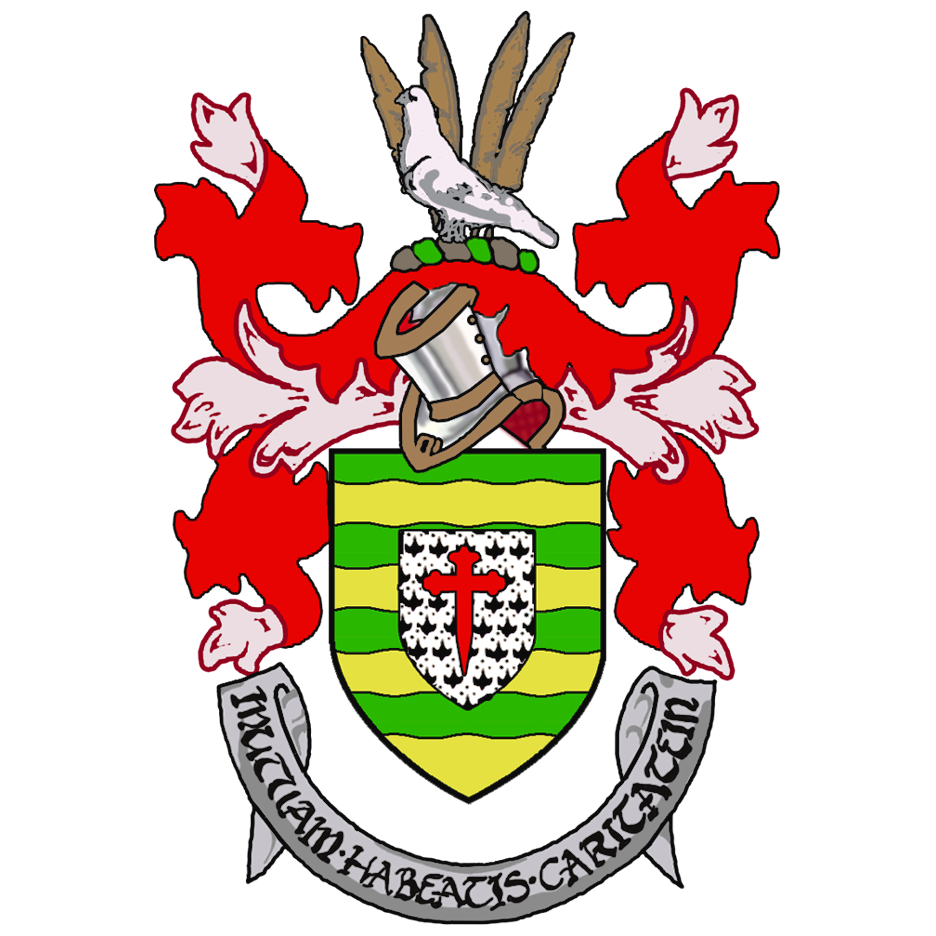
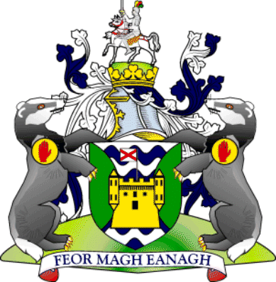
- List of Irish counties' coats of arms
- Irish Vehicle Registration Plates
- GAA county colours
- ISO 3166-2:IE
References and footnotes
- ^ Bryne, T., Local Government in Britain, (1994)
- ^ Michael Richter, Medieval Ireland, Revised edition, Dublin 2005
- ^ Note: Whilst often today called English, a term which would not have been understood at the time, Henry II was in fact a Norman Frenchman, born in Le Mans and spending most of his early life there. His accession, which was essentially by force from his mother's cousin Stephen, was the continuance of the Norman subjugation of England
- ^ Empey et al, Oxford University Press, Oxford, UK, 2007: The Oxford Companion to Irish History
- ^ a b Desmond Roche, Local Government in Ireland, Dublin, 1982
- ^ John G. Crawford, Anglicising the Government of Ireland: The Irish Privy Council & the Expansion of Tudor Rule 1556-1578, Blackrock, 1993
- ^ Toner, Gregory, Place-names of Northern Ireland - Volume Five, County Londonderry I, The Moyola Valley, page 233. The Institute of Irish Studies - Queens University Belfast, 1996. ISBN 0-85389-613-5
- ^ Bardon, Jonathan, A History of Ulster, page 45. The Black Staff Press, 2005. ISBN 0-85640-764-X
- ^ "Proposed Alterations in Counties". Irish Times: p. 7. 19 July 1898.
- ^ "Orders declaring the boundaries of administrative counties and defining county electoral divisions". 27th Report of the Local Government Board for Ireland (Cmd.9480). Dublin: HMSO. 1900. pp. 235 – 330.
- ^ A handbook of local government in Ireland (1899) "containing an explanatory introduction to the Local Government (Ireland) Act, 1898 : together with the text of the act, the orders in Council, and the rules made thereunder relating to county council, rural district council, and guardian's elections : with an index"
- ^ Tully, James (1976-10-19). "Local Government Provisional Order Confirmation Act, 1976". Office of the Irish Attorney General. http://www.irishstatutebook.ie:80/1976/en/act/prv/0001/print.html. Retrieved 2008-03-22.
- ^ McDowell, R. B (1975). T.W. Moody, J.C. Beckett, J.V. Kelleher. ed. The Church of Ireland, 1869-1969. Routledge & Kegan Paul Ltd.. pp. 2. ISBN 0 7100 8072 7. http://books.google.ie/books?id=VdU9AAAAIAAJ&printsec=frontcover#v=onepage&q&f=false. Retrieved 2011-09-03.
- ^ Electoral Act 1997
- ^ Local Government Act 2001, Section 23 (accessed September 3, 2007)
- ^ Gasaitéar na hÉireann / Gazetteer of Ireland. Dublin: Brainse Logainmneacha na Suirbhéireachta Ordanáis / Placenames Branch of the Ordnance Survey. 1989. ISBN 070760076.
- ^ Hill, George. The Fall of Irish Chiefs and Clans; The Conquest of Ireland. Irish Roots Cafe, 2004. Page 114.
- ^ A census of Ireland, circa 1659: with essential materials from the poll money ordinances 1660-1661. Irish Manuscripts Commission, 2002. Page 11.
- ^ Hyde, Edward. The History of the Rebellion and Civil Wars in England. Oxford University Press, 1839. Page 211.
- ^ The civil survey, AD 1654-1656. Irish Manuscripts Commission, 1961. Page 9.
- ^ Renamed "County Tirconaill" 1922 by resolution of the county council.(Place Name Confusion – Donegal or Tirconaill, The Irish Times, April 24, 1924). After historians and Gaelic scholars pointed out that the name was inaccurate as the historic territory of Tirconaill only included part of the county, the name Donegal was readopted in 1927 (Back to "Donegal", The Irish Times, 22 November 1927).
- ^ Kavanagh, Mary. Galway-Gaillimh: a bibliography of the city and county. Galway County Council, 2000.
- ^ Londonderry is often called Derry – see Derry-Londonderry name dispute
- ^ A view of the state of Ireland: from the first printed edition (1633)
- ^ A view of the state of Ireland: from the first printed edition (1633)
- ^ Lynch, William. A view of the legal institutions, honorary hereditary offices, and feudal baronies: established in Ireland during the reign of Henry the Second. Deduced from court rolls, inquisitions, and other records. Longman, Rees, Orme, Brown, & Green, 1830. Page 349.
- ^ Lacy, Thomas. Sights and Scenes in Our Fatherland. Simpkin, Marshall & Co., 1863. Page 404.
- ^ Placenames Database of Ireland - Wicklow: Archival records
External links
- Central Statistics Office – 2002 census results
- Family history links to traditional counties of Ireland
- Common Licensed Photos from all the Counties
Flags
Baronies, Civil Parishes and Townlands
- The Baronies of Ireland -Clans and Baronies
- Connacht Baronies -Map
- Leinster Baronies -Map
- Munster Baronies -Map
- Ulster Baronies -Map
- IreAtlas Townland Search
Representatives of local government
- Association of Municipal Authorities of Ireland
- General Council of County Councils
- Local Authority Members Association
Counties of Ireland The counties are listed per provinceConnacht 
Munster Leinster Ulster Italics denote non-administrative counties. Brackets denote eponymous cities or non-traditional counties. † denotes counties of Northern IrelandFirst-level administrative divisions in Europe Sovereign
statesAlbania · Andorra · Armenia2 · Austria · Azerbaijan3 · Belarus · Belgium · Bosnia and Herzegovina · Bulgaria · Croatia · Cyprus2 · Czech Republic · Denmark · Estonia · Finland · France1 · Georgia3 · Germany · Greece · Hungary · Iceland · Ireland · Italy · Kazakhstan2 · Latvia · Liechtenstein · Lithuania · Luxembourg · Republic of Macedonia · Malta · Moldova · Monaco · Montenegro · Netherlands · Norway · Poland · Portugal · Romania · Russia1 · San Marino · Serbia · Slovakia · Slovenia · Spain · Sweden · Switzerland · Turkey1 · Ukraine · United Kingdom
States with limited
recognitionAbkhazia3 · Kosovo · Northern Cyprus2 · South Ossetia3
1 Has part of its territory outside Europe. 2 Considered European for cultural, political and historical reasons but is geographically in West Asia. 3 Partially or entirely in Asia, depending on the definition of the border.Categories:- Counties of Ireland
- Counties of the Republic of Ireland
- Counties of Northern Ireland
- Subdivisions of Ireland
- Lists of country subdivisions
- Country subdivisions of Europe
- First-level administrative country subdivisions
- Ireland geography-related lists


Wikimedia Foundation. 2010.