- Oherville
-
Oherville
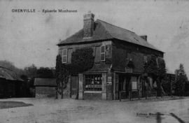
Grocery shop 
 OhervilleLocation within Upper Normandy region
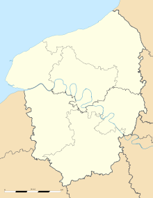 Oherville
Administration Country France Region Upper Normandy Department Seine-Maritime Arrondissement Le Havre Canton Ourville-en-Caux Intercommunality Côte d'Albâtre Mayor Hervé Jolly Statistics Elevation 42–142 m (138–466 ft)
(avg. 50 m/160 ft)Land area1 4.57 km2 (1.76 sq mi) Population2 178 (2006) - Density 39 /km2 (100 /sq mi) INSEE/Postal code 76483/ 76560 1 French Land Register data, which excludes lakes, ponds, glaciers > 1 km² (0.386 sq mi or 247 acres) and river estuaries. 2 Population without double counting: residents of multiple communes (e.g., students and military personnel) only counted once. Coordinates: 49°43′18″N 0°40′45″E / 49.7216666667°N 0.679166666667°E
Oherville is a commune in the Seine-Maritime department in the Haute-Normandie region in northern France.
Contents
Geography
A very small farming village in the Pays de Caux, situated some 30 miles (48 km) northeast of Le Havre, at the junction of the D131 and D105 roads and in the wooded valley of the river Durdent.
History
The origin of the name is from the Germanic man's name ‘’Odardus’’ and from the Latin ‘’villa’’.
The commune is made up of the union of two hamlets, Oherville, first mentioned in 1240 and Auffray, mentioned in 1040.
The existence of a feudal motte indicates the presence of a medieval castle on the site. The first seigneurs of the place are mentioned in 1170. In the Middle Ages it was a dependancy of the Duchy of Longueville. Oherville was a fiefdom under the lordship of Veauville until the 16th century.
The village’s position by the banks of the Durdent river led the construction of a number of mills. These were used for various processes, from grinding corn to the pressing of oil and the production of linen from flax. Traces of some of these mills can still be found.Heraldry
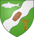
The arms of Oherville are blazoned :
Vert, on a bend sinister wavy argent between a trout argent and a garb (of wheat) Or, a mill wheel bendwise sinister in trian aspect proper.Population
Population history 1962 1968 1975 1982 1990 1999 2006 167 186 168 170 164 160 178 Starting in 1962: Population without duplicates Places of interest
- The church of Notre-Dame, dating from the sixteenth century.
- Auffray manorhouse and its dovecote, dating from the fifteenth century.
- Nonnettes manorhouse, dating from the sixteenth century.
- The remains of the medieval castle.
- The Moulin de Chanterive watermill.
See also
References
External links
- Oherville on the Quid website (French)
Categories:- Communes of Seine-Maritime
- Le Havre geography stubs


Wikimedia Foundation. 2010.