- Hazleton, Pennsylvania
Infobox Settlement
official_name = Hazleton, Pennsylvania
nickname = The Mountain City, The Power City
motto =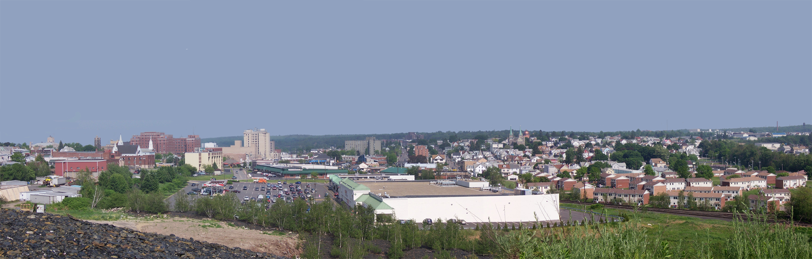
imagesize =
image_caption = Panoramic view of Hazleton overlooking Downtown and the southern section of the city.
image_
pushpin_
pushpin_label_position = left
pushpin_map_caption = Location within the state of Pennsylvania
pushpin_mapsize =
mapsize =
map_caption =
subdivision_type = Country
subdivision_type1 = State
subdivision_type2 = County
subdivision_name =United States
subdivision_name1 =Pennsylvania
subdivision_name2 = Luzerne
leader_title =Mayor
leader_name =Lou Barletta (R)
established_title = Settled
established_title1 = Incorporated (borough)
established_title2 = Incorporated (city)
established_date = 1780
established_date1 =January 5 ,1857
established_date2 =December 4 ,1891
area_magnitude =
TotalArea_sq_mi =
area_total =
LandArea_sq_mi =
area_land =
WaterArea_sq_mi =
area_water =
UrbanArea_sq_mi =
area_urban =
MetroArea_sq_mi =
area_metro =
population_as_of = 2000
population_note =
population_total = 23329
population_metro =
population_urban =
population_density =
population_density_mi2 =
timezone = EST
utc_offset = -5
timezone_DST = EDT
utc_offset_DST = -4
latd= 40 |latm= 57 |lats= 32 |latNS= N
longd=75 |longm=58 |longs=28 |longEW=W
elevation =
elevation_ft = 1689
website = http://www.hazletoncity.org/
footnotes =
area_code = 570Hazleton is a city in Luzerne County,
Pennsylvania ,United States . The population was 23,329 at the 2000 census.Greater Hazleton
The City of Hazleton and its surrounding communities are collectively known as Greater Hazleton. Greater Hazleton encompasses an area located within three counties: southern Luzerne County, northern Schuylkill County, and northern Carbon County. The population of Greater Hazleton was 80,351 [ [http://www.hazletoncando.com/population.asp Population ] ] at the 2000 census. Greater Hazleton includes the City of Hazleton; the boroughs of Beaver Meadows, Conyngham, Drifton, Freeland, Jeddo, McAdoo, Weatherly, West Hazleton, White Haven; the townships of Black Creek, Butler, East Union, Foster, Hazle, Sugarloaf; and the towns, villages, or CDPs of Audenried, Coxes Villages, Drums, Ebervale, Eckley, Fern Glen, Haddock, Harleigh, Harwood Mines, Hazle Brook, Highland, Hollywood, Hudsondale, Japan, Jeansville, Junedale, Keylares, Kis-Lyn, Lattimer Mines, Milnesville, Nuremberg, Oneida, Pardeesville, Quakake, St. Johns, Sandy Run, Stockton, Sybertsville, Ringtown, Sheppton, Tomhicken, Upper Lehigh, Weston, and Zion Grove.
History
ugarloaf Massacre
During the height of the
American Revolution in the summer of 1780, British sympathizers, known asTories , concentrated from New York'sMohawk Valley , began attacking patriot outposts located along theSusquehanna River Valley in NortheastPennsylvania . Because of the reports ofTory activity in the region, Captain Daniel Klader and aplatoon of 40 to 50 men from Northampton County were sent to investigate. They traveled north from theLehigh Valley along a path known as "Warrior's Trail," which is present-day State Route 93, since this route connects theLehigh River in Jim Thorpe (formerly known as Mauch Chunk) to theSusquehanna River in Berwick.Heading north, Captain Klader's men made it as far north as present-day Conyngham when they were ambushed by members of the
Seneca tribe andTory militiamen. In all, 18 men were killed onSeptember 11 ,1780 in what was to become the Sugarloaf Massacre.The Moravians, a
Christian denomination, had been using "Warrior's Trail" since the early 1700s after the Moravianmissionary Nicolaus Ludwig Zinzendorf first used it to reach theWyoming Valley . This particular stretch of "Warrior's Trail" had an abundance ofhazel trees. Though the Moravians called the region "St. Anthony's Wilderness," it eventually became known as "Hazel Swamp," a name which had been used previously by the Indians.The Moravian missionaries were sent from their settlements near Bethlehem to the site of the Sugarloaf Massacre to bury the dead soldiers. Because of the aesthetic natural beauty of the Conyngham Valley, some Moravians decided to stay and in 1782, built a settlement, St. Johns, along the Nescopeck Creek, which is near the present-day intersection of Interstates 80 and 81 [ [http://www.hazletonhistory.8m.com/history_origins.htm Greater Hazleton Historical Society ] ] .
Jacob Drumheller's Stage Stand
In the late 1700s and early 1800s, the "Warrior Trail" was widened and became the Berwick Turnpike. Later, a road was built to connect
Wilkes-Barre to McKeansburg. This road intersected with the Berwick Turnpike at what is present-day Broad and Vine Streets, in downtown Hazleton. Anentrepreneur named Jacob Drumheller decided that this intersection was the perfect location for a rest-stop, so in 1809, he built the first building in what would be later known as Hazleton. Though a few buildings and houses began to be built nearby, the area remained a dense wilderness for about 20 more years. Aside from small-scalelogging , the area offered little else.Discovery of coal
Railroad developers fromPhiladelphia became interested in the Hazleton area once previous rumors were validated thatanthracite coal had been discovered in near-byBeaver Meadows by prospectorsNathaniel Beach andTench Coxe .A young
engineer from New York namedAriovistus "Ario" Pardee was hired to survey thetopography of Beaver Meadows and report the practicality of extending a railroad from theLehigh River Canal in Jim Thorpe to Beaver Meadows. Pardee, knowing that the area of Beaver Meadows was already controlled by Coxe and Beach, bought many acres of the land in present-day Hazleton. The investment proved to be extraordinarily lucrative. The land contained part of a massive anthricite coal field. Pardee will be forever known as the founding father of Hazleton.Pardee incorporated the
Hazleton Coal Company in 1836, the same year that the rail link to theLehigh Valley market was about to be completed.The Hazleton Coal Company built the first school on Church Street, where Hazleton City Hall is now located. Pardee also built the first church in Hazleton located at Church and Broad Streets. The Pardee mansion was built on the northern block of Broad Street, between present-day Church and Laurel Streets.
The coal industry attracted many immigrants for labour, mostly German and Irish in the 1840s and 1850s, and mostly Italian, Polish, Russian, Lithuanian, and Slovak in the 1860s to 1920s.
The coal mined in Hazleton helped to establish the United States as a world industrial power, primarily fueling the massive
blast furnaces at the Bethlehem Steel Corporation. [ [http://www.hazletonhistory.8m.com/coal.htm Greater Hazleton Historical Society ] ]"Patch Towns"
Many small
company towns , often referred to by locals as "patch towns," surrounded Hazleton and were built by coal companies to provide housing for the miners and their families. The patch towns included:*Beaver Meadows, coal was discovered here
*Stockton, founded by John Stockton
*Jeansville, founded by James Milens
*Milnesville, founded by James Milens
*Tresckow, formerly known as Dutchtown
*Junedale, formerly known as Colraine
*Freeland, originally Birbeckville after founder Joseph Birbeck, then South Heberton
*McAdoo, originally called Pleasant Hill, then Saylors Hill
*West Hazleton, founded by Conrad Horn
*Eckley, founded by Eckley B. Coxe
*Jeddo, named after a Japanese port in which coal was exported to by the Hazleton Coal Company
*Hollywood, area now part of Hazleton, named beforeHollywood, California .
*Weatherly, small borough outside of Hazletonudden prosperity and growth
Hazleton was incorporated as a borough on
January 5 ,1857 . Its intended name was supposed to be spelled "Hazelton" but a clerk misspelled the name during incorporation, and the name "Hazleton" has been used ever since. The borough's firstfire company , the Pioneer Fire Company, was organized in 1867 by soldiers returning from theAmerican Civil War . Hazleton was incorporated as a city onDecember 4 ,1891 . The population then was estimated to be around 14,000 people.In 1891, Hazleton became the third city in the United States to establish a city-wide electric grid.
On
September 10 1897 , theLattimer Massacre occurred near Hazleton.Changing times and fuels
After World War II, the demand for coal began to decline as cleaner, more efficient fuels were being used. Readily available, cheap energy helped open the door for manufacturing. The Duplan
Silk Corporation opened and became the world's largest silk mill [ [http://www.hazletonhistory.8m.com/duplan.htm Greater Hazleton Historical Society ] ] . The garment industry thrived, some operations serving as a front for mafia bossAlbert Anastasia .In 1947,
Autolite Corporation was looking to expand operations in the East, and had been looking into Hazleton. Officials from Autolite came to the area to survey it and in their report, they noted Hazleton is a "mountain wilderness" with no major water route, rail route, trucking route, or airport. In response, several area leaders gathered to address these problems.CANDO (Community Area New Development Organization) was formally organized in 1956 by founderDr. Edgar L. Dessen . Their main goal was to raise money, through their "Dime A Week" campaign, in which area residents were encouraged to put a dime on their sidewalk each week to be collected by CANDO. The company raised over $250,000 and were able to purchase over convert|500|acre|km2 of land, which was converted into an industrial park. Because of CANDO's efforts, Hazleton was given theAll-America City Award . Hazleton's economy is now based largely on manufacturing and shipping, facilitated by the relative closeness to Interstates 80 and 81.An article published in December 2002 by
US News and World Report was entitled "Letter from Pennsylvania: A town in need of a tomorrow" which reported Hazleton's shortcomings to the world. It was criticized by local politicians and business leaders alike, and again prompted local leaders to address the problems facing the community.River dredge question
Many local leaders looked for solutions to help change the appearance and perceptions of Hazleton. Similar attempts had been made in the 1980s to try and help clean up and revitalize the image of Downtown Hazleton. Since the local economy had declined, the big department stores closed their doors and left behind a bleak and dreary downtown. Many old buildings had been saved by recent restoration efforts, but the empty storefronts remain.
In 2005, Mayor
Louis Barletta and a private firm introduced a controversial plan to import millions of tons of sediment dredged from the New Jersey and New York harbors and surrounding rivers. The plan calls for the river dredge to be used as fill for the many mine craters left behind from abandoned strip-mining operations. After the mines are filled and the land restored, the plan calls for a 20,000-seat open-air amphitheater. It was the hope of the mayor and the developers that the amphitheater would give people a reason to visit Hazleton and that the project would stimulate the local economy. The plan drew many opponents because of the already-high cancer rate in the region. Many felt capping the mines was an unnecessary risk, because many had questions about pollutants that may be found in the dredge.Cargo airport
Perhaps the most substantial attempt to bring Hazleton's economy back has been a proposed cargo airport to be built convert|2|mi|km south of Hazleton near the Humboldt Industrial Park and Eagle Rock Resort. The planners of the project are expecting $17 billion to be injected into the local economy, as well as 4,500 direct airport jobs, and as many 160,000 indirect jobs. The planners are hoping the airport will replace the coal industry, but because of the many attempts to recover in the past, many admit the project seems more of a flight of fancy. But recently it has been gaining more approval from local politicians and has a possibility of becoming a reality. Some residents are opposed, citing noise, population, and traffic concerns. Others are fairly optimistic, citing the potential for widespread economic, educational, and cultural growth.
Geography
Hazleton is located at coor dms|40|57|32|N|75|58|28|W|city (40.958834, -75.974546).GR|1
According to the
United States Census Bureau , the city has a total area of 6.0 square miles (15.5 km²), all of it land.Hazleton is located 12 miles (19 km) north of Tamaqua and 25 miles (40 km) south of Wilkes-Barre. Located on a plateau of Spring Mountain, Hazleton's elevation is about 1700 feet (518 m) above sea level, one of the highest incorporated cities east of the
Mississippi River and the highest in Pennsylvania. It straddles the divide between the Delaware and Susquehanna watersheds.Demographics
As of the
census GR|2 of 2000, there were 23,329 people, 10,281 households, and 6,004 families residing in the city. Thepopulation density was 3,904.6 people per square mile (1,508.8/km²). There were 11,556 housing units at an average density of 1,934.1/sq mi (747.4/km²). The racial makeup of the city was 94.70% White, 0.82% African American, 0.16% Native American, 0.65% Asian, 0.01% Pacific Islander, 2.76% from other races, and 0.89% from two or more races. Hispanic or Latino of any race were 4.85% of the population (however, some estimates show that this has grown to as high as 30% since the 2000 Census [ [http://www.newsday.com/news/nationworld/nation/ny-usimmi254795533jun25,0,193310.story?coll=ny-nationalnews-print Newsday article] Dead link|date=March 2008] ).There were 10,281 households out of which 24.0% had children under the age of 18 living with them, 40.1% were married couples living together, 13.6% had a female householder with no husband present, and 41.6% were non-families. 37.0% of all households were made up of individuals and 19.4% had someone living alone who was 65 years of age or older. The average household size was 2.23 and the average family size was 2.93.
In the city the population was spread out with 21.0% under the age of 18, 7.8% from 18 to 24, 26.7% from 25 to 44, 22.2% from 45 to 64, and 22.2% who were 65 years of age or older. The median age was 41 years. For every 100 females there were 87.7 males. For every 100 females age 18 and over, there were 82.7 males.
The median income for a household in the city was $28,082, and the median income for a family was $37,093. Males had a median income of $31,144 versus $20,926 for females. The
per capita income for the city was $17,270. About 10.4% of families and 14.2% of the population were below thepoverty line , including 20.4% of those under age 18 and 11.6% of those age 65 or over.Economy
All of Hazleton's major mining and garment industries have disappeared over the past 50 years. Through the efforts of CANDO and a practical highway infrastructure, Hazleton has become home to many industrial parks.
The Hershey Company ,Office Max ,Simmons Bedding Company ,Michaels ,Network Solutions ,AutoZone , andGeneral Mills are just some of the large companies with distribution, manfacturing, or logistic operations in Hazleton. It was recently announced thatAmazon will be opening a fulfillment center in Hazleton, which will create more than 1,000 new jobs in the area. [http://www.reuters.com/article/pressRelease/idUS205979+19-May-2008+BW20080519]Notable natives and residents
*
Hubie Brown , former basketball coach and a current television analyst
*Amber Lee Ettinger , model and actress
*Sarah Knauss , lived to age 119
*Jan Lewan , was the "Polka King" and had a wealth management business. He was eventually jailed for embezzlement and was attacked while incarcerated.
*Joe Maddon , manager of Major League Baseball's Tampa Bay Rays
*S.A. McLaughlin , poet
*Judith Nathan , wife of former New York City Mayor Rudolph Giuliani
*Jack Palance , Oscar-winning actor
*John "Dandy Jack" Parisi , long-time associate ofAlbert Anastasia , the reputed head ofMurder, Inc. , in New York
*Eric Sugarman , Head Athletic Trainer, Minnesota Vikings of the NFL
*Timothy Tray , Hazleton Documentarian
*Bob Tucker, NFL Tight End with the Minnesota Vikings
*Neal Wood, Jr. , Freeland native, inventor of the Sonic Nap Alert Pattern (SNAP) rumble strips on road shoulders
*Jen Yemola , participant in Season 3 of Hell's KitchenHazleton in popular culture
*In 1968, the major motion picture "The Molly Maguires" was filmed in
Eckley, Pennsylvania , about convert|3|mi|km from Hazleton. Portions of the film were also shot inJim Thorpe, Pennsylvania .*In 1997, the Pennsylvania rock band Fuel released an EP titled "Hazleton." The EP was so named because it was recorded at C and C Recording Works in Hazleton.
*Parts of
Gypsy 83 (2001), were shot in and around Hazleton. In an assumed nod to the area, a character in the movie was named "Hazleton".Local media
Newspapers
*Standard-Speaker, daily newspaper (name merged from Daily Standard and Plain Speaker)
*El Mensajero, Spanish newspaperRadio
*Radio
WAZL (AM) , on the air since 1932.Television
*Local News 13 (Local cable subscribers only)
*WYLN-35 Broadcast Channel 35 and Service Electric Cablevision cable channel 7Education
History of local education
*The first school was built in the 1830s by the Hazleton Coal Company. It was a private elementary school at the corner of Church and Green Streets, the present-day site of Hazleton City Hall.
*Hazleton High School, the first high school, was built in 1875 at Pine and Hemlock Streets, the present-day site of the Pine Street Playground.
*Hazleton Senior High School, the Mountaineers, was built at 9th and Wyoming Streets, in 1926.
*Hazle Township High School, the Shippers
*Foster Township High School, the Falcons
*McAdoo High School, the Maroons
*Freeland High School, the Whippets
*Black Creek Township High School, the Rockets
*West Hazleton High School, the Wildcats
*Immanuel Christian School, the Lions
*Heights Terrace El/Middle School, the HawksHazleton Area School District
Between 1966 and 1992, the
Hazleton Area School District closed all area high schools except Hazleton, Freeland, and West Hazleton. The Hazleton Area High School opened in 1992, which resulted in the complete consolidation of all remaining area high schools.The Hazleton Area School District encompasses convert|300|sqmi|km2, which is one of the largest school districts in the state. It includes 1 city, 6 boroughs, 9 townships, (16 municipalities) and 3 counties. Enrollment is currently over 10,000 students. In 2004, the Hazleton Area High School was the 11th largest high school in the state.
The schools of the Hazleton Area School District are:
*Arthur Street Elementary School
*Drums Elementary School
*Freeland Elementary Middle School
*Hazleton Elementary Middle School
*Heights-Terrace Elementary Middle School
*McAdoo/Kelayres Elementary School
*Valley Elementary/Middle School
*West Hazleton Elementary/Middle School
*Hazleton Area High School
*Hazleton Area Career CenterCurrent Hazleton Area School Board Directors are:
*Elaine Curry, president
*Jack Shema
*Sean Shamany
*Dr. Robert Childs
*Carmella Yenkevich
*Steve Hahn
*Tony Bonomo
*Paulette Platukis
*Brian EarleyPrivate schools
*
MMI Preparatory School
*Bishop Hafey High School (closed 2007)
*Holy Family Academy
*Immanuel Christian SchoolColleges and universities
*
Penn State Hazleton
*Lackawanna College
*Luzerne County Community College
*McCann School of Business and Technology Government
Mayor
*
Louis J. Barletta City Council
*Joseph Yannuzzi, President
*Jack Mundie, Vice President
*Evelyn Graham
*Tom Gabos
*Robert NillesTransportation Infrastructure
Air Transit
Hazleton's commercial passenger airport is the
Wilkes-Barre/Scranton International Airport located inAvoca, Pennsylvania . TheLehigh Valley International Airport also serves Greater Hazleton. TheHazleton Municipal Airport is the general aviation airport for the city.Public Transportation
Public transportation is provided by the Hazleton Public Transit, a service of the City of Hazleton's Department of Public Services. HPT operates nine routes throughout the city and neighboring communities.
Rail
While Hazleton currently has no passenger rail service, it is a major regional center for commercial rail traffic, operated by
Norfolk Southern Railway .Roads
Three interstate highways run through the Hazleton area, with associated exits to the city.
*Interstate 81 , which runs fromDandridge, Tennessee in the south, toWellesley Island , NY in the north.
*Interstate 80, which runs fromSan Francisco, California in the west, toHackensack, New Jersey in the east.
*Interstate 476 , the Northeast Extension of thePennsylvania Turnpike , which runs from Philadelphia to Scranton.There are five major inbound roads to Hazleton: Church Street, Broad Street, CANDO Expressway, Greater Hazleton Chamber Of Commerce Beltway and 22nd Street.
Museums and cultural organizations
*
Eckley Miners' Village
*The Greater Hazleton Historical Society
*The Hazleton Area Public LibraryParks and Recreation
Annual Festivals
Hazleton's annual street festival, Funfest, is celebrated usually during the second weekend of September. The festival includes a craft show, a car show, entertainment from local bands, and many games of chance. The Funfest parade is held on Sunday during the Funfest weekend. First Night Hazleton's annual New Years Party. Valley Day is celebrated in Conyngham during the summer.
Parks
*Community Park, Hazle Township
*Altmiller Playground
*Greater Hazleton Rails To Trails
*Lehigh Gorge State Park
*Hickory Run State Park
*Paragon Off-Road Adventure Park
*Whitewater Challenge, in Jim Thorpe
* [http://www.eaglerockresort.com/ Eagle Rock Resort]
*Edgewood In The Pines Golf Course
*Valley Country Club Golf CourseLandmarks and Historic Locations
*
Eckley Miners' Village , Eckley, PA
*Saint Gabriel The Archangel Roman Catholic Church, 122 South Wyoming Street
*Saint Joseph Slovak Roman Catholic Church, 601 North Laurel Street, the first Slovak Roman Catholic church established in the Western Hemisphere
*Our Lady of Mount Carmel Tyrolean Roman Catholic Church, the only Tyrolean church in the United States
*Hazleton Elementary Middle School (formerly Hazleton Senior High School)
*The Markle Building, tallest building in Luzerne county
*The Traders Bank Building
*The Altamont Hotel
*The Hazleton National Bank
*The Duplan Silk Building
*The march of theLattimer Massacre , which began at State Route 924 near Harwood
*The site of theLattimer Massacre in Hazle Township
*The Hazleton Cemetery (the Vine Street Cemetery)
*Saint Mary's Byzantine Catholic Church, Freeland, PA, the mother parish of Byzantine-Ruthenian Catholic Churches in the United StatesSister cities
Hazleton has several sister cities. They are:
* -Gorzow Wielkopolski ,Lubuskie ,Poland
* - Mountain Communities of Lambro and Mingardo,Campania ,Italy
* - see link for name places in the USA [http://mysite.verizon.net/vze8isfi/hazleton.html]anctions against illegal immigrants
In 2006, Hazleton gained national attention as Republican mayor
Lou Barletta and council members passed theIllegal Immigration Relief Act . [ [http://www.smalltowndefenders.com/public/node/6 Text of the ordinances] ] This ordinance was instituted to discourage hiring or renting to illegal immigrants. Initially, an administrative fine on landlords for $1000 per illegal immigrant rented to and a loss of permits for non-compliance has been passed. [ [http://www.smalltowndefenders.com/public/node/6 Illegal Immigration Relief Act passed | Small Town Defenders - Hazleton, Pennsylvania ] ] Leaders from other communities across the United States have requested information on this proposal for use in their own municipalities. [ [http://www.hazletoncity.org/2006_10_Illegal_Immigration_Relief_Act_%20NEW.pdf Home - Official Web Site of the City of Hazleton, Pennsylvania ] ] [ [http://www.phillyjwj.org/ordinance.html Philadelphia Jobs with Justice] Dead link|date=April 2008] Another act passed concurrently made English theofficial language of Hazleton. [ [http://www.smalltowndefenders.com/090806/2006-19%20_Official%20English.pdf 2006-19 _Official English ] ]The ordinance has been criticized as illegal and
unconstitutional . A number ofHispanic residents (both legal and illegal) filed suit to strike down the law, claiming it violates theSupremacy Clause of theU.S. Constitution as well as the First and Fourteenth Amendments to the Constitution. A copy of the court complaint is available from the Pennsylvania ACLU. [ [http://www.aclupa.org/legal/legaldocket/challengetohazletonimmigra.htm Lozano v. City of Hazleton :: American Civil Liberties Union of Pennsylvania ] ] In an agreement, announced onSeptember 1 , with the ACLU, thePuerto Rican Legal Defense and Education Fund and theCommunity Justice Project , Hazleton will not enforce the ordinance for now. [ [http://www.aclu.org/immigrants/discrim/26644prs20060901.html American Civil Liberties Union : Coalition Gains Immediate Halt to Unconstitutional Ordinance in Hazleton, PA ] ] In response to the lawsuits the city of Hazleton has retained the counsel of the former head of immigration in the Department of Justice. [ [http://www.canyon-news.com/artman/publish/article_4809.php Canyon News - The Hazleton Case: The People vs. the ACLU ] ]Mayor Lou Barletta of Hazleton estimates that as "many as half" of the estimated 10,000 Hispanics who were living in Hazleton left Hazleton when the ordinance was passed. [http://www.washingtontimes.com/national/20060921-110748-4227r.htm Washington Times article] Dead link|date=April 2008] Reportedly, several shops in the city's Hispanic business district have closed, with others struggling to remain open. [http://www.suntimes.com/news/nation/118825,CST-NWS-illegal01.article Chicago Sun Times article] Dead link|date=April 2008] The issue was covered by the television program "
60 Minutes " in 2006 [ [http://www.cbsnews.com/stories/2006/11/17/60minutes/main2195789.shtml Welcome To Hazleton, One Mayor's Controversial Plan To Deal With Illegal Immigration - CBS News ] ] and the "Fox News " show The "O'Reilly Factor " in March 2007. [ [http://www.billoreilly.com/show?action=viewTVShow&showID=1245#2 BillOReilly.com: The O'Reilly Factor Flash ] ]The local Chamber of Commerce claims that the influx of both legal and illegal immigrants revitalized a dying coal town, turning a dismal commercial strip on Hazleton's Wyoming Street into a lively row of shops. The
U.S. Chamber of Commerce filed an amicus brief in support of the ACLU's case. [ [http://www.forbes.com/businessinthebeltway/2007/07/18/immigration-arizona-congress-biz-beltway-cz_jn_0719beltway.html Immigration Shootout At The Local Corral - Forbes.com ] ] The mayor said that murders and other violent crimes had increased dramatically over the prior 10 years. [ [http://transcripts.cnn.com/TRANSCRIPTS/ldt.html CNN.com - Transcripts ] ] . However, evidence presented in court showed Hazleton's crime rate actually declined at the same time its Hispanic population was increasing [ [http://www.newsnet14.com/2007/03/21/hazleton-police-chief-testifies-illegals-bring-more-crime/ Hazleton Police Chief testifies: illegals bring more crime] . March 21, 2007.] .On
July 26 ,2007 a federal judge, James Munley, struck down Hazleton's Illegal Immigration Relief Act as an unconstitutional ordinance pre-empted by federal law. [ [http://www.nytimes.com/2007/07/27/us/27hazelton.html Judge Voids ordinance on Illegal Immigration. The New York Times. July 27, 2007] ] The injunction stirred up a national controversy. Mayor Barletta expressed his confidence that the injunction will be overturned by the appellate court.References
External links
* [http://www.hazletoncity.org/home_frameset.htm City of Hazleton Pennsylvania Home Page]
* [http://www.hazletoncando.com/index.asp CANDO Home Page]
* [http://hazletonarea.net Hazleton Directory]
* [http://www.aclupa.org/legal/legaldocket/challengetohazletonimmigra.htm ACLU of Pennsylvania Immigration Challenge]
* [http://www.mcadoo.info/ My McAdoo Homepage] - Anti-dredge opinion site
* [http://mysite.verizon.net/vze8isfi/hazleton.html U.S. towns named Hazelton]
* [http://www.sira4x4.net/saveparagon/ SaveParagonAP.com - Keep Paragon Adventure Park open]
*

Wikimedia Foundation. 2010.