- North Truro Air Force Station
-
North Truro Air Force Station 
Part of Air Defense Command (ADC) North Truro, Massachusetts 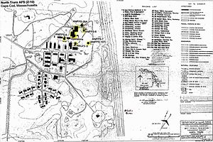
A map of the stationType Long Range Radar Site Coordinates 42°01′53.38″N 70°03′11.84″W / 42.0314944°N 70.0532889°W Location code ADC ID: P-10 NORAD ID: Z-10 (NTAFS) Built 1951 Built by United States Air Force In use 1951-1994 Current
ownerNational Park Service Open to
the publicPartially Controlled by  United States Air Force
Garrison North Truro, Massachusetts Occupants 762d Radar Squadron, 6th Space Warning Squadron 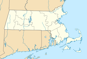
 North Truro AFSLocation of North Truro AFS, Massachusetts
North Truro Air Force Station is a closed United States Air Force General Surveillance Radar station. It is located 2.2 mi (3.5 km) east of North Truro, Massachusetts.
Most of the site was inactivated in 1994 and turned over to the National Park Service, the radar site remainder becoming an Federal Aviation Administration (FAA) VHF Omnidirectional Range/Tactical Aircraft Control (VORTAC) radar site, part of the Joint Surveillance System (JSS), designated by NORAD as Northeast Air Defense Sector (NEADS) Ground Equipment Facility J-53.
Contents
Overview
The former North Truro AFS is the site of a radar station and several abandoned buildings including barracks, a library, a bar, a bowling alley and a family housing area located to the south. NTAFS has been redeveloped into The Highland Center.[1] It is also the site of the Jenny Lind Tower.[2]
History
North Truro was one of the first of twenty-four stations of the permanent Air Defense Command radar network. On December 2, 1948, the Air Force directed the Army Corps of Engineers to proceed with construction of this and twenty-three other sites around the periphery of the United States.
The 762d Aircraft Control and Warning Squadron began operations with a pair of World War II Air Transportable Search and Detection AN/CPS-3 radars at North Truro in 1951 and assumed radar coverage previously covered by a temporary Lashup radar site at Otis AFB (L-5), and initially the station functioned as a Ground-Control Intercept (GCI) and warning station. As a GCI station, the squadron's role was to guide interceptor aircraft toward unidentified intruders picked up on the unit's radar scopes. In 1955 these units were joined by an AN/FPS-8 model. Eventually converted to an AN/GPS-3, this radar left service in 1960. In 1956 a GE CPS-6B search radar was the main search radar.[citation needed]
NTAFS was the operational parent station for Texas Tower 2 (TT-2) offshore in the Atlantic Ocean from May 1956-15 January 1963. TT-2 was operated as an annex (of the 762d AC&W Squadron, its offshore personnel assigned to a flight of the 762d, although the facility was logically supported by the 4604th Support Squadron (Texas Towers) at Otis AFB.
The years 1958 and 1959 saw the arrival of AN/FPS-6 and 6A height-finder radars. During 1958 North Truro AFS joined the Semi Automatic Ground Environment (SAGE) system, feeding data to DC-02 at Stewart AFB, New York. After joining, the squadron was re-designated as the 762d Radar Squadron (SAGE) on 15 December 1958. The radar squadron provided information 24/7 the SAGE Direction Center where it was analyzed to determine range, direction altitude speed and whether or not aircraft were friendly or hostile.
In 1960 the 762d started operating an AN/FPS-7 radar. In 1963 the height-finder radars were replaced by AN/FPS-26A and AN/FPS-90 sets. Redesignated the 762nd Air Defense Group (1969). Utilized Buic III equipment (Burroughs D828 Computer system) for command and control of air defense aircraft in the event that the Sage Direction Center at Hancock Field, New York, was inoperable. The unit commander and in times of Level IV operations, overall air defense commander for the NORAD region, was Col. Alva D. Henehan (1969-71?).
In addition to the main facility, NTAFS operated three unmanned AN/FPS-14 Gap Filler sites:
- Westboro, MA (P-10A) 42°14′23″N 071°37′41″W / 42.23972°N 71.62806°W
- Fort Dearborn, NH (P-10B) 43°02′49″N 070°42′58″W / 43.04694°N 70.71611°W
- Chilmark, MA (P-10E) 41°21′19″N 070°44′07″W / 41.35528°N 70.73528°W
Fort Dearborn was the former Rye AFS, which had closed in 1957. Westboro closed in June 1962, the others in June 1968.
Over the years, the equipment at the station was upgraded or modified to improve the efficiency and accuracy of the information gathered by the radars. Routine operations continued and in 1979 the site came under Tactical Air Command jurisdiction as a result of the inactivation of Aerospace Defense Command and the site became part of ADTAC. By 1985 AN/FPS-107 had been replaced by an AN/FPS-91A search set operated by the FAA. The AN/FPS-116 was removed circa 1988
Operation Have Horn
In 1969 North Truro Air Force Station was the location of Operation Have Horn, the launching of sounding rockets under project Nike Hydac. On completion of the operation in 1970, the used devices and equipment were returned to the White Sands Missile Range.[3]
Closure
At the end of the Cold War in 1994, the Air Force closed down operations at North Truro and it was sold to the National Park Service. In the late 1990s, an ARSR-4 replaced the AN/FPS-91A. when it joined the Joint Surveillance System (JSS).
Several of the facilities have fallen into disrepair while some are in the process of renovation. The Gap Filler at Westboro is intact and has what appears to be a water tower and several radio broadcasting towers. The other two Gap Filler sites have been obliterated and redeveloped. The former Texas Tower No. 2 (TT-2) troposcatter communications site, just south of the housing area, is also accessible on foot. All that remain of the tropo facility are the building foundation (a concrete pad with a few floor tiles) and three-each concrete footings for the three tropo dish antennas. At the main site, the fence around the former cantonment and technical areas has a gate on the ocean-facing side. All of the original USAF radar towers are gone. The only radar tower now is the ARSR-4. The buildings are each in various conditions, however all are in derelict condition with the exception of the few buildings that are being repaired. The homes in the family housing area are falling apart and some have been vandalized. A few buildings had been torn down, including the station chapel. The former GATR site located approximately 1.2 miles southeast of the base at Longnook Beach has been demolished, and all of the radio poles have been removed. The site is now home to an FAA NAVAID station.
Redevelopment
NTAFS itself was given to the Cape Cod National Seashore and is now being redeveloped into the Highlands Center. This project includes the building of a performing arts center, and other facilities to meet the needs of the National Park Service as well as the community. It is also home to an FAA long-range radar site. In October 2008, a bus driver was indirectly struck by lightning while closing a gate at the center.
Units and assignments
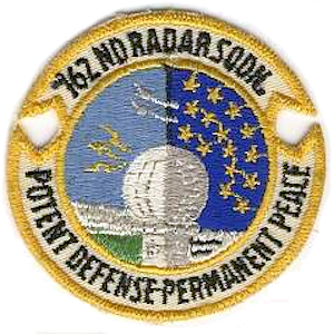
 Emblem of the 762d Radar Squadron
Units:
- 762d Aircraft Control & Warning Squadron, 1 January 1951
-
- Unit was activated at Otis AFB (L-5), Massachusetts, 27 November 1950
- Redesignated: 762d Radar Squadron (SAGE), 15 December 1958
- Elevated to: 762d Air Defense Group, 1 March 1970
- Reduced to: 762d Radar Squadron on 1 January 1974
- Inactivated on 15 January 1984
- 6th Space Warning Squadron (Detachment 1) (1977–1985)
Assignments:
- 540th Aircraft Control and Warning Group, (32d Air Division), 1 January 1951
- 32d Air Division, 6 February 1952
- 4704th Defense Wing, 16 February 1953
- 4622d Air Defense Wing, 18 October 1956
- Boston Air Defense Sector, 8 January 1957
- 35th Air Division, 1 April 1966
- 21st Air Division, 19 November 1969
- 21st ADCOM Region, 8 December 1978
- Re-designated: 21st NORAD Region, 1 October 1979-15 January 1984
Gallery
-

Barracks
-

Radar facility to the north of the station
-

175th CEF markings
-

Abandoned playground
-

Family housing
-

Power plant
-

Map
See also
- Rocket launch sites
- List of USAF Aerospace Defense Command General Surveillance Radar Stations
References
 This article incorporates public domain material from websites or documents of the Air Force Historical Research Agency.
- Winkler, David F. (1997), Searching the skies: the legacy of the United States Cold War defense radar program. Prepared for United States Air Force Headquarters Air Combat Command.
- A Handbook of Aerospace Defense Organization 1946 - 1980, by Lloyd H. Cornett and Mildred W. Johnson, Office of History, Aerospace Defense Center, Peterson Air Force Base, Colorado
- Information for North Truro AFS, MA
- USAFHRA History search, 762 Radar Squadron
External links
- http://www.hcitruro.org
- The MITRE site in South Truro
- http://www.astronautix.com/sites/nortruro.htm
- http://www.aliciapatterson.org/APF0103/Brodeur/Brodeur.html
- http://www.nps.gov/archive/caco/news/GeneralHighlands.html
- http://www.flra.gov/decisions/v03/03-017-3.html
- http://www.koreanwar.org/html/units/bases/usaf_ke.htm?set=250
- http://www.radomes.org/museum/savethe35.html
- http://books.google.com/books?id=tXnKhejsTskC&pg=PA10&lpg=PA10&dq=north+truro+air+force+station&source=web&ots=NgehgXgyqd&sig=dW-wc9gV1IUzu4LavV-Fy-0SqYc#PPA11,M1
- http://www.flight800.org/petition/pet_sect4.htm
- YouTube video of people driving around the old housing area
- [http://www.youtube.com/watch?v=Vgo_2iXgQ4I A YouTube video inside of one of the houses at the base.
Military installations of MassachusettsActive CampsCamp Edwards · Camp Curtis GuildCentersGeorge H. Crosman United States Army Reserve Center · United States Army Natick Soldier Research, Development and Engineering Center · United States Army Soldier Systems CenterFortsHeliportsCamp Edwards HeliportReservationsCentersMarine Corps Reserve Center, Fort Devens · Westover Armed Forces Reserve CenterBasesBarnes ANGB · Hanscom AFB · Otis ANGB · Westover JARBCentersLaboratoriesAir Force Cambridge Research LaboratoryStationsCentersUnited States Coast Guard Support CenterDepotsUnited States Coast Guard Buoy Depot, South WeymouthStationsBoston · Brant Point · Cape Cod Canal · Chatham · Gloucester · Menemsha · Merrimack River · Point Allerton · Provincetown · Scituate · Woods Hole
Inactive AirfieldsArmoriesArsenalsCampsAdams · Andrew · Banks · Bartlett · Brigham · Cameron · Candoit · Dalton · Edmunds · Ellsworth · Gardner · Guild · Havedoneit · Hill · Hingham · Hooker · Houston · Lander · Lincoln · Meigs · Myles Standish · Perkins · Prescott · Prospect Hill · Schuyler · Scott · Sheppard · Sutton · Washburn · Wellfleet · Wightman · WoolCentersCrosman · Gardner · Greenfield · Hingham · Maloney · MillisFiring RangesPopponesset · Scorton NeckFortsAcushnet · Andrews · Banks · Beverly · Bonnet Point · Cow · Dawes · Defiance · Duvall · Eastern Point · Gilbert Heights · Gloucester · Glover · Heath · Independence · Juniper · Lee · Massachusetts · Miller · Nichols · Old Stone · Phillip · Phoenix · Pickering · Ralph · Revere · Rodman · Ruckman · Sewall · Stage · Standish (1st) · Standish (2nd) · Stark · Strong · Warren · Washington · WinthropHeliportsGeorge H. Crosman United States Army Reserve Center HeliportHospitalsLovell · Murphy · WilliamsLabsArmy Materials Technology LaboratoryNike SitesB-03C · B-03L · B-05C · B-05L · B-15C · B-15L · B-17C · B-17H · B-17L · B-18 · B-21DC · B-21HA · B-36C · B-36L · B-37C · B-37L · B-38C · B-38L · B-40H · B-55C · B-55L · B-63C · B-63L · B-73L · B-84L · B-85C · B-85L · PR-19C · PR-19H · PR-19L · PR-29A · PR-29C · PR-29LPlantsLowell Ordnance PlantReservationsBarneys Joy Point · Brewster Islands · Calf Island · East Point · Elizabeth Islands · Fourth Cliff · Grover's Cliff · Long Island · Mishaum Point · Sagamore Hill · Salisbury BeachTrainingAir StationsAirfieldsAmmunition DepotsHingham (Hingham Annex)AreasGull Island Bomb · Tisbury Target · Weepecket Island BombAuxiliary Air FacilitiesAyer · Beverly · Hyannis · Martha’s Vineyard · Nantucket · New Bedford · OtisFacilitiesProvincetown Mine Test · Tom NeversHospitalsPlantsBedford Naval Weapons Industrial Reserve PlantReserve CentersChicopee · Navy & Marines, Lawrence · QuincyRangesTest StationsUnited States Navy Field Test Station, Fort HeathYardsBoston Navy Yard (South Boston Annex) (East Boston Annex)BasesOtis · WestoverFacilitiesPost Attack Command and Control System Facility, HadleyHospitalsPlants28 · 29 · 63 · 69SitesAcushnet Communications Site GWEN 404RangesQuabbin Reservoir Precision Bombing and Gunnery RangeStationsNorth Truro · Stony BrookTexas Towers2 3LoranCape Cod · Martha's Vineyard · NantucketStationsBases CONUSAdair · Beale · Bong (unbuilt) · Charleston · Davis-Monthan · Dobbins · Dover · Dow · Duluth · England · Ent · Ethan Allen · Fairfax · Fort Lee · Geiger · George · Glasgow · Grand Forks · Grenier · Griffiss · Gunter · Hamilton · Hancock · Homestead · Hurlburt · Imeson · K.I. Sawyer · Kincheloe · Kingsley · Kirtland · Larson · Luke · March · Malmstrom · McCoy · McChord · McClellan · McGhee Tyson · McGuire · Minneapolis-St. Paul · Minot · Mitchel · New Castle · Niagara Falls · Norton · O'Hare · Oklahoma City · Otis · Oxnard · Paine · Perrin · Peterson · Pittsburgh · Pope · Portland · Presque Isle · Richards-Gebaur · Selfridge · Seymour Johnson · Sioux City · Snelling · Stead · Stewart · Suffolk County · Tinker · Travis · Truax · Tyndall · Vandenburg · Webb · Westover · Willow Run · Wright-Patterson · Wurtsmith · Youngstown
OverseasErnest Harmon · Frobisher Bay · Goose Bay · Keflavik · Pepperrell · Thule · Topsham

Stations CONUSAlmaden · Charleston · Clear · Cross City · Benton · Empire · Mill Valley · Montauk · Mount Hebo · North Truro · Point Arena · Rye · Thomasville · Watertown
OverseasAlbrook
Air
Defense
unitsForcesAir
DivisionsSectorsAlbuquerque · Bangor · Boston · Chicago · Detroit · Duluth · Goose · Grand Forks · Great Falls · Iceland · Kansas City · Los Angeles · Minot · Montgomery · New York · Oklahoma City · Phoenix · Portland · Reno · Sault Sainte Marie · San Francisco · Seattle · Sioux City · Spokane · Stewart · Syracuse · Washington
WingsGroups1st · 4th · 10th · 14th · 15th · 23rd · 32nd · 33rd · 50th · 52nd · 53rd · 54th · 56th · 57th · 73rd · 78th · 79th · 81st · 82nd · 84th · 325th · 326th · 327th · 328th · 329th · 337th · 355th · 408th · 412th · 414th · 473rd · 475th · 476th · 478th · 500th · 501st · 502d · 503d · 507th · 514th · 515th · 516th · 517th · 518th · 519th · 520th · 521st · 525th · 527th · 528th · 529th · 530th · 533d · 534th · 564th · 566th · 567th · 568th · 575th · 678th · 701st · 4676th · 4700th · 4721st · 4722d · 4727th · 4728th · 4729th · 4730th · 4731st · 4732d · 4733d · 4734th · 4735th · 4756th
SquadronsAerospace Defense Command Fighter Squadrons · Aircraft Control and Warning Squadrons
Major
weapon
systemsElectronicFightersMissiles1 · 2 · 3 · 4 · 5
ShipsGuardian · Interceptor · Interdictor · Interpreter · Investigator · Locator · Lookout · Outpost · Pickett · Protector · Scanner · Searcher · Skywatcher · Tracer · Watchman · Vigil
Miscellaneous Air Defense Command Emblem Gallery (On Wikimedia Commons) · General Surveillance Radar StationsCategories:- SAGE sites
- Radar stations of the United States Air Force
- Aerospace Defense Command
- Military facilities in Massachusetts
- Closed facilities of the United States Air Force
- Buildings and structures in Barnstable County, Massachusetts
- Cape Cod National Seashore


Wikimedia Foundation. 2010.