- Montoursville, Pennsylvania
-
Montoursville, Pennsylvania — Borough — Broad Street in Montoursville Map of Lycoming County, Pennsylvania highlighting Montoursville
 Map of Pennsylvania highlighting Lycoming County
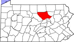
Coordinates: 41°15′10″N 76°54′56″W / 41.25278°N 76.91556°WCoordinates: 41°15′10″N 76°54′56″W / 41.25278°N 76.91556°W Country United States State Pennsylvania County Lycoming Settled 1820 Incorporated (borough) 1850 Government – Mayor John Dorin Area – Total 4.2 sq mi (10.8 km2) – Land 4.0 sq mi (10.5 km2) – Water 0.2 sq mi (0.3 km2) 3.12%% Elevation 535 ft (164 m) Population (2000) – Total 4,777 – Density 1,181/sq mi (456.5/km2) Time zone Eastern Time Zone (North America) (UTC-5) – Summer (DST) EDT (UTC-4) ZIP code 17754 Area code(s) 570 FIPS code 42-50720[1] GNIS feature ID 1213650[2] Website Montoursville Borough Montoursville is a borough in Lycoming County, Pennsylvania, in the United States. As of the 2000 census, the borough population was 4,777. It is part of the Williamsport, Pennsylvania Metropolitan Statistical Area. It was named for Madame Montour, a Native American leader and skilled interpreter for the colonial governments. The Williamsport Regional Airport is located in Montoursville.
Contents
History
Indian village
Madame Montour's village, became a vitally important location during the settlement of what is now Montoursville. Her village at the mouth of Loyalsock Creek on the West Branch Susquehanna River was an important stopping point for the Moravian missionaries who were spreading the gospel throughout the wilderness of Pennsylvania during the 1740s. Count Zinzendorf, a missionary being guided by Conrad Weiser with the permission of Shikellamy came to Otstonwakin in 1742. Madame Montour was known to be a friend of the British.[3] She welcomed the white men who were beginning to migrate into the West Branch Susquehanna River Valley. She also had a great amount of influence with the various Indian tribes they were feeling the pressure of colonial expansion. Madame Montour remained loyal to the British despite several attempts by the French to bring her over to their side. Historians note that this was remarkable due to the fact the that British colonial government sometimes went as long as a year without paying her for her services.[4]
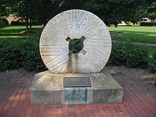 Millstone from one of the earliest settlements in Montoursville, engraved "Otstonwakin, 1768, Montour Preserve"
Madame Montour was the mother of three children. A son, Louis, served as an interpreter during the French and Indian War. He was killed during the war.[5] Her daughter, Margaret, later to be known as "French Margaret" went on to become the leader of "French Margaret's Town" an Indian settlement at the mouth of Lycoming Creek just a few miles up the West Branch Susquehanna River from Montoursville. Her son, Andrew took over leadership of Otstonwakin upon her death in the late 1740s. Andrew inherited his mother’s gift for languages. He spoke French, English, Lenape, Shawnee and the Iroquoian languages. Comfortable with both Native Americans and Europeans, he made a good living as a translator for both settlers and local tribes. In 1742 when Count Zinzendorf met Montour he wrote that Montour looked "decidedly European, and had his face not been encircled with a broad band of paint we would have thought he was one." He also served as an interpreter with Conrad Weiser and Chief Shikellamy. He was granted 880 acres (3.6 km2) of land by the Province of Pennsylvania in the Montoursville area. He later was appointed as a captain in George Washington's Army at Fort Necessity during the French and Indian War. Andrew Montour left Montoursville at some point and moved to Juniata County before finally settling on Mountour's Island in the Allegheny River near Pittsburgh.
Early settlers
Montoursville was incorporated as a borough on February 19, 1850. The history of the borough begins about 40 years prior to its formal incorporation.[3] John Else migrated to the Montoursville area from Bucks County, Pennsylvania in 1807. With his family when he was just ten years old. His father had a farm along Mill Creek in what is now Mill Creek Township. John Else worked to build the first permanent bridge over Loyalsock Creek in 1815. This was the first of many improvements that he held build to establish Montoursville as a viable community in the West Branch Susquehanna River Valley.[6] Else also built many of the structures in Montoursville, including its first permanent home.
John Burrows is recognized as being the founder of Montoursville.[6] He was born near Rahway, New Jersey. In his youth Burrows delivered mail on horseback, riding between New York and Philadelphia. He also served as a courier for General George Washington during the American Revolution for fourteen months. Following the war Burrows migrated to Muncy and worked in the distilling business for several years. His work at the distilleries enabled him to build up the needed capital to make an investment in some land near the mouth of Loyalsock Creek, what is now Montoursville. Burrows also gained a measure of political clout in Lycoming County serving first as a justice of the peace before being elected to the county commissioner's post in 1802 and later to the Pennsylvania State Senate in 1808. He bought 570 acres (2.3 km2) in 1812. Burrows divided his land into lots in 1820 and sold them for $50.00 each.[6] The first buyers of lots in Montoursville divided themselves into two distinct ethnic groups. The Germans settled in the eastern end in a neighborhood that became known as Coffeetown, while the English settled in the western neighborhood that was known as Teatown. In addition to selling the lots in Montoursville Burrows operated a highly successful farm. His produce was sent by raft down the Susquehanna River and onto Baltimore where he was able to turn a profit. Burrowns used these profits to further his enterprise by building the first gristmill in the town. John Burrows continued to sell lots up until the time of his death in 1837.
Nathaniel Burrows, son of John Burrows, was another successful businessman in Montoursville's early days. He opened the first general store in the town. He also received the contract for construction of the West Branch Canal in this section of Lycoming County. Nathaniel Burrows was able to influence the construction of the canal so that it ran further away from the river than usual and thereby closer to the town and the businesses of Nathaniel Burrows.
Indian Park
Indian Park is located on the north-western side of Montoursville and is parallel to Interstate 180/U.S. Route 220. It serves as a large recreational park with several miles of hiking and biking trails, numerous softball fields, picnic areas and pavilions and fishing ponds. Indian Park was a trolley park during the late 19th century and early 20th century. Visitors from Williamsport would board the trolley in downtown Williamsport and ride to Indian Park to spend a day of recreation along the banks of Loyalsock Creek.[6] The park was home to one of the largest and longest roller coasters on the East Coast of the United States. The park also featured over 20 acres (81,000 m2) of ponds, a theatre, and a merry-go-round. The amusement park was ultimately closed in 1924 due in large part to the rising and continued cost of reconstructing the park following the nearly yearly floods on Loyalsock Creek.
TWA Flight 800
Main article: TWA Flight 800 The TWA Flight 800 Memorial
Montoursville became famous worldwide when, on July 17, 1996, TWA Flight 800 exploded off East Moriches, New York, with the loss of 230 lives. On board were 16 students from Montoursville High School and their five adult chaperones who were on a class trip to France as part of a student exchange program.[7]
Condolences came from as far away as Japan, Australia, and Belgium. Governor Tom Ridge attended a vigil at the school with his wife.[8] Ridge and New York City mayor Rudy Giuliani would also attend a memorial service honoring the victims.[9] Among those who sent condolences were President Bill Clinton, the U.S. softball team at the Atlanta Olympics, and François Bujon de l'Estang, French ambassador to the United States (1995–2002).
A memorial is located on the grounds of Montoursville High School. It is a statue of an angel (sculpted by James Barnhill of Asheville, North Carolina) on a base engraved with the names of the 21 local victims and a brief history. The memorial is in a circular grove of 21 trees (one for each victim). The angel was chosen because a cloud seen above the high school on July 21, 1996, was thought by many onlookers to resemble an angel, with 21 small clouds at its feet.
Randolph Hudson of State College was chosen as the memorial designer and Beth Hershberger served as landscape designer.
The five chaperones; Debbie Dickey, a French teacher of the Montoursville Area High School; Doug Dickey, husband of Debbie Dickey; Carol Fry, former school board member; Judith Rupert, high school secretary; Eleanor Wolfson (mother of Wendy Wolfson)
The names of the 16 students are as follows: Jessica Aikey, Daniel Baszczewski, Michelle Bohlin, Jordan Bower, Monica Cox, Claire Gallagher, Julia Grimm, Rance Hettler, Amanda Karschner, Jodi Loudenslager, Cheryl Nibert, Kimberly Rogers, Larissa Uzupis, Jacqueline Watson, Monica Weaver, Wendy Wolfson (daughter of Eleanor Wolfson)
Geography

Loyalsock Loyalsock Picture Rocks Williamsport 
Hughesville  Montoursville

South Williamsport Montgomery Muncy Montoursville is bordered by the West Branch Susquehanna River and Armstrong Township to the south. Loyalsock Creek forms the northern and western border with Loyalsock Township. Fairfield Township borders the borough to the north and east.[10] As the crow flies, Lycoming County is about 130 miles (209 km) northwest of Philadelphia and 165 miles (266 km) east-northeast of Pittsburgh.
Montoursville is located at 41°15′10″N 76°54′56″W / 41.25278°N 76.91556°W (41.252729, -76.915507).[11]
According to the United States Census Bureau, the borough has a total area of 4.2 square miles (10.8 km²).4.0 square miles (10.5 km²) of it is land and 0.1 square miles (0.3 km²) of it (3.12%) is water.
Demographics
As of the census[1] of 2000, there were 4,777 people, 2,067 households, and 1,393 families residing in the borough. The population density was 1,181.0 people per square mile (456.5/km²). There were 2,169 housing units at an average density of 536.3 per square mile (207.3/km²). The racial makeup of the borough was 99.02% White, 0.10% African American, 0.06% Native American, 0.33% Asian, 0.06% from other races, and 0.42% from two or more races. Hispanic or Latino of any race were 0.42% of the population.
There were 2,067 households out of which 28.0% had children under the age of 18 living with them, 53.6% were married couples living together, 10.4% had a female householder with no husband present, and 32.6% were non-families. 29.0% of all households were made up of individuals and 14.7% had someone living alone who was 65 years of age or older. The average household size was 2.31 and the average family size was 2.84.
In the borough the population was spread out with 23.4% under the age of 18, 5.2% from 18 to 24, 26.1% from 25 to 44, 22.6% from 45 to 64, and 22.7% who were 65 years of age or older. The median age was 42 years. For every 100 females there were 90.5 males. For every 100 females age 18 and over, there were 85.4 males.
The median income for a household in the borough was $37,484, and the median income for a family was $44,583. Males had a median income of $33,750 versus $24,449 for females. The per capita income for the borough was $19,648. About 2.4% of families and 4.2% of the population were below the poverty line, including 2.4% of those under age 18 and 5.1% of those age 65 or over.
Education
Montoursville Area School District [1] consists of:
- Loyalsock Valley Elementary School
- Lyter Elementary School
- C.E. McCall Middle School
- Montoursville Area High School
Notable people
- Blaise Alexander, NASCAR driver
- Mike Mussina, baseball player
- Kelly Mazzante, WNBA player
- Tom O'Malley, baseball player
See also
History of Lycoming County, Pennsylvania
References
- ^ a b "American FactFinder". United States Census Bureau. http://factfinder.census.gov. Retrieved 2008-01-31.
- ^ "US Board on Geographic Names". United States Geological Survey. 2007-10-25. http://geonames.usgs.gov. Retrieved 2008-01-31.
- ^ a b *Meginness, John Franklin (1892). History of Lycoming County, Pennsylvania: including its aboriginal history; the colonial and revolutionary periods; early settlement and subsequent growth; organization and civil administration; the legal and medical professions; internal improvement; past and present history of Williamsport; manufacturing and lumber interests; religious, educational, and social development; geology and agriculture; military record; sketches of boroughs, townships, and villages; portraits and biographies of pioneers and representative citizens, etc. etc. (1st Edition ed.). Chicago, IL: Brown, Runk & Co.. ISBN 0-7884-0428-8. http://www.usgennet.org/usa/pa/county/lycoming/history/Chapter-34.html. Retrieved 2007-05-02. "(Note: ISBN refers to Heritage Books July 1996 reprint. URL is to a scan of the 1892 version with some OCR typos)."
- ^ Robin Van Auken. "'Madam' Catherine Montour". Williamsport Sun Gazette. http://www.historicwilliamsport.com/Features/Madam%20Montour.htm. Retrieved 2007-05-02.
- ^ (PDF) A Picture of Lycoming County. The Lycoming County Unit of the Pennsylvania Writers Project of the Work Projects Administration (First edition ed.). The Commissioners of Lycoming County Pennsylvania. 1939. http://www.libraries.psu.edu/do/digitalbookshelf/2799521/. Retrieved 2007-05-02.
- ^ a b c d Don King. "Narrative: Montoursville's history presented by chapter". Christopher Garneau. Archived from the original on 2006-12-09. http://web.archive.org/web/20061209070021/http://montoursville.k12.pa.us/MASD/MontHistory/narrative/narrative1.htm. Retrieved 2007-05-02.
- ^ "National Transportation Safety Board: TWA Flight 800 Report (Retrieved on 2007-05-02)". http://www.ntsb.gov/doclib/reports/2000/aar0003.pdf. Retrieved 2007-07-29.
- ^ "Montoursville mourns loss of 21 killed in crash (Digital Collegian via Archive.Org, July 19, 1996)". http://replay.waybackmachine.org/20080329120426/http://www.collegian.psu.edu/archive/1996_jan-dec/07/07-19-96tdc/07-19-96d01-003.htm. Retrieved 2007-11-23.
- ^ Ravo, Nick (1996-08-18). "Giuliani Shares Montoursville's Sorrow (New York Times, August 18, 1996)". The New York Times. http://query.nytimes.com/gst/fullpage.html?res=9500E5DE1730F93BA2575BC0A960958260&n=Top%2FReference%2FTimes+Topics%2FPeople%2FR%2FRidge%2C+Tom. Retrieved 2007-07-29.
- ^ Pennsylvania Department of Transportation, Bureau of Planning and Research, Geographic Information Division. "2007 General Highway Map Lycoming County Pennsylvania" (Map). 1:65,000. ftp://ftp.dot.state.pa.us/public/pdf/BPR_pdf_files/Maps/GHS/Roadnames/lycoming_GHSN.PDF. Retrieved 2009-12-27.
- ^ "US Gazetteer files: 2010, 2000, and 1990". United States Census Bureau. 2011-02-12. http://www.census.gov/geo/www/gazetteer/gazette.html. Retrieved 2011-04-23.
Municipalities and communities of Lycoming County, Pennsylvania City 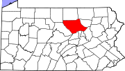
Boroughs Duboistown | Hughesville | Jersey Shore | Montgomery | Montoursville | Muncy | Picture Rocks | Salladasburg | South Williamsport
Townships Anthony | Armstrong | Bastress | Brady | Brown | Cascade | Clinton | Cogan House | Cummings | Eldred | Fairfield | Franklin | Gamble | Hepburn | Jackson | Jordan | Lewis | Limestone | Loyalsock | Lycoming | McHenry | McIntyre | McNett | Mifflin | Mill Creek | Moreland | Muncy Creek | Muncy | Nippenose | Old Lycoming | Penn | Piatt | Pine | Plunketts Creek | Porter | Shrewsbury | Susquehanna | Upper Fairfield | Washington | Watson | Wolf | Woodward
CDPs Faxon | Garden View | Kenmar | Oval | Rauchtown‡
Unincorporated
communitiesGhost town Footnotes ‡This populated place also has portions in an adjacent county
Categories:- Boroughs in Lycoming County, Pennsylvania
- Populated places established in 1820
- 1820 establishments in the United States
- Populated places on the Susquehanna River


Wikimedia Foundation. 2010.