- Darnétal
-
Darnétal

 DarnétalLocation within Upper Normandy region
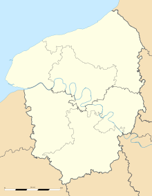 Darnétal
Administration Country France Region Upper Normandy Department Seine-Maritime Arrondissement Rouen Canton Darnétal Intercommunality CREA Mayor Christian Lecerf
(2008–2014)Statistics Elevation 13–143 m (43–469 ft)
(avg. 22 m/72 ft)Land area1 4.93 km2 (1.90 sq mi) Population2 9,531 (2006) - Density 1,933 /km2 (5,010 /sq mi) INSEE/Postal code 76212/ 76160 1 French Land Register data, which excludes lakes, ponds, glaciers > 1 km² (0.386 sq mi or 247 acres) and river estuaries. 2 Population without double counting: residents of multiple communes (e.g., students and military personnel) only counted once. Coordinates: 49°26′43″N 1°09′07″E / 49.4452777778°N 1.15194444444°E
Darnétal is a commune in the Seine-Maritime department in the Haute-Normandie region in northern France.
Contents
Geography
A light industrial suburban town surrounded by woodland, situated some 2 miles (3.2 km) east of the centre of Rouen at the junction of the D43, D15 and the N31 roads. Two small rivers flow through the town, the Robec and the Aubette.
SNCF operates a TER service, having a railway station in the town.Heraldry
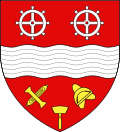
The arms of Darnétal are blazoned :
Gules, a fess wavy [river] between two gear wheels argent and, in base, a printers stamp between, to dexter a weaver's shuttle and its bobbin in saltire, and to sinister a ?linen? shuttle with its ?teasel? in saltire Or.Population
Historical population of Darnétal 1962 1968 1975 1982 1990 1999 2006 9995 11,062 11,765 10,081 9779 9225 9531 From the year 1962 on: population without double counting—residents of multiple communes (e.g. students and military personnel) are counted only once. Places of interest
- The churches of St.Ouen and of St.Pierre, both dating from the sixteenth century.
- Traces of a feudal castle.
- A restored watermill.
Notable people
- The activist René Valentin Binet, (1913–1957) was born here.
See also
References
External links
- Official Darnétal website (French)
- Darnétal Festival website (French)
- Darnétal on the Quid website (French)
Categories:- Communes of Seine-Maritime
- Rouen geography stubs


Wikimedia Foundation. 2010.