- Manéglise
-
Manéglise

 ManégliseLocation within Upper Normandy region
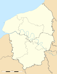 Manéglise
Administration Country France Region Upper Normandy Department Seine-Maritime Arrondissement Le Havre Canton Montivilliers Intercommunality Le Havre Mayor Daniel Soudant
(2001–2008)Statistics Elevation 48–118 m (157–387 ft)
(avg. 66 m/217 ft)Land area1 8.35 km2 (3.22 sq mi) Population2 1,174 (2006) - Density 141 /km2 (370 /sq mi) INSEE/Postal code 76404/ 76133 1 French Land Register data, which excludes lakes, ponds, glaciers > 1 km² (0.386 sq mi or 247 acres) and river estuaries. 2 Population without double counting: residents of multiple communes (e.g., students and military personnel) only counted once. Coordinates: 49°34′01″N 0°15′18″E / 49.567059°N 0.254939°E
Manéglise is a commune in the Seine-Maritime department in the Haute-Normandie region in northern France.
Contents
Geography
A farming village in the Pays de Caux situated some 7 miles (11 km) north of Le Havre, at the junction of the D926 and D52 roads.
Heraldry
The arms of Manéglise are blazoned :
Azure, the local church between in base 3 buckles Or, and in chief a chapé gules, the dexter one charged with 2 stalks of wheat in saltire, the sinister one with 2 leopards Or, overall a chevronel (??) argent on the line of division.Population
Historical population of Manéglise 1962 1968 1975 1982 1990 1999 2006 474 513 604 912 1051 1190 1218 From the year 1962 on: population without double counting—residents of multiple communes (e.g. students and military personnel) are counted only once. Places of interest
- The church of St.Germain, dating from the eleventh century.
- A sixteenth century chapel.
- The château des Hellandes, built in 1904 by Monsieur Levesque on the site of a 17th century manorhouse. It was used as a hospital during World War I.
Twinned with
See also
References
External links
- Manéglise on the Quid website (French)
Categories:- Communes of Seine-Maritime
- Le Havre geography stubs


Wikimedia Foundation. 2010.