- Montville, Seine-Maritime
-
Montville

 MontvilleLocation within Upper Normandy region
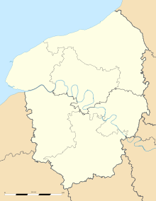 Montville
Administration Country France Region Upper Normandy Department Seine-Maritime Arrondissement Rouen Canton Clères Mayor Pascal Martin (PR)
(2008–2014)Statistics Elevation 42–178 m (138–584 ft)
(avg. 51 m/167 ft)Land area1 10.85 km2 (4.19 sq mi) Population2 4,539 (2006) - Density 418 /km2 (1,080 /sq mi) INSEE/Postal code 76452/ 76710 1 French Land Register data, which excludes lakes, ponds, glaciers > 1 km² (0.386 sq mi or 247 acres) and river estuaries. 2 Population without double counting: residents of multiple communes (e.g., students and military personnel) only counted once. Coordinates: 49°32′50″N 1°04′35″E / 49.5472222222°N 1.07638888889°E
Montville is a commune in the Seine-Maritime department in the Haute-Normandie region in northern France.
Contents
Geography
A small town of forestry farming and light industry situated some 9 miles (14 km) north of Rouen at the junction of the D44, D51 and the D155 roads. SNCF operates a TER (train) train service here. Two small rivers meet here, the Clérette and the Cailly.
Heraldry
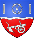
The arms of Montville are blazoned :
Per fess wavy azure and gules, a barrulet wavy between (in chief) in fess, a toothed wheel between 2 weavers shuttles palewise, and (in base) a plough argent.Population
Population history 1962 1968 1975 1982 1990 1999 2006 4057 4139 4111 4365 4252 4644 4539 Starting in 1962: Population without duplicates Places of interest
- The church of Notre-Dame, dating from the eleventh century.
- A seventeenth century chapel.
- The chateau, dating from the nineteenth century.
- The National Firefighters Museum.
- Several interesting old buildings dating from the seventeenth century.
- The mairie, housing a tricolor dating from 1789.
Twin towns
See also
References
External links
- Official website of Montville (French)
- Museum of the Sapeurs Pompiers (French)
- Montville on the Quid website (French)
Categories:- Communes of Seine-Maritime
- Rouen geography stubs


Wikimedia Foundation. 2010.