- Coal Center, Pennsylvania
-
Coal Center Borough Country United States State Pennsylvania County Washington Coordinates 40°4′11″N 79°54′3″W / 40.06972°N 79.90083°W Area 0.1 sq mi (0 km2) Population 134 (2000) Density 1,178.5 / sq mi (455 / km2) Established 1814 Mayor Frank Paterra Timezone EST (UTC-4) - summer (DST) EDT (UTC-5) Area code 724 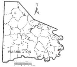 Location of Coal Center in Washington County
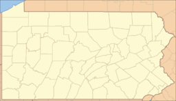
 Location of Coal Center in Pennsylvania
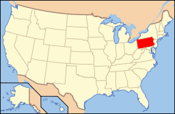 Location of Pennsylvania in the United States
Coal Center is a borough in Washington County, Pennsylvania, along the Monongahela River. The population was 134 at the 2000 census.
Geography
Coal Center is located at 40°4′11″N 79°54′3″W / 40.06972°N 79.90083°W (40.069810, -79.900783)[1].
According to the United States Census Bureau, the borough has a total area of 0.1 square miles (0.26 km2), of which, 0.1 square miles (0.26 km2) of it is land and 0.04 square miles (0.10 km2) of it (14.29%) is water.
Demographics
As of the census[2] of 2000, there were 134 people, 59 households, and 32 families residing in the borough. The population density was 1,178.5 people per square mile (470.3/km²). There were 72 housing units at an average density of 633.2 per square mile (252.7/km²). The racial makeup of the borough was 96.27% White, and 3.73% from two or more races. Hispanic or Latino of any race were 1.49% of the population. 10.5% were of Polish, 10.5% Russian, 8.9% English, 8.9% German, 8.9% Irish, 8.1% Croatian and 6.5% Italian ancestry according to Census 2000.
There were 59 households out of which 22.0% had children under the age of 18 living with them, 28.8% were married couples living together, 25.4% had a female householder with no husband present, and 44.1% were non-families. 25.4% of all households were made up of individuals and 15.3% had someone living alone who was 65 years of age or older. The average household size was 2.27 and the average family size was 2.79.
In the borough the population was spread out with 17.2% under the age of 18, 20.1% from 18 to 24, 20.1% from 25 to 44, 24.6% from 45 to 64, and 17.9% who were 65 years of age or older. The median age was 38 years. For every 100 females there were 69.6 males. For every 100 females age 18 and over, there were 58.6 males.
The median income for a household in the borough was $23,125, and the median income for a family was $28,125. Males had a median income of $26,250 versus $11,042 for females. The per capita income for the borough was $13,827. There were 18.2% of families and 28.1% of the population living below the poverty line, including 30.8% of under eighteens and 20.0% of those over 64.
References
- ^ "US Gazetteer files: 2010, 2000, and 1990". United States Census Bureau. 2011-02-12. http://www.census.gov/geo/www/gazetteer/gazette.html. Retrieved 2011-04-23.
- ^ "American FactFinder". United States Census Bureau. http://factfinder.census.gov. Retrieved 2008-01-31.
Categories:- Boroughs in Washington County, Pennsylvania
- Populated places established in 1814
- Pittsburgh metropolitan area


Wikimedia Foundation. 2010.