- Lake Corangamite
-
Lake Corangamite 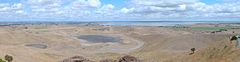
Shoreline southwest of Foxhow Coordinates 38°10′S 143°23′E / 38.167°S 143.383°ECoordinates: 38°10′S 143°23′E / 38.167°S 143.383°E Lake type endorheic, hypersaline Primary inflows Pirron Yalloak Creek, Woady Yaloak River, Salt Creek, various springs (3 m³/s) Primary outflows evaporation Catchment area 4079 km²[1] Basin countries Australia Max. length 150 km Surface area 234 km² Average depth 5 m (average when full) Max. depth 7 m Islands Vaughan Island Settlements none References [1] Lake Corangamite is Victoria’s largest natural lake, located near Colac in south-west Victoria, Australia in the Lakes and Craters region of the Victorian Volcanic Plains. The lake is hypersaline, and salinity levels have increased dramatically as the lake level has dropped in recent decades. It is Australia's largest permanent saline lake, covering approximately 230 km2 with a circumference of about 150 km.[2] It forms part of the Ramsar-listed Western District Lakes wetland site.
Contents
Physical features and hydrology
The waterbody is surrounded to the south and east by rocky outcrops (known locally as the stony rises) which were formed by lava flows from Mount Porndon to the south-west and Mount Warrion to the east. The spectacular 'Red Rocks' maar crater complex overlooks the south west shore. The Mount Warrion flows caused the lake to form by blocking drainage to the east.
As is typical of lakes in the area, the eastern flanks of the lake consist of lunettes formed by wind borne sediments blown from the lake during periods with dry climates.
Flow into the lake is extremely variable and negligible in the driest years. Currently it is endorheic (there is no outflow) but during the wet decade of the 1950s the lake flooded and became connected via a series of wetlands and lakes to Lake Murdeduke and the Barwon River. It has never been completely dry since European settlement, and there it is evidence it was an open lake for centuries prior to the when 1840s rainfall and runoff were similar to those of the 1950s.[3]
The main inflows are from Pirron Yaloak Creek flowing from the Otway plains to the south, the Woady Yaloak River flowing from the flanks of the Victorian midlands to the north, and Salt Creek flowing from the plains to the north-west. The Pirron Yaloak has high nutrient loads due to dairy farming in its catchment.
In response to the floods of the 1950s, the Woady Yalloak was diverted away from Lake Corangamite and into the Barwon River. The diversion is managed on the basis of a trigger level for the lake, above which the diversion is enacted. This has not occurred in recent years. Levels have been dropping for decades and it is possible that it will dry completely. In 1980 the salinity was approximately that of seawater[4] and has since risen at least 4x that of seawater.[5]
Fauna
Fish
Aquatic fauna once included fish species such as Short-finned Eel, Common Galaxias, Flat-headed Gudgeon and Small-mouth Hardyhead. These may still survive in refuges such as Pirron Yaloak creek and various freshwater springs flowing from the stony rises on the south west side of the lake. Springs on the south east side have dried - possibly due to over exploitation of the Warrion Aquifer for irrigation. More recently the fauna included brine shrimp and a species of isopod.
Birds
In the past the lake has supported internationally-significant numbers of Banded Stilts.[2] The lake was previously an important breeding site for waterbirds. Most recently Pelican colonies occurred at Wool Wool rocks and Vaughn Island. However, as water levels have dropped, prey have disappeared and foxes have gained access to the colonies, which have now been abandoned. After receiving substantial grants from the government to undertake conservation works, the owner of Vaugn Island used earth moving equipment to remove habitat such as rocks and remnant vegetation. The lake forms part of the Lake Corangamite Complex Important Bird Area, so identified by BirdLife International because it sometimes supports globally important numbers of waterbirds.[6]
World War II Aircraft
A crashed World War II RAAF Wirraway was discovered in early June 2005 in Lake Corangamite. Heritage Victoria protects all aircraft crash sites over 50 years old as historic archaeological sites, and the RAAF has been briefed on the find. The site was recently exposed by receding water levels in the Lake and reported by Parks Victoria officers to Heritage Victoria. The site appears intact and remains mostly submerged. This plane is believed to be an RAAF Wirraway Serial No. A20-405 that is recorded as having crashed into Lake Corangamite, 400 metres from shore on 17 March 1943. There were at least 355 military aircraft crashes recorded in Victoria during World War II, most of them the result of training incidents. Wirraways were the first aircraft to be mass manufactured in Australia, and this eighteen years before the first mass manufactured Australian car. Between 1939 and 1946 the Commonwealth Aircraft Corporation (CAC) produced 755 Wirraways for use as a general purpose trainer, though they saw action in the desperate defence of Malaya and Papua New Guinea where they were lost at an appalling rate to superior Japanese Mitsubishi A6M Zero fighters. Only eight Wirraways are still in existence as restored or partly restored historic aircraft.[7]
Notes
- ^ a b An Audit of the Ecological Condition of Australian Rivers
- ^ a b Australian Nature Conservation Agency. (1996). Directory of Importanr Wetlands in Australia. (2nd edition, pp.728-9). ANCA: Canberra. ISBN 0-642-21378-X
- ^ Water Research Foundation of Australia; 1975 symposium: the 1973-4 floods in rural and urban communities; published 1975
- ^ W. D. Williams (1995) - Lake Corangamite, Australia, a permanent saline lake: Conservation and management issues. Lakes & Reservoirs: Research & Management 1 (1), 55–64.
- ^ Age Newspaper article - Saltwater haven turns to dust as big dry bites hard
- ^ BirdLife International. (2011). Important Bird Areas factsheet: Lake Corangamite Complex. Downloaded from http://www.birdlife.org on 2011-07-19.
- ^ http://www.aima.iinet.net.au/publications/newsletters/docs/NLv24n2y05.pdf
See also
- List of Ramsar sites in Australia
- Ramsar Convention
External links
Categories:- Lakes of Victoria (Australia)
- Endorheic lakes of Australia
- Ramsar sites in Australia
- Geography of Geelong
- Colac, Victoria
- Volcanoes of Victoria (Australia)
- Maars of Australia
- Important Bird Areas of Australia

Wikimedia Foundation. 2010.