- Charlestown, Rhode Island
-
Charlestown, Rhode Island — Town — Location of Charlestown in Washington County, Rhode Island
Coordinates: 41°23′7″N 71°40′5″W / 41.38528°N 71.66806°WCoordinates: 41°23′7″N 71°40′5″W / 41.38528°N 71.66806°W Country United States State Rhode Island County Washington Area – Total 59.3 sq mi (153.6 km2) – Land 36.8 sq mi (95.4 km2) – Water 22.5 sq mi (58.1 km2) Elevation 59 ft (18 m) Population (2010) – Total 7,827 – Density 212.7/sq mi (82.0/km2) Time zone Eastern (EST) (UTC-5) – Summer (DST) EDT (UTC-4) ZIP code 02813 Area code(s) 401 FIPS code 44-14500[1] GNIS feature ID 1220080[2] 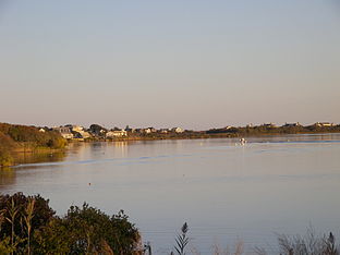
Charlestown is a town in Washington County, Rhode Island, United States. The population was 7,827 at the 2010 census.
Contents
History
Charlestown is named after King Charles II, and was incorporated in 1738. The area was formerly part of the town of Westerly. It was in turn divided and the part north of the Pawcatuck River became the town of Richmond in 1747.
Geography
According to the United States Census Bureau, the town has a total area of 59.3 square miles (154 km2), of which, 36.8 square miles (95 km2) of it is land and 22.5 square miles (58 km2) of it (37.86%) is water.
Demographics
As of the census[1] of 2000, there were 7,859 people, 3,178 households, and 2,278 families residing in the town. The population density was 213.3 people per square mile (82.4/km²). There were 4,797 housing units at an average density of 130.2 per square mile (50.3/km²). The racial makeup of the town was 96.26% White, 0.38% African American, 1.26% Native American, 0.61% Asian, 0.03% Pacific Islander, 0.53% from other races, and 0.93% from two or more races. Hispanic or Latino of any race were 1.11% of the population.
There were 3,178 households out of which 28.3% had children under the age of 18 living with them, 60.4% were married couples living together, 7.8% had a female householder with no husband present, and 28.3% were non-families. 21.8% of all households were made up of individuals and 8.1% had someone living alone who was 65 years of age or older. The average household size was 2.46 and the average family size was 2.88.
In the town the population was spread out with 21.8% under the age of 18, 6.3% from 18 to 24, 29.4% from 25 to 44, 28.0% from 45 to 64, and 14.5% who were 65 years of age or older. The median age was 41 years. For every 100 females there were 98.2 males. For every 100 females age 18 and over, there were 98.5 males.
The median income for a household in the town was $51,491, and the median income for a family was $56,866. Males had a median income of $40,616 versus $29,474 for females. The per capita income for the town was $25,642. About 3.0% of families and 5.1% of the population were below the poverty line, including 4.7% of those under age 18 and 4.7% of those age 65 or over.
Politics
Charlestown is the headquarters for the Narragansett Indian Tribe.[3]
Parks and recreation
Charlestown has a number of different recreational activities, such as basketball, soccer, little league baseball, and football. After sixth grade, school-sponsored sports are offered at the Chariho Regional District Middle and High School.
Ninigret Park, the former site of Charlestown NAAS, resides in Charlestown. It is a popular place for recreational sports games. There is also an observatory and wildlife refuge within the park. This area is also used for a majority of the large events such as the Seafood Festival and Big Apple Circus.
Seafood Festival
The Charlestown, RI Chamber of Commerce holds an annual seafood and lobster festival in the first week of August. Local businesses and vendors set up booths for various seafood based events. There is a large draw of locals and "out-of-staters" to this event.
Rocket experiments
Since 1965 from Charlestown some sounding rockets were launched from 41°22′N 71°40′W / 41.367°N 71.667°W. The biggest campaign took place on May 30, 1965 in order to watch a solar eclipse.
National Historic Places in Charlestown
- Babcock House
- District Schoolhouse No. 2
- Fort Ninigret
- Foster Cove Archeological Site
- Historic Village of the Narragansetts in Charlestown
- Indian Burial Ground
- Joseph Jeffrey House
- Shannock Historic District
- Sheffield House
- Joseph Stanton House
References
- ^ a b "American FactFinder". United States Census Bureau. http://factfinder.census.gov. Retrieved 2008-01-31.
- ^ "US Board on Geographic Names". United States Geological Survey. 2007-10-25. http://geonames.usgs.gov. Retrieved 2008-01-31.
- ^ "Tribal Governments by Area." National Congress of American Indians. (retrieved 26 June 2010)
Municipalities and communities of Washington County, Rhode Island Towns Charlestown | Exeter | Hopkinton | Narragansett | New Shoreham | North Kingstown | Richmond | South Kingstown | Westerly

CDPs Other
villagesAlton | Carolina | Kingston | Peace Dale | Point Judith | Quonochontaug | Saunderstown | Usquepaug | Wakefield | Watch Hill | Wickford | Wyoming
 State of Rhode Island and Providence Plantations
Topics Culture | Delegations | Geography | Government | History | Thirteen Colonies | Colonial Colleges | Images | Narragansett Indian Tribe | People | Visitor attractions | State symbols
Regions Counties: Bristol | Kent | Newport | Providence | Washington | Geographic: Blackstone Valley | Block Island
Cities Central Falls | Cranston | East Providence | Newport | Pawtucket | Providence | Warwick | Woonsocket
Towns Barrington | Bristol | Burrillville | Charlestown | Coventry | Cumberland | East Greenwich | Exeter | Foster | Glocester | Hopkinton | Jamestown | Johnston | Lincoln | Little Compton | Middletown | Narragansett | New Shoreham (Block Island) | North Kingstown | North Providence | North Smithfield | Portsmouth | Richmond | Scituate | Smithfield | South Kingstown | Tiverton | Warren | Westerly | West Greenwich | West Warwick
Categories:- Towns in Rhode Island
- Populated places in Washington County, Rhode Island
- Populated coastal places in Rhode Island
- Charlestown, Rhode Island


Wikimedia Foundation. 2010.