Obi Islands

Obi Islands
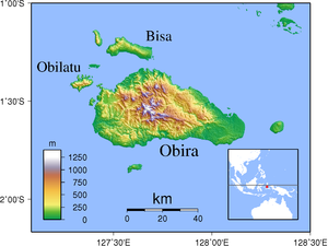
Topographic map of Obi Islands
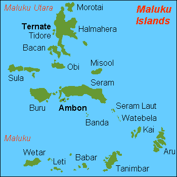
Location map of Obi Islands among the Maluku Islands

The Obi Islands (also known as Ombirah,[1] Indonesian Kepulauan Obi) are a group of islands in the Indonesian province of Maluku. They lie north of Buru and Ceram.

The largest in the group is Obi Island. Nearby are the islands of Bisa, Gomumu, Obilatu, Tapat, Tobalai.

Notes

  1. ^ Goodall, George (Editor)(1943) Philips' International Atlas London, George Philip and Son map 'East Indies' pp.91-92

Coordinates: 1°30′S 127°45′E / 1.5°S 127.75°E / -1.5; 127.75


Wikimedia Foundation. 2010.

Игры ⚽ Нужен реферат?

Look at other dictionaries:

  • Obi Islands — ▪ islands, Indonesia also called  Ombi Islands         group of the northern Moluccas, Maluku Utara (North Moluccas) provinsi (province), Indonesia. They lie south of Halmahera Island, north of Ceram Island, and east of the Sula Islands. The… …   Universalium

  • Obi — may refer to: Obi (sash), a sash worn with a kimono or with the uniforms used by practitioners of Japanese martial arts Obi Wan Kenobi, fictional character from the Star Wars universe Obi (store), a European home improvement store chain based in… …   Wikipedia

  • Islands of Indonesia — Indonesia comprises 17,508 islands (based from Seminar Nasional Penetapan Nama Pulau pulau Kecil Dalam Presektif Sejarah or National Seminary of Name For Little Islands From History Side , July 16 to 18 at Palembang, South Sumatra, Indonesia, now …   Wikipedia

  • Obi Ikechukwu Charles — when he was playing for FC Suðuroy Obi Ikechukwu Charles (born 2 Jan 1985) is a Nigerian professional football player, a striker. He currently plays for Yangon United FC. In the first half of 2010 he played for FC Suðuroy in the Faroe Islands …   Wikipedia

  • Obi of Onitsha — The Obi of Onitsha is the traditional leader of Onitsha, Anambra State, southeast Nigeria. The post of the Obi is recognised by the state and federal governments of Nigeria, and the Obi himself is seen as a representative of the people of Onitsha …   Wikipedia

  • Maluku Islands — Maluku redirects here. For the Indonesian provinces encompassing the islands, see Maluku (province) and North Maluku. Maluku Island within Indonesia yellow : North Maluku province red : Maluku province …   Wikipedia

  • List of islands of Indonesia — Map of Indonesia This is a list of islands of Indonesian Archipelago. Indonesia comprises 17,508 18,306 islands and 8,844 that have been named according to estimates made by the Government of Indonesia, with 922 of those permanently inhabited.[1] …   Wikipedia

  • hawaiian islands — Гавайские острова Aru Islands острова Ару Obi Islands острова Оби Aran Islands острова Аран Cook Islands острова Кука Line Islands острова Лайн …   English-Russian travelling dictionary

  • Aru Islands — Location of the Aru Islands among surrounding islands of eastern Indonesia Location of the Ar …   Wikipedia

  • Kay Islands — Lage der Kai Inseln Die Kai Inseln oder Kei Inseln (engl. Kai Islands) befinden sich im südöstlichen Bereich der Molukken in der indonesischen Provinz Maluku. Inhaltsverzeichnis 1 Geografie 2 Fauna …   Deutsch Wikipedia

Share the article and excerpts

Direct link
Do a right-click on the link above
and select “Copy Link”