North-Eastern Swiss Alps

North-Eastern Swiss Alps

This article focuses on the part of the Alps and Pré-Alps that is located in North-Eastern Switzerland. This region is bordered by: Lake Lucerne in the south-west; the Klausen Pass, upper Linth valley and Lake Walen in the south; the Rhine valley in the east; Lake Constance in the north.

Peaks

The chief peaks of the Swiss (Pre-)Alps, north of the Klausen Pass, are:
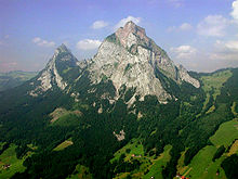
Grosser Mythen
Name Elevation (m) Elevation (ft)
Glärnisch (highest) 2,920 9,580
Bös Fulen (Böser Faulen) 2,804 9,199
Säntis 2,504 8,215
Altmann 2,438 7,999
Faulfirst 2,416 7,927
Alvier 2,363 7,753
Churfirsten (highest) 2,309 7,575
Speer 1,954 6,411
Grosser Mythen 1,902 6,240
Rigikulm 1,800 5,900
Hoher Kasten 1,798 5,899
Rossberg 1,583 5,194
Zugerberg Hochwacht 992 3,255
Albis Hochwacht 880 2,890
Uetliberg 873 2,864

Passes

The chief passes of the Swiss Alps, north of the Klausen Pass, are:

Note: road status as of 1911.
Mountain pass location type (as of 1911) elevation (m) elevation (ft)
Ruosalperkulm Schächen Valley to the Muota Valley foot path 2,172 7,126
Karren Alp Pass Muota Valley to Linthal foot path 2,096 6,877
Kinzigkulm Pass Schächen Valley to the Muota Valley foot path 2,076 6,811
Saasberg Pass Einsiedeln to Glarus foot path 1,898 6,227
Kamor Pass Appenzell to Rüthi bridle path 1,680 5,510
Saxerlücke Appenzell to Sax foot path 1,651 5,417
Schwein Alp Pass Wägital (Wäggithal) to bridle path 1,572 5,157
Pragel Pass Muotathal to Glarus carriage road in progress 1,554 5,098
Hacken Pass Schwyz to Einsiedeln foot path 1,417 4,649
Holzegg Pass Schwyz to Einsiedeln bridle path 1,407 4,616
Ibergeregg Pass Schwyz to Iberg and Einsiedeln carriage road 1,406 4,613
Krazeren Pass Nesslau to Urnäsch bridle path 1,217 3,993

See also

 This article incorporates text from a publication now in the public domainChisholm, Hugh, ed (1911). Encyclopædia Britannica (11th ed.). Cambridge University Press. 


Wikimedia Foundation. 2010.

Игры ⚽ Нужен реферат?

Look at other dictionaries:

  • Swiss Alps — Satellite image of Switzerland in October 2002. On the north side of the Alps, the regions located above 2000 m are covered by snow. The canton of Ticino (on the south side) is almost snow free in early autumn. The Swiss Alps (German: Schweizer… …   Wikipedia

  • Alps — /alps/, n. (used with a pl. v.) a mountain range in S Europe, extending from France through Switzerland and Italy into Austria, Slovenia, and Croatia. Highest peak, Mont Blanc, 15,781 ft. (4810 m). * * * I Mountain system, south central Europe.… …   Universalium

  • Swiss plateau — Satellite image of the Swiss plateau between the Jura and the Alps The Swiss Plateau or Central Plateau (plateau suisse in French, Schweizer Mittelland in German, altipiano svizzero in Italian) constitutes one of the three major landscapes in… …   Wikipedia

  • Alps — Alpe redirects here. For the German river, see Alpe (river). For other uses, see Alps (disambiguation). Alps Range The …   Wikipedia

  • Swiss German — Infobox Language name=Swiss German nativename=Schwyzerdütsch familycolor=Indo European pronunciation= [ʃvitsəɾd̥ytʃ] states=Switzerland, Italy, Liechtenstein, Austria (Vorarlberg) region=Europe speakers=4,500,000 fam2=Germanic fam3=West Germanic… …   Wikipedia

  • Geography of the Alps — The Alps cover a large area. This article describes the delimitation of the Alps as a whole and of subdivisions of the range, follows the course of the main chain of the Alps and discusses the lakes and glaciers found in the region.The Alps form… …   Wikipedia

  • Graian Alps — Geobox|Range name=Graian Alps image caption=Mont Blanc area, Mer de Glace in foreground country=France | country1=Italy | country2=Switzerland region=Savoie | region1=Piedmont | region2=Aosta Valley | region3=Valais parent=Alps border=Chablais… …   Wikipedia

  • Glarus Alps — Geobox|Range name=Glarus Alps other name= fr. Alpes glaronaises other name1= de. Glarner Alpen image caption=Tödi country=Switzerland region type=Cantons region=Glarus| region1=Uri | region2=Graubünden region3=St Gallen unit=Alps border=Urner… …   Wikipedia

  • Lepontine Alps — Geobox|Range name=Lepontine Alps other name= fr. Alpes lépontines other name1= de. Lepontinische Alpen other name2= it. Alpi Lepontine image caption=Monte Leone country=Switzerland | country1=Italy region=Valais| region1=Ticino|… …   Wikipedia

  • Geology of the Alps — The Alps form a part of a Tertiary orogenic belt of mountain chains, called the Alpide belt, that stretches through southern Europe and Asia from the Atlantic all the way to the Himalayas. This belt of mountain chains was formed during the Alpine …   Wikipedia

Share the article and excerpts

Direct link
Do a right-click on the link above
and select “Copy Link”