- Crosbyton, Texas
-
Crosbyton, Texas — City — The Crosby County Courthouse in Crosbyton.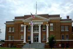 Location of Crosbyton, Texas

Coordinates: 33°39′24″N 101°14′20″W / 33.65667°N 101.23889°WCoordinates: 33°39′24″N 101°14′20″W / 33.65667°N 101.23889°W Country United States State Texas County Crosby Incorporated (city) 1917 Government – Type Mayor-Council – Mayor Joe Hargrove Area – Total 2.1 sq mi (5.5 km2) – Land 2.1 sq mi (5.5 km2) – Water 0.0 sq mi (0.0 km2) Elevation 3,022 ft (921 m) Population (2000) – Total 1,874 – Density 886.9/sq mi (342.4/km2) Time zone Central (CST) (UTC-6) – Summer (DST) CDT (UTC-5) ZIP code 79322 Area code(s) 806 FIPS code 48-17768[1] GNIS feature ID 1355398[2] Website www.crosbytontexas.org Crosbyton is a city in and the county seat of Crosby County, Texas, United States.[3] The population was 1,874 at the 2000 census. Crosbyton is part of the Lubbock Metropolitan Statistical Area.
Former Crosby County administrative County Judge Joseph P. Heflin represented District 85 in the Texas House of Representatives from 2007-2011. During his tenure Heflin was the only Democrat from either West Texas or the Panhandle serving in the legislature. He was unseated in the 2010 general election by the Republican Jim Landtroop of Plainview in Hale County. In 2006, Heflin had defeated Landtroop by fewer than 225 votes.
Contents
History
The city was named for land office commissioner Stephen Crosby.[4]
Geography
Crosbyton is located at 33°39′24″N 101°14′20″W / 33.65667°N 101.23889°W (33.656733, -101.238811)[5].
According to the United States Census Bureau, the city has a total area of 2.1 square miles (5.4 km2), all of it land.
Demographics
As of the census[1] of 2000, there were 1,874 people, 677 households, and 482 families residing in the city. The population density was 886.9 people per square mile (342.9/km²). There were 781 housing units at an average density of 369.6 per square mile (142.9/km²). The racial makeup of the city was 62.49% White, 5.71% African American, 0.21% Native American, 0.05% Asian, 30.15% from other races, and 1.39% from two or more races. Hispanic or Latino of any race were 47.65% of the population.
There were 677 households out of which 34.6% had children under the age of 18 living with them, 55.8% were married couples living together, 11.1% had a female householder with no husband present, and 28.8% were non-families. 27.3% of all households were made up of individuals and 17.6% had someone living alone who was 65 years of age or older. The average household size was 2.68 and the average family size was 3.26.
In the city the population was spread out with 28.8% under the age of 18, 8.8% from 18 to 24, 24.3% from 25 to 44, 20.8% from 45 to 64, and 17.4% who were 65 years of age or older. The median age was 36 years. For every 100 females there were 85.9 males. For every 100 females age 18 and over, there were 82.4 males.
The median income for a household in the city was $24,722, and the median income for a family was $30,900. Males had a median income of $22,647 versus $18,000 for females. The per capita income for the city was $16,329. About 23.7% of families and 28.0% of the population were below the poverty line, including 36.9% of those under age 18 and 25.9% of those age 65 or over.
Education
The City of Crosbyton is served by the Crosbyton Consolidated Independent School District.
See also
- Llano Estacado
- Mount Blanco
- Blanco Canyon
- White River (Texas)
References
- ^ a b "American FactFinder". United States Census Bureau. http://factfinder.census.gov. Retrieved 2008-01-31.
- ^ "US Board on Geographic Names". United States Geological Survey. 2007-10-25. http://geonames.usgs.gov. Retrieved 2008-01-31.
- ^ "Find a County". National Association of Counties. http://www.naco.org/Counties/Pages/FindACounty.aspx. Retrieved 2011-06-07.
- ^ "Profile for Crosbyton, Texas". ePodunk. http://www.epodunk.com/cgi-bin/genInfo.php?locIndex=26325. Retrieved 2010-06-15.
- ^ "US Gazetteer files: 2010, 2000, and 1990". United States Census Bureau. 2011-02-12. http://www.census.gov/geo/www/gazetteer/gazette.html. Retrieved 2011-04-23.
Municipalities and communities of Crosby County, Texas County seat: CrosbytonCities 
Unincorporated
communitiesCone | Kalgary
Ghost town Estacado
County seats of Texas A B Baird · Ballinger · Bandera · Bastrop · Bay City · Beaumont · Beeville · Bellville · Belton · Benjamin · Big Lake · Big Spring · Boerne · Bonham · Boston · Brackettville · Brady · Breckenridge · Brenham · Brownfield · Brownsville · Brownwood · Bryan · BurnetC Caldwell · Cameron · Canadian · Canton · Canyon · Carrizo Springs · Carthage · Center · Centerville · Channing · Childress · Clarendon · Clarksville · Claude · Cleburne · Coldspring · Coleman · Colorado City · Columbus · Comanche · Conroe · Cooper · Corpus Christi · Corsicana · Cotulla · Crane · Crockett · Crosbyton · Crowell · Crystal City · CueroD E F Fairfield · Falfurrias · Farwell · Floresville · Floydada · Fort Davis · Fort Stockton · Fort Worth · Franklin · FredericksburgG Gail · Gainesville · Galveston · Garden City · Gatesville · George West · Georgetown · Giddings · Gilmer · Glen Rose · Goldthwaite · Goliad · Gonzales · Graham · Granbury · Greenville · Groesbeck · Groveton · GuthrieH Hallettsville · Hamilton · Haskell · Hebbronville · Hemphill · Hempstead · Henderson · Henrietta · Hereford · Hillsboro · Hondo · Houston · HuntsvilleJ K L M N O P Paducah · Paint Rock · Palestine · Palo Pinto · Panhandle · Paris · Pearsall · Pecos · Perryton · Pittsburg · Plains · Plainview · Port Lavaca · PostQ R Rankin · Raymondville · Refugio · Richmond · Rio Grande City · Robert Lee · Roby · Rockport · Rocksprings · Rockwall · RuskS San Angelo · San Antonio · San Augustine · San Diego · San Marcos · San Saba · Sanderson · Sarita · Seguin · Seminole · Seymour · Sherman · Sierra Blanca · Silverton · Sinton · Snyder · Sonora · Spearman · Stanton · Stephenville · Sterling City · Stinnett · Stratford · Sulphur Springs · SweetwaterT, U V, W, Z Van Horn · Vega · Vernon · Victoria · Waco · Waxahachie · Weatherford · Wellington · Wharton · Wheeler · Wichita Falls · Woodville · ZapataCategories:- Cities in Texas
- Populated places in Crosby County, Texas
- County seats in Texas
- Lubbock metropolitan area


Wikimedia Foundation. 2010.