- El Paso, Texas
-
"El Paso" redirects here. For other uses, see El Paso (disambiguation).
City of El Paso — City — From top left to bottom right: Downtown El Paso, Franklin Mountains, El Paso Museum of Art exterior, city intersection, UT El Paso, El Paso Zoo

Flag
SealLocation in the state of Texas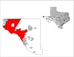 Location in the state of Texas
 El Paso
Coordinates: 31°47′25″N 106°25′24″W / 31.79028°N 106.42333°WCoordinates: 31°47′25″N 106°25′24″W / 31.79028°N 106.42333°W Country United States State Texas County El Paso Metropolitan Area El Paso-Las Cruces-Ciudad Juarez Metropolitan Area Government – Mayor John Cook Area – City 250.5 sq mi (648.8 km2) – Land 249.08 sq mi (645.11 km2) – Water 1.46 sq mi (3.78 km2) Elevation 3,740 ft (1,140 m) Population (2010[1]) – City 649,121 (19th) – Density 2,446.7/sq mi (944.7/km2) – Metro 800,647 Time zone MST (UTC-7) – Summer (DST) MDT (UTC-6) ZIP codes 79900-79999,
88500-88599 (PO Boxes)Area code(s) 915 FIPS code 48-24000[2] GNIS feature ID 1380946[3] Website www.elpasotexas.gov El Paso, (pronounced /ɛlˈpæsoʊ/) is a city in and the county seat of El Paso County, Texas, United States, and lies in far West Texas. In the 2010 census, the city had a population of 649,121.[1] It is the sixth largest city in Texas and the 19th largest city in the United States. Its metropolitan area covers all of El Paso County, whose population in the 2010 census was 800,647.[1]
El Paso stands on the Rio Grande (Río Bravo del Norte), across the border from Ciudad Juárez, Chihuahua, Mexico. The image to the right shows Downtown El Paso and Juárez, with the Juárez Mountains in the background. The two cities form a combined international metropolitan area, sometimes called Juarez-El Paso, with Juárez being the significantly larger of the two in population. Together they have a combined population of 2 million, with Juárez accounting for 2/3 of the population. In 2010 El Paso was awarded an All-America City Award, the oldest community recognition program in the United States.
El Paso is home to the University of Texas at El Paso (founded in 1914 as The Texas State School of Mines and Metallurgy, and later, Texas Western College; its present name dates from 1967) and the Texas Tech University Health Sciences Center at El Paso. Fort Bliss, one of the largest military complexes of the United States Army, lies to the east and northeast of the city, with training areas extending north into New Mexico, up to the White Sands Missile Range and neighboring Holloman Air Force Base in Alamogordo. The Franklin Mountains extend into El Paso from the north and nearly divide the city into two sections, the western half forming the beginnings of the Mesilla Valley and with the eastern slopes connecting in the central business district at the south end of the mountain range.
Contents
History
Main article: History of El Paso, TexasThe El Paso region has had human settlement for thousands of years, as evidenced by Folsom points from hunter-gatherers found at Hueco Tanks.[4] The earliest known cultures in the region were maize farmers. At the time of the arrival of the Spanish the Manso, Suma, and Jumano tribes populated the area and were subsequently incorporated into the Mestizo culture in the area, along with immigrants from central Mexico, captives from Comanchería, and genízaros of various ethnic groups. The Mescalero Apache roamed the region as well.
Spanish explorer Don Juan de Oñate was the first European explorer known to have arrived at the Rio Grande near El Paso, in 1598,[5] celebrating Thanksgiving Mass there on April 30, 1598 (several decades before the Pilgrims' Thanksgiving). However, it is thought that the 4 survivors of the Narváez expedition passed through the area in the mid-1530s.[6] El Paso del Norte (the present day Ciudad Juárez), was founded on the south bank of the Río Bravo del Norte, (Rio Grande) in 1659 by Spanish conquistadors. In 1680 the small village of El Paso became the base for Spanish governance of the territory of New Mexico, remaining the largest settlement in New Mexico until its cession to the US in 1848, when Texas took it in 1850.
 Map of the city in 1886.
Present day El Paso City largely remained undeveloped during most of Spanish control. Instead, Spanish settlement was centered on El Paso del Norte (the present day Ciudad Juárez). Although, the Spanish Crown and the local authorities of El Paso del Norte had made several land concessions to bring agricultural production to the northern bank of the river in present day El Paso City, continual Indian raids and warfare overwhelmed any attempts. The Apache Wars and subsequent Comanche Wars left northern Mexico, then including present day New Mexico, Texas, Coahuila, in a state of perpetual instability. Consequently, present day Juárez remained the northern-most villa with the Río Bravo del Norte, (Rio Grande) and Apache attacks dissuading settlement and development north. The water of the river, the sand dunes to the south (médanos) and the fortifications at Paso del Norte and El Real de San Lorenzo, provided a natural defense against further raids although in some decades several thousand strong Apache armies made raids deep into Mexico, slaughtering the male population and enslaving the women and children. As a result, the Rio Grande proved a boundary line of actual Hispanic presence.
Nonetheless, in the early years of Spanish power, several attempts were made which successfully colonized areas north for some decades. Being a grassland then, the Hispanic civilian and military population, and the small community of Spanish friars and their Amerindian wards ranched the area and developed small scale but successful agriculture consisting of vineyards and fruits. However, in 1680, after the successful Pueblo Revolt that decimated the Spanish colonies in northern New Mexico, Paso del Norte became the base for Spanish governance of the territory of New Mexico with the present-day El Paso remaining a neutral battle-ground. From El Paso, the Spaniards led by Diego de Vargas, grouped to recolonize the Spanish territory centered on Santa Fe stretching from Socorro to Taos. The Bourbon reforms of the eighteenth century affected the Paso del Norte region, as New Spain's enlightened bureaucrats deemed the region—with a thriving population of over 10,000 by mid-century—capable of self-defense. Viceregal troops garrisoned in the Presidio of Paso del Norte were redeployed elsewhere on New Spain's frontier. New policies of Indian gifting helped to stabilize relations with the Apaches and Comanches, providing a respite to El Paso's agriculturalist population.
With the Mexican Constitution of 1824, part of present-day El Paso became the southernmost locality of the Territorio de Nuevo Mexico (modern New Mexico) and part of the newly-established state of Chihuahua. It communicated with Santa Fe and Mexico City by the Royal Road (Camino Real de Tierra Adentro). American spies, traders and fur trappers visited the area since 1804 and some intermarried with the area's Hispanic elite, as occurred with fur trapper, miner, and merchant Hugh Stephenson (1798–1870).[7] Although there was no combat in the region during the Mexican Independence, Paso del Norte experienced the negative effects it had on its wine trade.
The Texas Revolution (1836) was not felt in the region as the area was never considered part of Texas until 1848. As early as the mid 1840s, alongside long extant Hispanic settlements such as the Rancho de Juan María Ponce de León, Anglo settlers like Simeon Hart and Hugh Stephenson began to establish themselves. Stephenson, who had married into the local Hispanic aristocracy, established the Rancho de San José de la Concordia, which became the nucleus of Anglo and Hispanic settlement within the limits of modern-day El Paso, in 1844. Given the reclamations of the Texas Republic that wanted a chunk of the Santa Fe trade, the Treaty of Guadalupe Hidalgo effectively made the settlements on the north bank of the river a formal American settlement, separate from Old El Paso del Norte on the Mexican side.[7] The present Texas–New Mexico boundary placing El Paso on the Texas side was drawn in the Compromise of 1850.
 Downtown El Paso in 1908.
El Paso County was established in March 1850, with San Elizario as the first county seat. The United States Senate fixed a boundary between Texas and New Mexico at the thirty-second parallel, thus largely ignoring history and topography. A military post called The Post opposite El Paso (meaning opposite El Paso del Norte, across the Rio Grande) was established in 1854. Further west, a settlement on Coons' Rancho called Franklin became the nucleus of the future El Paso, Texas. A year later pioneer Anson Mills completed his plan of the town, calling it El Paso.[8]
During the Civil War, there was a Confederate presence in the area until it was captured by the Union California Column in 1862. It was then headquarters for the 5th Regiment California Volunteer Infantry until December 1864.[9]
After the war was concluded, the town's population began to grow. El Paso was incorporated in 1873 and encompassed the small area communities that had developed along the river. With the arrival of the Southern Pacific, Texas and Pacific and the Atchison, Topeka and Santa Fe railroads in 1881, the population boomed to 10,000 by the 1890 census attracting newcomers ranging from businessmen and priests, to gunfighters and prostitutes. El Paso became a violent and wild boomtown known as the "Six Shooter Capital" because of its lawlessness.[8] Prostitution and gambling flourished until World War I, when the Department of the Army pressured El Paso authorities to crack down on vice (thus benefitting vice in neighboring Ciudad Juárez). The city developed into the premier manufacturing, transportation, and retail center of the U.S. Southwest.
The Mexican Revolution greatly impacted the city, bringing an influx of refugees—and capital—to the bustling boom town. Spanish-language newspapers, theaters, movie houses, and schools were established, many supported by a thriving Mexican refugee middle class. Large numbers of clerics, intellectuals, and businessmen took refuge in the city, particularly between 1913 and 1915. The population exceeded 100,000. The Jesuit Order established a network of schools catering to the children of the Mexican community, and the large number of refugee floating population was attended by various philanthropic organizations, including the National Catholic Welfare Fund.[10]
Mining and other industries gradually developed in the area. The El Paso and Northeastern Railway was chartered in 1897, in order to help exploit the natural resources of surrounding ares, especially in southeastern New Mexico Territory. The Arizona and Southeastern Railroad was slowly extended towards El Paso (owned by the Phelps Dodge company), in order to allow the construction of a second copper refinery in El Paso to refine copper ore being produced in Arizona and southwestern New Mexico by Phelps Dodge. In 1901, the Arizona and Southeastern was re-named the El Paso and Southwestern Railroad, and the tracks finally reached El Paso in 1902. The 1920s and 1930s saw the emergence of major business development in the city partially enabled by Prohibition era bootlegging.[8] The Depression era hit the city hard and population declined through the end of World War II. Following the war, military expansion in the area as well as oil discoveries in the Permian Basin (North America) helped to cause rapid economic expansion in the mid 1900s. Copper smelting, oil refining, and the proliferation of low wage industries (particularly garment making) led the city's growth. The expansion slowed again in the 1960s but the city has continued to grow in large part because of the increased importance of trade with Mexico.
Geography
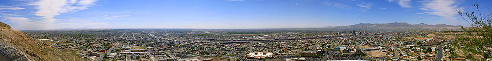

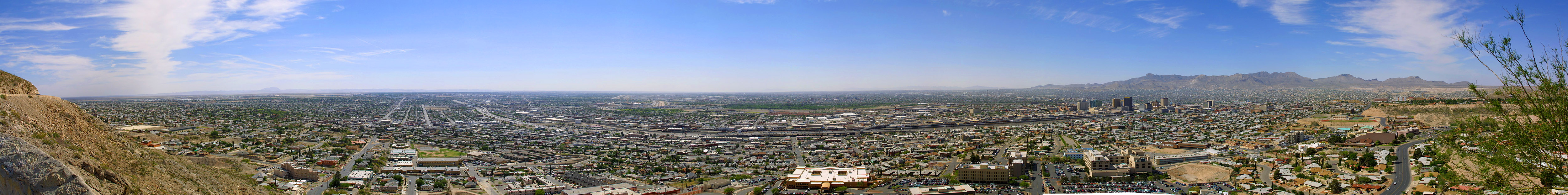
A panoramic view of El Paso, Texas from the north. The Hueco Mountains can be seen toward the east; the Juarez mountains of Mexico can be seen to the south (far right of the image).  El Paso (top) and Ciudad Juárez (bottom) as seen from earth orbit; the Rio Grande is the thin line separating the two cities through the middle of the photograph. A portion of the Franklin Mountains can be seen in the upper-left. Image courtesy of NASA.
 False color satellite image of El Paso and Ciudad Juárez. Paved streets and buildings appear in varying shades of blue-gray, and red indicates vegetation. Image courtesy of NASA.
El Paso is located at 31°47′25″N 106°25′24″W / 31.79028°N 106.42333°W (31.790208, -106.423242).[11] It lies at the intersection of three states (Texas, New Mexico, and Chihuahua) and two countries (the USA and Mexico). It is the only major Texas city on Mountain Time. Ciudad Juárez used to be on Central Time,[12] but both cities are now on Mountain Time.
The city's elevation is 3,800 feet (1,140 m) above sea level. North Franklin Mountain is the highest peak in the city at 7,192 feet (2,192 m) above sea level. The peak can be seen from 60 miles (100 km) in all directions. Additionally, this mountain range is home to the famous natural red-clay formation, the Thunderbird, from which the local Coronado High School gets its mascot's name. According to the United States Census Bureau, the city has a total area of 250.5 square miles (648.9 km²).
The 24,000-acre (9,700 ha) Franklin Mountains State Park is the largest urban park in the United States and resides entirely in El Paso, extending from the north and dividing the city into several sections along with Fort Bliss and El Paso International Airport.
The Rio Grande Rift, which passes around the southern end of the Franklin Mountains, is where the Rio Grande flows. The river defines the border between El Paso from Ciudad Juárez to the south and west until the river turns north of the border with Mexico, separating El Paso from Doña Ana County, New Mexico. Mt. Cristo Rey, a volcanic peak (an example of a pluton) rises within the Rio Grande Rift just to the west of El Paso on the New Mexico side of the Rio Grande. Other volcanic features include Kilbourne Hole and Hunt's Hole, which are Maar volcanic craters 30 miles (50 km) west of the Franklin Mountains.
El Paso is surrounded by the Chihuahuan Desert, the easternmost section of the Basin and Range Region.
Being in the westernmost tip of Texas, and due to the huge size of the state, El Paso is closer to four other state capitals (US and Mexican) than it is to its own capital of Austin, Texas (the other capitals being, Phoenix (Arizona), Santa Fe (New Mexico), neighboring Mexican city Chihuahua (Chihuahua), and Hermosillo (Sonora).[13][not in citation given][14][dead link]
Areas
- Central El Paso
- East El Paso
- Ysleta
- Far East El Paso-Montana Vista
- Mission Valley El Paso (Lower Valley and Ysleta, Texas)
- Northwest El Paso (Commonly known as West El Paso or Upper Valley)
- Northeast El Paso
- West Central El Paso
With the city limits are traditional suburban areas that are located on the far eastern and western edges.
Texas suburbs outside the city
- Anthony
- Canutillo
- Clint
- Fabens
- Homestead Meadows North
- Homestead Meadows South
- Horizon City
- Montana Vista
- San Elizario
- Socorro
- Sparks
- Vinton
- Tornillo
- Westway
New Mexico suburbs
Although New Mexican areas of Anthony, Sunland Park, and Chaparral lie adjacent to El Paso County, they are considered to be part of the Las Cruces, New Mexico metropolitan area by the United States Census Bureau.[15] Both metro areas do however, share a large commuter population, and also a media market.
Climate
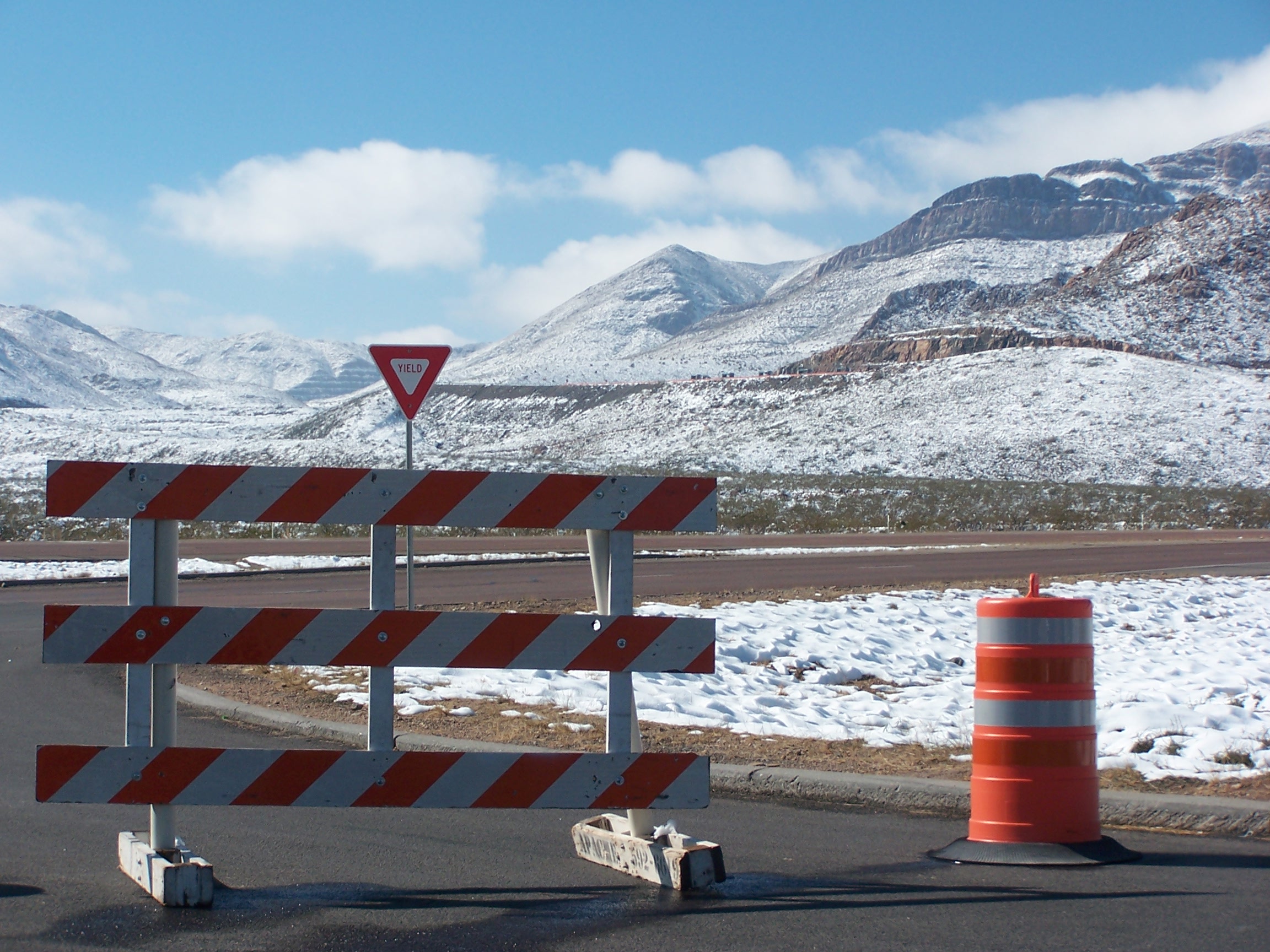
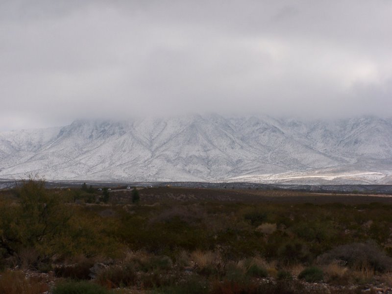
 Snow on Franklin Mountains & El Paso causes a closure of Woodrow Bean Transmountain Drive, which crosses the Franklins via Smuggler's Pass.
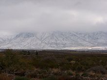 Snow on Franklin Mountains
El Paso has a hot desert climate (Koppen BWh) with very hot summers, usually with little or no humidity, and mild, dry winters. Rainfall averages 9.4 inches (240 mm) per year, much of which occurs during the summer from July through September and is predominantly caused by the monsoon. During this period, southerly and southeasterly winds carry moisture from the Pacific, the Gulf of California, and the Gulf of Mexico into the region. When this moisture moves into the El Paso area and places to the southwest, orographic lift from the mountains, combined with strong daytime heating, causes thunderstorms, some severe enough to produce flash flooding and hail, across the region.
The sun shines 302 days per year on average in El Paso, 83 percent of daylight hours, according to the El Paso Weather Bureau. It is from this that the city is nicknamed "The Sun City."[16] Due to its dry climate, El Paso often experiences wind and dust storms during the spring, usually starting in March and lasting to early May. With an average wind speed of up to 30 miles per hour (50 km/h)[citation needed] with gusts that have been measured at over 75 miles per hour (120 km/h),[citation needed] these wind storms kick up large amounts of sand causing loss of visibility.
El Paso, at 3,800 feet (1,200 m) elevation, is also capable of receiving snow; weather systems have produced over a foot of snow on several occasions. In 1980, three major snowstorms produced over a foot of snow; one in February, another in April and the last one in December, producing a white Christmas for the city.[citation needed] A major snowstorm in December 1987 dumped over two feet (65 cm) of snow.[17]
One example of El Paso's varying climate was the winter storm of early February 2011, which caused closures of schools, businesses, and City Hall. The snow stopped after about a day, but then because of below freezing temperatures El Paso utilities went into a crisis. Electric wires were broken, causing area blackouts; many water utility pipes froze, causing areas of the city to be without water for several days. When the pipes thawed, water was unsafe to drink due to filtration systems not working, therefore schools were closed again.[citation needed]
Monthly means range from 45.1 °F (7.3 °C) in January to 83.3 °F (28.5 °C) in July, but the warmest highs are typically in June. There are 60 nights below freezing, 109 days at or above 90 °F (32 °C) and 20 days above 100 °F (38 °C) each year.[17] The city's record high is 114 °F (46 °C), and its record low is −14 °F (−26 °C), with weather records for the area maintained by the National Weather Service since 1879.
Flooding
Although the average annual rainfall is only about 9 inches (225 mm), many parts of El Paso are subject to occasional flooding during intense summer monsoonal thunderstorms. In late July and early August 2006, over 15 inches (380 mm) of rain fell in a week, overflowing all the flood-control reservoirs and causing major flooding city-wide. The city staff has estimated damage to public infrastructure as $21 million, and to private property (residential & commercial) as $77 million.[18] Much of the damage was associated with development in recent decades in arroyos protected by flood-control dams and reservoirs, and the absence of any storm drain utility in the city to handle the flow of rain water.
Temperature statistics
Climate data for El Paso (El Paso Airport) Month Jan Feb Mar Apr May Jun Jul Aug Sep Oct Nov Dec Year Record high °F (°C) 80
(27)86
(30)93
(34)98
(37)105
(41)114
(46)112
(44)110
(43)104
(40)96
(36)87
(31)80
(27)114
(46)Average high °F (°C) 57.2
(14.0)63.4
(17.4)70.2
(21.2)78.1
(25.6)86.7
(30.4)95.3
(35.2)94.5
(34.7)92.0
(33.3)87.1
(30.6)77.9
(25.5)65.5
(18.6)57.4
(14.1)77.1 Average low °F (°C) 32.9
(0.5)37.5
(3.1)43.7
(6.5)51.1
(10.6)60.6
(15.9)68.8
(20.4)72.0
(22.2)70.2
(21.2)63.7
(17.6)51.8
(11.0)39.8
(4.3)33.4
(0.8)52.1 Record low °F (°C) −8
(−22.2)5
(−15)14
(−10)23
(−5)31
(−0.6)46
(8)56
(13)52
(11)41
(5)25
(−3.9)1
(−17.2)−5
(−20.6)−8
(−22.2)Precipitation inches (mm) .45
(11.4).39
(9.9).26
(6.6).23
(5.8).38
(9.7).87
(22.1)1.49
(37.8)1.75
(44.5)1.61
(40.9).81
(20.6).42
(10.7).77
(19.6)9.43
(239.5)Snowfall inches (cm) 1.5
(3.8).8
(2).3
(0.8).7
(1.8)0
(0)0
(0)0
(0)0
(0)0
(0).1
(0.3).9
(2.3)1.8
(4.6)6.1
(15.5)Avg. precipitation days (≥ 0.01 in) 4.7 3.1 2.2 1.7 2.8 3.5 8.2 8.8 6.5 4.9 3.1 4.3 53.8 Avg. snowy days (≥ 0.1 in) 1.2 .5 .1 .2 0 0 0 0 0 .1 .4 .7 3.2 Sunshine hours 254.2 265.6 325.5 348.0 384.4 384.0 359.6 334.8 303.0 297.6 258.0 244.9 3,759.6 Source no. 1: NOAA[17] Source no. 2: HKO[19] Cityscape
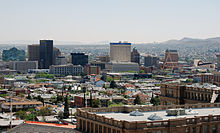 The El Paso skyline from the north
10 Tallest Buildings in El Paso
Rank Name Height Floors 1 Wells Fargo Plaza 296 feet (90 m) 21 2 Chase Tower 250 feet (76 m) 20 3 Plaza Hotel 239 feet (73 m) 19 4 Kayser Building 232 feet (71 m) 20 5 El Paso Natural Gas Company Building 208 feet (63 m) 18 6 Camino Real Hotel 205 feet (62 m) 17 7 Doubletree Hotel 202 feet (62 m) 17 8 O. T. Bassett Tower 196 feet (60 m) 15 9 El Paso County Courthouse 185 feet (56 m) 13 10 Anson Mills Building 145 feet (44 m) 12 El Paso's tallest building, the Wells Fargo Plaza, was built in the early-1970s as State National Plaza. The black-windowed, 296-foot (90 m) building is famous for its 13 white horizonal lights (18 lights per row on the east and west sides of the building, and 7 bulbs per row on the north and south sides) that were lit at night. The tower did use a design of the United States flag during the 4th of July holidays as well as the American hostage crisis of 1980, and was lit continuously following the September 11 attacks in 2001 until around 2006. During the Christmas holidays, a design of a Christmas tree was used, and at times, the letters "UTEP" was used to support University of Texas at El Paso athletics. The tower is now only lit during the holiday months, or when special events take place in the city.
Central Business Districts of Texas's ten largest cities (2010) Downtown Houston • Downtown Dallas • Downtown San Antonio • Downtown Austin • Downtown Fort Worth • Downtown El Paso • Downtown Arlington • Downtown Corpus Christi • Downtown Plano • Downtown LaredoDemographics
Historical populations Census Pop. %± 1890 10,000 — 1900 15,906 59.1% 1910 39,279 146.9% 1920 77,560 97.5% 1930 102,421 32.1% 1940 96,810 −5.5% 1950 130,003 34.3% 1960 276,687 112.8% 1970 339,615 22.7% 1980 425,259 25.2% 1990 515,342 21.2% 2000 563,662 9.4% 2010 649,121 15.2% [20] El Paso has historically been predominantly Hispanic. In the 1870s, a population of 23 Non-Hispanic whites and 150 Hispanics was reported.[21] In 1916, the Census Bureau reported El Paso's population as 53% Hispanic and 44% non-Hispanic white.[22]
According to the 2006–2008 American Community Survey, the racial composition of El Paso was as follows:
- White: 77.8% (Non-Hispanic Whites: 15.0%)
- Black or African American: 3.1%
- Native American: 0.5%
- Asian: 1.2%
- Native Hawaiian and Other Pacific Islander: 0.1%
- Some other race: 15.1%
- Two or more races: 2.2%
- Hispanic or Latino (of any race): 80.0% (Mexican: 75.0%)
Source:[23]
As of the census[2] of 2000, there were 563,662 people, 182,063 households, and 141,098 families residing in the city. The population density was 2,263.0 people per square mile (873.7/km²). There were 193,663 housing units at an average density of 777.5 per square mile (300.2/km²). The racial makeup of the city was 76.6% White, 3.12% African American, 0.82% Native American, 1.12% Asian, 0.10% Pacific Islander, 18.15% from other races, and 3.40% from two or more races. Hispanic or Latino of any race were 86.62% of the population.
There are 182,063 households, out of which 42.4% have children under the age of 18 living with them, 54.6% were married couples living together, 18.5% had a female householder with no husband present, and 22.5% were non-families. 19.2% of all households were made up of individuals and 7.2% had someone living alone who was 65 years of age or older. The average household size was 3.07 and the average family size was 3.54.
In the city the population was spread out with 31.0% under the age of 18, 10.0% from 18 to 24, 29.1% from 25 to 44, 19.2% from 45 to 64, and 10.7% who were 65 years of age or older. The median age was 31 years. For every 100 females there were 90.4 males. For every 100 females age 18 and over, there were 85.0 males.
The median income for a household in the city was $32,124, and the median income for a family was $35,432. Males had a median income of $28,989 versus $21,540 for females. The per capita income for the city was $14,388. About 19.0% of families and 22.2% of the population were below the poverty line, including 29.8% of those under age 18 and 17.7% of those age 65 or over.
According to the 2006 United States Census Bureau population estimates, the El Paso metropolitan area had a population of 736,310.[24] In 2010 CQ Press ranked El Paso safest city in the U.S. with a population over 500,000.[25]
In 2010, many Mexicans fleeing drug violence in Ciudad Juarez settled in El Paso. Benjamin Sáenz, a novelist and a literature professor at the University of Texas at El Paso, said during that year that El Paso was "becoming a lot more Mexican and a lot less Chicano."[26]
The Tigua Indians of Ysleta del Sur Pueblo
Located between the cities of El Paso and Socorro lies the sovereign Ysleta del Sur Pueblo Nation, with its own governing body.[27] It is one of the three Federally-recognized Indian tribes in Texas.[28]
The Tigua Indians have been at their present location since a successful Pueblo Revolt of 1680 that forced the Spaniards and New Spaniards (future Mexicans) to retreat south to present day Ciudad Juárez, Chihuahua and El Paso.[29] The tribe is led by a governor and a tribal council. Elections for tribal governor and tribal council are held once annually. As of January 2011, the governor is Frank Paiz.[30]
Government
Municipal
The city government is officially non-partisan; the county government is not. Mayors and City Council members may not serve for more than ten years in their respective offices.[31]
The current mayor of El Paso is John Cook, who defeated Mayor Joe Wardy in 2005 and was reelected in 2009.[32]
The current members of the El Paso City Council, who are elected every four years to staggered terms, are Emma Acosta (District 3), Susie Byrd (District 2), Steve Ortega (District 7), and Carl Robinson (District 4; Northeast), whose terms will end in 2013, and Eddie Holguin (District 6), Cortney Niland (District 8), Ann Lilly (District 1; Westside), and Dr. Mike Noe (District 5; Eastside), whose terms will end in 2015. Lilly, Byrd, Ortega, and Holguin, and have been on the council since 2005. Acosta has been on the council since 2008, Robinson since 2009, and Niland and Noe since 2011. Due to the term limits clause in the City Charter, several City Council members will not be eligible in the next election: Byrd, Holguin, Lilly, and Ortega, as well as Mayor Cook.[33][34]
According to city charter amendments approved on February 7, 2004, the city of El Paso operates under a council-manager form of government. This system combines the strong political leadership of elected officials, in the form of eight Council Members, with the strong managerial experience of an appointed local government manager. All power is concentrated in the elected council, which hires a professionally trained manager to carry out its directives and oversee the delivery of public services.[31] Joyce Wilson was selected by the city council in 2004 as El Paso's first City Manager.
El Paso County
The El Paso County Judge is Democrat Veronica Escobar, and the County Commissioners are as follows: Democrats Anna Perez (Precinct 1), Sergio Lewis (Precinct 2), Willie Gandara, Jr. (Precinct 3), and Republican Dan Haggerty (Precinct 4). Escobar and Lewis were first elected to their position in 2010, and have been in office since 2011.[35] Perez and Gandara were first elected to their positions in 2008, and have been in office since 2009. Haggerty was first elected to his position in 1994, and has been in office since 1995. The El Paso County Sheriff is Richard Wiles, Democrat, since 2009.
State
The Texas Department of Criminal Justice operates the El Paso I District Parole Office in the city. The El Paso II District Parole Office is in an unincorporated area east of Horizon City.[36]
Texas Legislature
El Paso City and County vote overwhelmingly Democratic, like most of the Texas–Mexico border area and urban Texas.[37] The El Paso metropolitan area is represented in the Texas State House by Democrats Marisa Marquez, Chente Quintanilla, Naomi Gonzalez, and Joe Pickett, and Republican Dee Margo; and in the State Senate by José R. Rodríguez (D-El Paso).[34] Quintanilla will not seek re-election in 2012.[38]
Federal
The El Paso metropolitan area is represented by Silvestre Reyes (D-El Paso), former chairman of the House Intelligence Committee, and Republican Quico Canseco (R-San Antonio) in the House of Representatives.[39] The current U.S. Senators for Texas are Kay Bailey Hutchison (R-Texas) and John Cornyn (R-Texas), however the El Paso area has heavily voted against them in Senatorial elections.
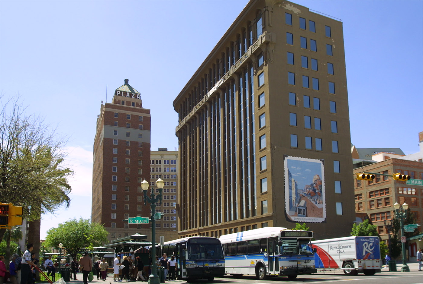
 Street scene in Downtown El Paso, San Jacinto plaza, the public square, once home to live alligators
Economy
El Paso is the Operational Headquarters of Helen of Troy Limited, a NASDAQ listed company that manufactures personal health care products under many labels such as OXO, Dr. Scholl's, Vidal Sassoon, Sunbeam, among others. Also headquartered in El Paso is Western Refining, listed on the New York Stock Exchange, and Spira Footwear,[citation needed] and Fred Loya Insurance, an insurance company.[40]
Until 1996, El Paso was home to El Paso Natural Gas Company. It is now in Houston, Texas under the name El Paso Corporation. Farah Clothing Company was also headquartered in El Paso until 1998 when Farah along with other clothing manufacturing companies such as Levi's, moved their plants in search of cheaper labor. In the 1980s El Paso was known as the blue jeans capital of the world because it produced over 2 million pairs of jeans every week from different jean companies in El Paso. As of 2006, the only remaining companies in the clothing industry are Wrangler and a smaller company by the name of Border Apparel.[citation needed]
More than 70 Fortune 500 companies have offices in El Paso, including The Hoover Company, Eureka, Boeing, and Delphi (auto parts).
El Paso is an important entry point to the U.S. from Mexico. Once a major copper refining area, chief manufacturing industries in El Paso now include food production, clothing, construction materials, electronic and medical equipment, and plastics. Cotton, fruit, vegetables, livestock, and pecans are produced in the area. With El Paso's attractive climate and natural beauty, tourism has become a booming industry as well as trade with neighboring Ciudad Juárez.
Education is also a driving force in El Paso's economy. El Paso's three large school districts are among the largest employers in the area, employing more than 19,000 people between them. The University of Texas at El Paso (UTEP) has an annual budget of nearly $250 million and employs nearly 3,600 people. A 2002 study by the university's Institute for Policy and Economic Development stated that the University's impact on local businesses has resulted in $349 million.
The military installation of Fort Bliss is a major contributor to El Paso's economy. Fort Bliss began as a Cavalry post in 1848. Today, Fort Bliss is the site of the United States Army's Air Defense Artillery Center and produces approximately $80 million in products and services annually, with about $60 million of those products and services purchased locally. Fort Bliss' total economic impact on the area has been estimated at more than $1 billion, with 12,000 soldiers currently stationed at the Fort. During the 2005 round of Base Realignment and Closure (BRAC), Fort Bliss came out an enormous winner. By 2013, BRAC growth is expected to add almost 28,000 new troops, 16,000 new spouses, and 21,000 new children to the El Paso community. The growth is expected to create a strong economic ripple throughout the El Paso area. With the growth in Fort Bliss, the economy is expected to profit an additional $10 billion by 2012, and an additional $5 billion each year after that.
In addition to the military, the federal government has a strong presence in El Paso to manage its status and unique issues as a border region. The Immigration and Customs Enforcement (ICE), the Drug Enforcement Administration (DEA), and the Customs and Border Protection Agency (CBP) all have agency operations in El Paso to regulate traffic and goods through ports of entry from Mexico. Including these agencies, government job growth in the area is expected to rise to 64,390 jobs by 2007. Many small businesses have been created with the growth of Fort Bliss. These companies support and provide many goods and services in areas as automotive, food and retail clothing. Another type of service provided by some companies are related directly to the Military itself such as Flags and Guidons, other areas that have flourished is the sewing and uniform companies
Call center operations make up 7 of the top 10 business employers in El Paso. With no signs of growth slowing in this industry, in 2005 the 14 largest call centers in El Paso employed more than 10,000 people. The largest of these in terms of employees are EchoStar, MCI[disambiguation needed
 ]/GC Services, and West Telemarketing.
Analysts in the area say that job growth in 2005 will be in the form of health care, business and trade services, international trade, and telecommunications.
Items and goods produced: petroleum, metals, medical devices, plastics, machinery, automotive parts, food, defense-related goods, tourism, boots
Largest city employers
- El Paso Independent School District 8,663
- Fort Bliss (civilian employees) 6,803
- Ysleta Independent School District 6,500
- City of El Paso 6,264
- University of Texas at El Paso 4,871
- Socorro Independent School District 3,995
- Sierra Providence Health Network 3,761
- El Paso Community College 3,728
- Wal-Mart 3,706
- El Paso County 2,700
- Las Palmas and Del Sol Regional Health Care System 2,244
- Echostar 2,012
All numbers are estimates as of 2006.[citation needed]
Sports
Major league teams
El Paso does not have any major league sports team. El Paso is the second largest city without a major sports team (Basketball, Baseball, Football, Hockey) in the continental United States. El Paso hosts the annual NCAA Hyundai Sun Bowl. El Paso is also the site of the Borderland Derby horse race held in the nearby suburb of Sunland Park.
Sports
Arenas
UTEP owns the two largest stadiums in El Paso:
- Sun Bowl Stadium has a capacity of 51,400 and is home to the UTEP Miners football team, coached by Mike Price. It is also home to the annual Sun Bowl, soccer games, and special events such as concerts.
- Don Haskins Center has a capacity of 12,222 and is used for UTEP's basketball teams and special events such as concerts and boxing matches. It is also where the graduation ceremony takes place for UTEP students.
Other arenas in El Paso include:
- Cohen Stadium has a capacity of 9,725 and is used primarily for the El Paso Diablos Independent baseball club. It also hosts concerts and boxing matches and is able to host soccer games as well.
- El Paso County Coliseum has a capacity of 5,250. It is currently used primarily for special events such as concerts, wrestling matches, and others. It can also be utilized for hockey and arena football.
- Memorial Gym is a 5,000 seat multi-purpose arena located on the UTEP campus. It was home to the Miners basketball teams until the Don Haskins Center, then known as the Special Events Center, opened in 1976.
- Patriot Stadium has a capacity of around 3,000 and is solely used for the Chivas El Paso Patriots soccer club.
Education
Public school districts
The city of El Paso is served by:
- Canutillo Independent School District
- El Paso Independent School District
- Socorro Independent School District
- Ysleta Independent School District
Nearby areas are served by:
- Anthony Independent School District
- Clint Independent School District
- Fabens Independent School District
- Gadsden Independent School District (in New Mexico)
- San Elizario Independent School District
- Tornillo Independent School District
Colleges and universities
Two-year and vocational colleges
- El Paso Community College
- International Business College
- Western Technical College
- Doña Ana Branch Community College with campuses in the El Paso Suburbs of Sunland Park and Anthony, New Mexico, with a new campus in Chaparral, New Mexico. This college is a part of the New Mexico State University system.
Four-year colleges & satellite campuses
- University of Texas at El Paso, or UTEP.
- Texas Tech University Health Sciences Center El Paso Campus
- Texas Tech College of Architecture at El Paso
- University of Phoenix-Santa Teresa, NM Campus
- Park University
- Webster University
Medical school
- Texas Tech University-Paul L. Foster School of Medicine
Private and parochial schools
There are several parochial schools within the Roman Catholic Diocese of El Paso:
- Primary schools:
- Father Yermo Primary School
- Loretto Academy Primary School
- Most Holy Trinity Catholic School
- Our Lady of the Assumption Catholic School
- Our Lady of the Valley Catholic School
- St. Joseph's Catholic School
- St. Matthew's Catholic School
- St. Patrick Cathedral School
- St. Pius X Catholic School
- St. Raphael Catholic School
- Secondary schools:
Other private schools include the following:
- Bethel Christian School
- Bridges Academy
- Covenant Christian Academy
- Community of Faith Christian School
- El Paso Adventist Junior Academy
- El Paso Country Day School
- El Paso Jewish Academy
- Faith Christian Academy
- Jesus Chapel School
- Immanuel Christian School
- Journey Academy
- Lydia Patterson Institute
- Mount Franklin Christian Academy
- Northeast Christian Academy
- North Loop Christian Academy
- Palm Tree Academy
- Radford School
- Rose of Sharon Academy
- St. Clement's Parish School
- Trinity Lutheran Church and School
Public libraries
El Paso Public Library operates public libraries in El Paso.
Hospitals
 University Medical Center
- Del Sol Medical Center[41]
- Las Palmas – Del Sol Rehab. Hospital
- Las Palmas Medical Center[42]
- Horizon Specialty Hospital
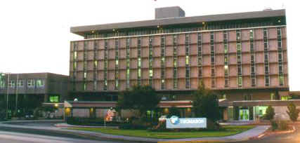
- University Medical Center- The city's general hospital and the only Level I trauma center in the area (Formerly Thomason Hospital)
- Rio Vista Rehab. Hospital
- Sierra Medical Center
- Southwestern General Hospital
- William Beaumont Army Medical Center
- Providence Memorial Hospital
- Physicians Hospital
- Highlands Regional Rehabilitation Hospital
- Sierra Providence East Medical Center
Culture
Literature

El Paso has been home to these figures such as:
- Alicia Gaspar de Alba
- Frank Ambriz
- José Antonio Burciaga
- Dagoberto Gilb
- Arturo Islas
- Tom Lea
- Cormac McCarthy
- Howard McCord
- Pat Mora
- John Rechy
- Benjamin Alire Saenz
- Eddie Guerrero
- Debbie Reynolds
Points of interest
Area museums
- The Centennial Museum and Chihuahuan Desert Gardens is located on the grounds of UTEP, including a comprehensive collection of El Paso Brown, Native American pottery, as well as educational exhibits for students.
 El Paso Museum of Archaeology, diorama shows Cueva de la Olla (cave of the pot - a large pot-shaped storage container for grain), Paquimé, Sierra Madre of Chihuahua
- The El Paso Museum of Archaeology is located on the eastern slope of North Franklin Mountain. Its grounds include native plants of the American Southwest as well samples of Native American shelters, in an unspoiled location. The museum includes dioramas for schoolchildren which illustrate the culture and geology of the American Southwest, such as Hueco Tanks in El Paso County. One diorama (see image to the right) is of the Cueva de la Olla[43] (cave of the pot) which is located in the Sierra Madre of Chihuahua, an example of the Paquimé culture.[44]
- The El Paso Museum of Art is located next to the Plaza Theater next to San Jacinto Plaza, the public square downtown. It contains works of southwestern artists such as Tom Lea.
- El Paso Museum of History
- Fort Bliss Museums & Study Center
- Insights El Paso Science Museum
- The Magoffin Homestead, dating from 1875, is now a State Historic Site.
- The National Border Patrol Museum is located adjacent to the El Paso Museum of Archaeology.
- Railroad & Transportation Museum of El Paso
- War Eagles Air Museum, Santa Teresa, New Mexico
- Gene Roddenberry Planetarium
- El Paso Holocaust Museum and Study Center
- Lynx Exhibits
Theaters
- The Abraham Chavez Theatre is located adjacent to the El Paso Convention & Performing Arts Center, welcomes patrons with a three-story-high glass-windowed entry and unique sombrero-shaped architecture making it a distinct feature on El Paso's southwestern landscape.
- The Plaza Theatre is a historic building located at 125 Pioneer Plaza in El Paso, Texas. The theater stands as one of the city's most well-known landmarks. It shows various Broadway productions, musical concerts, and individual performers. It has a seating capacity of 2,100.
- McKelligon Canyon is a 90-acre (360,000 m2) park, located in the Franklin Mountains, open to hikers and picnickers. In the canyon, McKelligon Canyon Amphitheatre is surrounded on three sides by dramatic canyon walls; the 1,500-seat amphitheatre is used for concerts and special events, such as Viva El Paso!
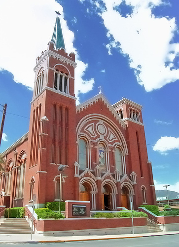
 The Cathedral Church of Saint Patrick is the mother church of the Diocese of El Paso.
Sites within the city limits
- Chamizal National Memorial
- El Paso Zoo
- Fort Bliss
- Franklin Mountains State Park
- Cathedral Church of Saint Patrick
- El Paso High School
- Magoffin Home State Historic Site
- Plaza Hotel
- Plaza Theatre
- Union Depot
- University of Texas at El Paso
- Wyler Aerial Tramway
- Ysleta Mission
Transportation
El Paso is served by El Paso International Airport, Amtrak via the historic Union Depot, Interstate 10, U.S. Highway 54 (known locally as "The Border Highway", "54", the "North-South Freeway" or officially as the Patriot Freeway), U.S. Highway 180 and U.S. Highway 62 (Montana Avenue), U.S. Highway 85 (Paisano Drive), Loop 375, Loop 478 (Copia Street-Pershing Drive-Dyer Street), numerous Texas Farm to Market Roads (a class of state highway commonly abbreviated to FM) and the city's original thoroughfare, State Highway 20, the eastern portion of which is known locally as Alameda Avenue (formerly U.S. Highway 80). Texas 20 also includes portions of Texas Avenue in Central El Paso, Mesa Street from Downtown to the West Side, and Doniphan Drive on the West Side. Northeast El Paso is connected to West El Paso by Transmountain Road. The city also shares 4 international bridges and one railbridge with Ciudad Juárez, Mexico. In 2009, El Paso was home to number 52, number 98 and number 100 of the 100 most congested roads in Texas, which are, respectively: North Zaragoza Road between Sun Fire Boulevard and Interstate 10; Lee Trevino Drive between Montana Avenue and Interstate 10; and Interstate 10 between Patriot Freeway and Loop 375.[45]
Airports
Passenger rail
- Amtrak, the national passenger rail system, serves El Paso at the historic Union Depot, operating its Sunset Limited three times weekly between New Orleans and Los Angeles.
Major highways
 Interstate 10 The primary thoroughfare through the city, connecting the city with other major U.S. cities such as Los Angeles, Phoenix, Houston, New Orleans, Gulfport,& Mobile, with the east end located in Jacksonville, Florida. I-10 is also a connector to Interstate 25, which connects with the cities of Albuquerque, Santa Fe, Colorado Springs, Denver, Fort Collins, Cheyenne, Casper, and north to the junction with I-90, located in Buffalo, Wyoming.
 U.S. Highway 54 Officially called the Patriot Freeway; also known as the North-South Freeway. A business route runs along Dyer Street, the former US 54, from the freeway near Fort Bliss to the Texas–New Mexico border, where it again rejoins the expressway. The original U.S. 54 was a transcontinental route connecting El Paso with Chicago.
 U.S. Highway 62 Santa Fe Street south of Paisano Drive concurrently with US 85, Paisano Drive east of Santa Fe Street to Montana Avenue, then Montana Avenue concurrently with US 180.
 U.S. Highway 85 Santa Fe Street south of Paisano Drive concurrently with US 62 and Paisano Drive west of Santa Fe Street to I-10.
 U.S. Highway 180 Montana Avenue, which is a bypass route to the Dallas-Fort Worth Metroplex to the east, and Flagstaff, Arizona to the west.
 SH 20 Alameda Avenue (formerly US 80), Texas Avenue, Mesa Street and Doniphan Drive.
 SH 178 Artcraft Road in Northwest El Paso extends from Interstate 10 west to the New Mexico state line, at which point it becomes New Mexico Highway 136, the Pete V. Domenici International Highway.
 Loop 375 Texas Highway Loop 375 encircles the city of El Paso. Between Interstate 10 and Fort Bliss, including the stretch that crosses the Franklin Mountains via Smuggler's Pass, it is TransMountain Road. In the Ft. Bliss Military Reservation in between Northeast and East El Paso, it is officially the Purple Heart Memorial Highway. In East El Paso, the north- and southbound section is known as Joe Battle Boulevard, or simply as "the Loop". South of I-10, in the east and westbound portion, it is known as the Cesar Chavez Border Highway, a four-lane expressway which is located along the U.S.-Mexico border between Downtown El Paso and the Ysleta area.
 Loop 478: Copia Street, Pershing Drive and Dyer Street.
 Spur 601. Once known as the Inner Loop, it was officially named the Liberty Expressway by the El Paso City Council in April 2010 at the request of Maj. Gen. Howard Bromberg, the commanding general of Fort Bliss.[46] It was fully completed on April 27, 2011;[47] it connects the Patriot Freeway (US 54) and Biggs Army Air Field to the Purple Heart Memorial Highway (Loop 375).
 North Loop Road, as well as Delta Drive between North Loop Road and Alameda Avenue (Texas Highway 20).
 Zaragoza Road, running more or less north from the Ysleta International Bridge to US 62-180 (Montana Avenue); it lies mostly in East El Paso.
 A portion of Clark Drive from Alameda Avenue (Texas Highway 20) north to Trowbridge Drive in South-Central El Paso.
 McRae Boulevard, running north from Interstate 10 to US 62-180 (Montana Avenue) in East El Paso.
 Texas Farm Road 2529 includes Stan Roberts Avenue and McCombs Street between Dyer Street and Stan Roberts Avenue in Northeast El Paso.
 Runs east from McCombs Street (Texas Farm Road 2529) in far Northeast El Paso; does not have a city street name.
 Texas Farm Road 3255 runs north from US 54 to the New Mexico state line in Northeast El Paso and bears the city street name Martin Luther King Boulevard.
Mass transit
The Sun Metro Mass Transit System operates a system of medium to large capacity natural gas powered buses all around the city of El Paso.[48]
El Paso County Transit makes trips with small capacity buses mainly in the Eastern El Paso area.
On September 1, 2009, NMDOT Park and Ride began operating commuter bus service to and from Las Cruces, New Mexico.[49]
Historically, El Paso and Ciudad Juarez had a shared streetcar system with a peak electrified route mileage of 64 miles (103 km) in 1920. The first electrified line across the Rio Grande which opened on January 11, 1902 was preceded by a network that relied on animal labor. The system quickly spread into residential and industrial areas of El Paso. In 1913 a 12 miles (19 km) interurban line was built to Ysleta. At the close of 1943 the holding company of El Paso Electric sold its subsidiary the El Paso Electric Railway Company and its Mexican counterpart to one of National City Lines' subsidiaries. This resulted in the formation of El Paso City Lines whose domestic streetcar lines were replaced by buses in 1947.[50] The international streetcar line which crossed the border via the Stanton Street Bridge continued to operate until 1973. In 1977 El Paso City Lines and two other bus companies were bought by the municipality and merged to form Sun City Area Transit (SCAT). In 1987 SCAT restyled itself Sun Metro.[51]
In 2011, Sun Metro has been named the most Outstanding Public Transit System of the Year in all of North America for a mid-size transit system by the American Public Transportation Association.
Walkability
A 2011 study by Walk Score ranked El Paso 44th most walkable of fifty largest U.S. cities.[52]
International border crossings
The first bridge to cross the Rio Grande at El Paso del Norte was built in the time of Nueva España, over 250 years ago, from wood hauled in from Santa Fe.[53] Today, this bridge is honored by the modern Santa Fe Street Bridge, and Santa Fe Street in downtown El Paso.
Several bridges serve the El Paso-Ciudad Juárez area. In addition to the Santa Fe Street Bridge, there is the Bridge of the Americas, Stanton Street Bridge, the Cordova Bridge, and the Zaragoza Bridge.
There is also a land crossing at nearby Santa Teresa, New Mexico, and the Fabens-Caseta International Bridge in nearby Fabens, Texas.
Media
Newspapers
The main newspapers are the English language daily El Paso Times, founded in 1881; and the Spanish language daily El Diario de El Paso. The now defunct El Paso Herald Post was also founded in 1881 as the El Paso Herald, which then merged with the El Paso Post in 1931. The paper was shut down in 1997.
Radio stations
Radio stations in the El Paso, Texas market By FM frequency KTEP 88.5 · KKLY 89.5 · KVER 91.1 · KOFX 92.3 · KSII 93.1 · KINT-FM 93.9 · KYSE 94.7 · KLAQ 95.5 · KHEY-FM 96.3 · KBNA-FM 97.5 · KTSM-FM 99.9 · KPRR 102.1 · KPAS 103.1By AM frequency NOAA Weather Radio frequency WXK25 (162.475) · WNG652 (162.550)Texas Radio Markets: Abilene · Amarillo · Austin · Beaumont–Port Arthur · Bryan–College Station · Corpus Christi · Dallas–Fort Worth · El Paso · Houston–Galveston · Killeen–Temple · Laredo · Lubbock · Lufkin–Nacogdoches · McAllen–Brownsville–Harlingen · Odessa–Midland · San Angelo · San Antonio · Tyler–Longview · Texarkana · Waco · Wichita FallsSee also: Ciudad Juarez RadioOther Texas Radio Regions: Bay City–Freeport · Big Spring–Snyder · Brownwood · Del Rio · Eagle Pass · Fort Stockton–Alpine · Kerrville–Fredericksburg · Kingsville–Alice–Falfurrias · Longview–Marshall · Paris · Sherman–Denison · Victoria
See also: List of radio stations in TexasRadio stations from Las Cruces, New Mexico and Ciudad Juárez, Chihuahua can also be heard within the El Paso market.
Television
El Paso was the largest city in the United States without a PBS television station within the city limits until 1978. El Paso viewers had to watch channel 22, KRWG from Las Cruces until 1978. In fact, the city had only three English-speaking channels and two Spanish language channels (channel 2 and channel 5) from Juarez, and cable TV subscribers in the 1970s and 1980s could receive four Los Angeles independent channels: KTLA, KHJ, KTTV and KCOP. Over time, as more television stations signed on and more cable channels were added (and the internet expanded), the L.A. stations would disappear from the lineup. The last to be removed was KTLA in the Fall of 2006, when KVIA-TV opened its own CW station.
El Paso's current television stations are as shown in the table below:
Local stations KDBC (4.1 CBS, 4.2 MNTV) • KVIA (7.1 ABC, 7.2 CW, 7.3 StormTRACK 24/7, 7.4 KAEP-LP/AZA) • KTSM (9.1 NBC, 9.2 Estrella TV) • KCOS (13.1 PBS), • KFOX (14.1 Fox, 14.2 RTV) • KINT (26.1 UNI, 26.2 TFU, 26.3 LATV) • KSCE (38.1 Religious Ind, 38.2 Spanish releigious Ind, 38.3 Scriptures) • K26KJ (40.1 Multimedios) • KTFN (65.1 TFU HD, 65.2 TFU SD, 65.3 LATV)
Las Cruces Ciudad Juárez Texas Broadcast television areas by city: Abilene/Sweetwater • Amarillo (Texas Panhandle) • Austin • Beaumont/Port Arthur • Corpus Christi • Dallas-Fort Worth • Del Rio • Eagle Pass • El Paso • Houston • Laredo • Lubbock • Midland-Odessa (Permian Basin) • Rio Grande Valley • San Angelo • San Antonio • Sherman/Ada, OK • Texarkana/Shreveport, LA • Tyler/Longview (East Texas) • Victoria • Waco/Bryan (Brazos Valley) • Wichita Falls/Lawton, OK
New Mexico Broadcast television areas by city: Albuquerque/Santa Fe • Amarillo, TX • El Paso, TX • Odessa/Midland, TX
Chihuahua Broadcast television areas by city: Balleza • Camargo • Cuauhtemoc • Chihuahua City • Ciudad Juárez • Delicias • Ciudad Madera • Hidalgo del Parral • Jimenez • Nuevo Casas Grandes • Ocampo • Ojinaga • Riva Palacio • San Buenaventura •
Santa BarbaraCellular phone coverage
KTSM TV reports[54] that cellular phone users in El Paso are subject to International Calling fees (unless they disable roaming with their cellular phone providers).
Popular culture
See also: List of people from El Paso, Texas- "El Paso" by Marty Robbins was a popular Country ballad released in 1959. Robbins followed it up with a sequel, "El Paso City," in 1976.
- Fleetwood Mac held their first concert that featured Stevie Nicks and Lindsey Buckingham in El Paso in 1975. Stevie Nicks attended Loretto Academy and Bassett Junior High in El Paso as a teenager.
- "Take The Money and Run"- a hit song by the Steve Miller Band- tells the story of two bandits who "go down to old El Paso" and "get into a great big hassle."
- The current Blue Beetle comic book series takes place in El Paso.
- El Paso has become a favored destination for musicians of all stripes. See Vanity Fair's March 2009 article.
- In Ghost Recon Advanced Warfighter 2, the penultimate mission is set in El Paso.
- The Chinga Chavin song "Asshole From El Paso" (most famously recorded by Kinky Friedman), a parody of Merle Haggard's "Okie from Muskogee", mentions El Paso in both the lyrics and the title.
- American artist Tori Amos references El Paso in her song, "Mother Revolution," featured on 2005's The Beekeeper.
- In the film 'For a Few Dollars More', a bank in El Paso is robbed.
- In the second season of "Breaking Bad", DEA Agent Hank Schrader is transferred from his office in Albuquerque to the headquarters in El Paso.
Filmed in El Paso
- The Burning Plain (2009) starring Charlize Theron. One scene was shot on 2nd floor at Southwest General Hospital.
- Stephen Fry In America (2008) documentary
- The Last Conquistador (2008), a PBS POV documentary about the Oñate statue controversy
- Glory Road (2006) starring Josh Lucas is set in El Paso.
- Man on Fire (2004) starring Denzel Washington and Dakota Fanning.
- The Day After Tomorrow (2004) starring Dennis Quaid and Sela Ward.
- Saving Jessica Lynch (2003) starring Laura Regan.
- Kingpin (NBC pilot) (2003) starring Yancey Arias and Brian Benben.
- The Original Latin Kings of Comedy (2002) featuring George Lopez, Cheech Marin, Joey Medina, Alex Reymundo and Paul Rodriguez was shot at the Abraham Chavez Theater.
- Traffic (2000) starring Benicio del Toro, Michael Douglas, Catherine Zeta-Jones, Dennis Quaid and Don Cheadle.
- Committed (2000) starring Heather Graham.
- On the Border (1998) starring Casper Van Dien, Bryan Brown, Daniel Baldwin.
- Lolita (1997) starring Jeremy Irons and Melanie Griffith.
- Last Man Standing (1996) starring Bruce Willis, Bruce Dern, Christopher Walken, Karina Lombard.
- Blue Sky (1994) starring Jessica Lange and Tommy Lee Jones.
- Wild at Heart (1990) starring Nicolas Cage and Laura Dern.
- Extreme Prejudice (1987) starring Nick Nolte and Powers Boothe.
- Lost in America (1985) starring Albert Brooks and Julie Hagerty.
- Paris, Texas (1984) starring Harry Dean Stanton and Dean Stockwell.
- Lone Wolf McQuade (1983) starring Chuck Norris and David Carradine.
- Wrong is Right (1982) starring Sean Connery.
- The Border (1982) starring Jack Nicholson and Harvey Keitel. All the border scenes, the refugee camp scene, and the U.S. Embassy scene were shot in and around El Paso.
- Resurrection (1980) starring Ellen Burstyn.
- When You Comin' Back, Red Ryder? (1979) starring Hal Linden and Lee Grant.
- Big Wednesday (1978) starring Jan Michael Vincent and Gary Busey.
- I Thought It Was A Go (2007) starring Kaelo Makua James and Chris "Nyph" Ashness. A Deathcore music video featuring the Deathcore band The Odessa Trail.
- The Bad News Bears in Breaking Training (1977) starring William Devane.
- The Getaway (1972) starring Steve McQueen and Ali MacGraw.
- Manos: The Hands of Fate (1966), which is reputed to be one of the worst films ever made, was shot in and around El Paso. It premiered in 1966 at the downtown Capri Theater.
- Take the High Ground! (1953), starring Richard Widmark and Karl Malden.
Sister cities
El Paso, Texas has the following sister cities:
 – Chihuahua, México[55]
 – Jerez de la Frontera, Spain[56]
- – Mérida, Spain[56]
- – Juárez, México[56]
- – Torreón, México[56]
- – Zacatecas, México[56]
See also
- List of people from El Paso, Texas
- National Register of Historic Places listings in El Paso County, Texas
Notes
- ^ a b c http://factfinder2.census.gov
- ^ a b "American FactFinder". United States Census Bureau. http://factfinder.census.gov. Retrieved 2008-01-31.
- ^ "US Board on Geographic Names". United States Geological Survey. 2007-10-25. http://geonames.usgs.gov. Retrieved 2008-01-31.
- ^ The evidence points to 10,000 to 12,000 years of human habitation.
- ^ Leon C. Metz (1993). El Paso Chronicles: A Record of Historical Events in El Paso, Texas. El Paso: Mangan Press. ISBN 0-930208-32-3.
- ^ Mark Sumner (2011-01-30). "America, the artifact". http://www.dailykos.com/storyonly/2011/1/30/939933/-America,-the-artifact.
- ^ a b El Paso, A Borderlands History, by W.H. Timmons, pp. 74, 75
- ^ a b c El Paso, Texas from the Handbook of Texas Online
- ^ '''Records of California men in the war of the rebellion 1861 to 1867''', By California. Adjutant General's Office, SACRAMENTO: State Office, J. D. Young, Supt. State Printing. 1890. p.672. Books.google.com. http://books.google.com/books?pg=RA2-PA672&id=RTEOAAAAIAAJ#v=onepage&q=&f=false. Retrieved 2010-07-01.
- ^ Víctor M. Macías-González (1995). Mexicans "of the better class": The elite culture and ideology of Porfirian Chihuahua and its influence on the Mexican American generation, 1876-1936. El Paso: UTEP.
- ^ "US Gazetteer files: 2010, 2000, and 1990". United States Census Bureau. 2011-02-12. http://www.census.gov/geo/www/gazetteer/gazette.html. Retrieved 2011-04-23.
- ^ "Time changes in Chihuahua". Timeanddate.com. http://www.timeanddate.com/worldclock/timezone.html?n=65&syear=1990. Retrieved 2010-07-01.
- ^ http://www.guestlife.com/media/GuestLife/El-Paso/The-411-On-El-Paso/The-411-Fascinating-Facts/
- ^ http://epdreamhomes.com/EL_PASO.html
- ^ http://www.census.gov/population/estimates/metro-city/List4.txt
- ^ Carlos A. Rincón (2002). "Solving Transboundary Air Quality Problems in the Paso Del Norte Region". In Linda Fernandez and Richard Carson. Both Sides of the Border. Springer. ISBN 1402071264. http://books.google.com/books?id=-80qhQ3mLDQC&pg=PA259&dq=%22el+paso%22+%22the+sun+city%22&as_brr=3&ei=tN4ySdq9GYbWlQS895i3DQ.
- ^ a b c "Climatography of the United States No. 20: El Paso Intl AP, TX 1971–2000" (PDF). National Oceanic and Atmospheric Administration. http://cdo.ncdc.noaa.gov/climatenormals/clim20/tx/412797.pdf. Retrieved 2010-04-27.
- ^ "City of El Paso". www.elpasotexas.gov. http://www.elpasotexas.gov/community/. Retrieved 2010-07-01.
- ^ "Climatological Normals of El Paso". Hong Kong Observatory. June 2011. http://www.hko.gov.hk/wxinfo/climat/world/eng/n_america/us/el_paso_e.htm. Retrieved 2010-05-13.
- ^ http://www.elpasotexas.gov/_documents/demographics/El%20Paso%20Ciudad%20Juarez%20Facts/Historical%20Population%20El%20Paso-Ciudad%20Juarez.pdf
- ^ "elpasonext - DOWNTOWN EL PASO HISTORY". Elpasotexas.gov. http://www.elpasotexas.gov/downtown/history.htm#1_6. Retrieved 2010-07-01.
- ^ Special census of the population of ... - Google Books. Books.google.com. 1916-01-15. http://books.google.com/books?id=hF3JAAAAMAAJ&lpg=PA3&ots=XC8gFx8On2&pg=PA4#v=onepage&q&f=false. Retrieved 2010-07-01.
- ^ American FactFinder, United States Census Bureau. "El Paso city, Texas - ACS Demographic and Housing Estimates: 2006–2008". Factfinder.census.gov. http://factfinder.census.gov/servlet/ADPTable?_bm=y&-geo_id=16000US4824000&-qr_name=ACS_2008_3YR_G00_DP3YR5&-ds_name=ACS_2008_3YR_G00_&-_lang=en&-redoLog=false&-_sse=on. Retrieved 2010-07-01.
- ^ [1][dead link]
- ^ http://www.elpasotimes.com/news/ci_16675219
- ^ Corchado, Alfredo. "Families, businesses flee Juárez for U.S. pastures." The Dallas Morning News. Sunday March 7, 2010. Retrieved on March 10, 2010.
- ^ Ysleta del Sur Pueblo official site
- ^ Texas -- American Indian Area
- ^ Pueblo Revolt Brought Tiguas South
- ^ Tiguas select new chief, re-elect governor
- ^ a b http://www.elpasotexas.gov/muni_clerk/_documents/2004_Charter_Election_Resolution.pdf
- ^ "It's John Cook in a landslide: El Pasoans 'proud of the work' city has done". El Paso Times. http://www.elpasotimes.com/ci_12336439. Retrieved 2010-07-01.
- ^ "City of El Paso". www.elpasotexas.gov. 2004-02-07. http://www.elpasotexas.gov/government.asp. Retrieved 2010-07-01.
- ^ a b http://www.epcounty.com/elections/current/final.htm
- ^ http://www.elpasotimes.com/newupdated/ci_16986781
- ^ "Parole Division Region V." Texas Department of Criminal Justice. Retrieved on May 22, 2010.
- ^ William Earl Maxwell, Ernest Crain, Edwin S. Davis (2005). Texas Politics Today. Thomson Wadsworth. ISBN 0534602118.
- ^ http://www.elpasotimes.com/news/ci_19051647
- ^ http://www.texastribune.org/texas-representatives-in-congress/us-congress/cook-cd-17-not-competitive-in-2012/
- ^ "Contact Us." (Archive) Fred Loya Insurance. Retrieved on August 9, 2010. "Corporate Headquarters 1800 Lee Trevino El Paso, Texas 79936."
- ^ http://www.delsolmedicalcenter.com/
- ^ "Las Palmas Medical Center - Home Page". Laspalmashealth.com. 2009-08-07. http://www.laspalmashealth.com/. Retrieved 2010-07-01.
- ^ John Noble, Mexico p. 365
- ^ Cultura Paquime: Sitios Arqueologicos - Paquime Culture Documental Documentary see minute 0:32 of 4:18 total
- ^ "Texas' Most Congested Roads". www.texastribune.org. http://www.texastribune.org/library/data/texas-road-congestion/. Retrieved 2010-10-04.
- ^ "Fort Bliss welcomes change from Spur 601". El Paso Times. http://www.elpasotimes.com/ci_14894650. Retrieved 2010-07-01.
- ^ "El Paso's Spur 601 Expressway Now Fully Operational - News Story - KVIA El Paso". KVIA.com. 2011-04-27. http://www.kvia.com/news/27694876/detail.html. Retrieved 2011-07-25.
- ^ "Sun Metro Homepage". www.elpasotexas.gov. http://www.elpasotexas.gov/sunmetro/. Retrieved 2010-07-01.
- ^ "History and Facts". NMDOT. http://nmshtd.state.nm.us/main.asp?secid=15736. Retrieved 22 November 2009.
- ^ Myrick, David F. (1970). New Mexico's Railroads: An Historical Survey. Golden: Colorado Railroad Museum. pp. 189–190.
- ^ "El Paso Mass Transit History". City of El Paso. http://www.elpasotexas.gov/sunmetro/sunhis.asp. Retrieved 22 November 2009.
- ^ "2011 City and Neighborhood Rankings". Walk Score. 2011. http://www.walkscore.com/rankings/cities/. Retrieved Aug 28, 2011.
- ^ Paul Horgan, Great River: The Rio Grande in North American History. Volume 1, Indians and Spain. Vol. 2, Mexico and the United States. 2 Vols. in 1, 1038 pages - Wesleyan University Press 1991, 4th Reprint, ISBN 0-8195-6251-3
- ^ KTSM TV (Channel 9) news broadcast, El Paso, Texas, Friday July 30, 2010
- ^ "City Council Meetings - Voting Items". City of El Paso. 2008-11-18. http://www.elpasotexas.gov/muni_clerk/vitem_select_results.asp?item=10870. Retrieved 27 December 2008. "ADDN1A. MAYOR AND COUNCIL: Discussion and action to authorize the Mayor to sign a Sister City agreement with the City of Chihuahua, México reaffirming the commitment made in 2002. ACTION TAKEN: AUTHORIZED"
- ^ a b c d e Andrade, Robert (March 2007). "Sister Cities". ¿Qué Pasa? A biweekly electronic newsletter from Mayor Cook. City of El Paso. http://www.elpasotexas.gov/mayor/newsletter_march07.asp. Retrieved 27 December 2008. "Currently on record, there are four Sister Cities, three in México (Ciudad Juárez, Zacatecas and Torreón) and one in Spain (Jerez)."
External links
- City of El Paso Website
- Chamber of Commerce Website
- Forty years at El Paso, 1858–1898; recollections of war, politics, adventure, events, narratives, sketches, etc., by W. W. Mills, hosted by the Portal to Texas History
- El Paso Metropolitan Planning Organization
- El Paso, Texas from the Handbook of Texas Online
- El Paso - The Best Little Music City in Texas, from Vanity Fair, March 2009.
Municipalities and communities of El Paso County, Texas County seat: El PasoCities El Paso | Horizon City | Socorro
Towns Village CDPs Unincorporated
communities50 most populous cities of the United States (2010 United States Census Bureau)Mayors of cities with populations exceeding 100,000 in Texas - Annise Parker (Houston)
- Julian Castro (San Antonio)
- Mike Rawlings (Dallas)
- Lee Leffingwell (Austin)
- Betsy Price (Fort Worth)
- John Cook (El Paso)
- Robert Cluck (Arlington)
- Joe Adame (Corpus Christi)
- Phil Dyer (Plano)
- Raul Gonzalez Salinas (Laredo)
- Tom Martin (Lubbock)
- Ronald E. Jones (Garland)
- Beth Van Duyne (Irving)
- Debra McCartt (Amarillo)
- Tony Martinez (Brownsville)
- Charles England (Grand Prairie)
- Johnny Isbell (Pasadena)
- John Monaco (Mesquite)
- Richard F. Cortez (McAllen)
- Ron Branson (Carrollton)
- Virginia DuPuy (Waco)
- Bill Whitfield (McKinney)
- Mark Burroughs (Denton)
- Timothy L. Hancock (Killeen)
- Norm Archibald (Abilene)
- Becky Ames (Beaumont)
- Wes Perry (Midland)
- Alan McGraw (Round Rock)
- Dean Ueckert (Lewisville)
- Bill Keffler (Richardson)
- Lanham Lyne (Wichita Falls)
- Larry Melton (Odessa)
 Other states: AL • AK • AZ • AR • CA • CO • CT • DE • FL • GA • HI • ID • IL • IN • IA • KS • KY • LA • ME • MD • MA • MI • MN • MS • MO • MT • NE • NV • NH • NJ • NM • NY • NC • ND • OH • OK • OR • PA • RI • SC • SD • TN • TX • UT • VT • VA • WA • WV • WI • WYCategories:
- El Paso, Texas
- Cities in Texas
- County seats in Texas
- Populated places in El Paso County, Texas
- Populated places in Texas with Hispanic majority populations
- Populated places established in 1659
- Mexico–United States border towns
- Butterfield Overland Mail


Wikimedia Foundation. 2010.