- Crowell, Texas
-
Crowell, Texas — City — Location of Crowell, Texas

Coordinates: 33°59′9″N 99°43′28″W / 33.98583°N 99.72444°WCoordinates: 33°59′9″N 99°43′28″W / 33.98583°N 99.72444°W Country United States State Texas County Foard Area - Total 1.9 sq mi (4.9 km2) - Land 1.9 sq mi (4.9 km2) - Water 0.0 sq mi (0.0 km2) Elevation 1,473 ft (449 m) Population (2000) - Total 1,141 - Density 604.6/sq mi (233.4/km2) Time zone Central (CST) (UTC-6) - Summer (DST) CDT (UTC-5) ZIP code 79227 Area code(s) 940 FIPS code 48-17948[1] GNIS feature ID 1355438[2] Crowell is a city in Foard County, Texas, United States. It serves as the county seat[3], and the population was 1,141 at the 2000 census.
Contents
Geography
Crowell is located at 33°59′9″N 99°43′28″W / 33.98583°N 99.72444°W (33.985838, -99.724430).[4]
According to the United States Census Bureau, the city has a total area of 1.9 square miles (4.9 km2), all of it land.
Elevation is approximately 1,300 ft (400 m) above sea level. The terrain is varied, but mostly level with rolling hills. Soil varies from slightly sandy loam to mostly sandy. Soil and meteorological conditions make the area suitable for growing wheat, cotton, and hay crops (alfalfa and cane). Little of the area immediately around Crowell has underground water in amounts suitable for irrigation. The majority of the area immediately east of Crowell is dedicated to cultivated crops. The majority of the area immediately west of Crowell is dedicated to raising beef cattle.
Demographics
As of the census[1] of 2000, there were 1,141 people, 465 households, and 292 families residing in the city. The population density was 604.6 people per square mile (233.1/km²). There were 568 housing units at an average density of 301.0 per square mile (116.0/km²). The racial makeup of the city was 83.26% White, 3.07% African American, 0.70% Native American, 11.13% from other races, and 1.84% from two or more races. Hispanic or Latino of any race were 17.62% of the population.
There were 465 households out of which 29.7% had children under the age of 18 living with them, 50.3% were married couples living together, 10.3% had a female householder with no husband present, and 37.0% were non-families. 34.4% of all households were made up of individuals and 21.7% had someone living alone who was 65 years of age or older. The average household size was 2.36 and the average family size was 3.08.
In the city the population was spread out with 26.8% under the age of 18, 5.9% from 18 to 24, 21.9% from 25 to 44, 22.3% from 45 to 64, and 23.0% who were 65 years of age or older. The median age was 40 years. For every 100 females there were 82.9 males. For every 100 females age 18 and over, there were 79.6 males.
The median income for a household in the city was $22,214, and the median income for a family was $30,667. Males had a median income of $21,141 versus $16,184 for females. The per capita income for the city was $12,965. About 11.4% of families and 16.4% of the population were below the poverty line, including 17.1% of those under age 18 and 19.6% of those age 65 or over.
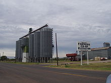 Historic Cooperative Elevator, Crowell, TX
=P
History
Located between the Pease and North Wichita river , the area has long been home to a variety of hardy animal and plant species. Native grasses tend to be hardy and drought-tolerant. Tree varieties include bush cedar, mesquite, hackberry, mulberry, and pecan, in addition to several imports that thrive in the warm, semi-arid conditions. Native animals species include coyote, squirrels, badgers, raccoons, and the occasional fox. Deer have also become plentiful in recent decades, as have feral pigs. Bird species include quail, dove, and several types of migratory waterfowl. Crowell is on the migration path of the monarch butterfly.
Crowell is only a few miles from the re-capture location of Cynthia Ann Parker. Known locally as the 'Pease River battleground', Cynthia Ann, captured as a child by raiding Indians, was recaptured here as an adult by U.S. soldiers. Cynthia Ann was the mother of Quanah Parker, considered the last great Chief of the Comanche.
Though few notables and celebrities call Crowell home there remain some worth mention. Former football star Dick Todd set long-standing records as a running back for Texas A&M University. He then went on to play for, and eventually coach, the Washington Redskins. Todd's son, Denny, died as a teenager from injuries sustained on the football field. His memory is honored each year with an award in his name. The award is presented to the football team member who shows the greatest personal contribution to the team, both on and off the field.
The remote, rural location minimizes light pollution, making for an excellent view of the night sky. As a result Crowell is also home to Comanche Springs Astronomy Campus, a 50-acre (200,000 m2) observatory built by Three Rivers Foundation for the Arts & Sciences. The economy is almost solely agrarian. Beef cattle, wheat, and cotton are the primary sources of income and employment. Hunting leases are quickly becoming a notable contributor to the local economy. The single manufacturing industry is a cap factory. Formerly owned by the DeLong company, the factory is now owned by a group of local investors.
Though a small, rural community, Crowell still has stop-worthy interests. In addition to the observatory, there is an amazingly nice museum built by the Foard County Historical Society. Housed in the former fire house, the museum boasts interesting artifacts from the history of Crowell and environs. Most notable is the one-of-a-kind scale town. Designed to reflect the historically notable businesses in city history, the diorama-style exhibits are an interesting change from 'regular' museums. Just across the street from the Firehall Museum is the Farm Implement museum which is, if nothing else, interesting in its sheer variety.
In 2009, the Zion Lutheran Cemetery was named an historic Texas cemetery by the Texas Historical Commission. The cemetery is located just west of the Zion Lutheran Church near the intersection of FM 2073 and FM 2074 several miles off U.S. Highway 70 between Lockett and Crowell.[5]
Education
The City of Crowell is served by the Crowell Independent School District.
References
- ^ a b "American FactFinder". United States Census Bureau. http://factfinder.census.gov. Retrieved 2008-01-31.
- ^ "US Board on Geographic Names". United States Geological Survey. 2007-10-25. http://geonames.usgs.gov. Retrieved 2008-01-31.
- ^ "Find a County". National Association of Counties. http://www.naco.org/Counties/Pages/FindACounty.aspx. Retrieved 2011-06-07.
- ^ "US Gazetteer files: 2010, 2000, and 1990". United States Census Bureau. 2011-02-12. http://www.census.gov/geo/www/gazetteer/gazette.html. Retrieved 2011-04-23.
- ^ Wichita Falls Times Record News, September 28, 2009
External links
Municipalities and communities of Foard County, Texas County seat: CrowellCity Crowell

Unincorporated
communityCounty seats of Texas A B Baird · Ballinger · Bandera · Bastrop · Bay City · Beaumont · Beeville · Bellville · Belton · Benjamin · Big Lake · Big Spring · Boerne · Bonham · Boston · Brackettville · Brady · Breckenridge · Brenham · Brownfield · Brownsville · Brownwood · Bryan · BurnetC Caldwell · Cameron · Canadian · Canton · Canyon · Carrizo Springs · Carthage · Center · Centerville · Channing · Childress · Clarendon · Clarksville · Claude · Cleburne · Coldspring · Coleman · Colorado City · Columbus · Comanche · Conroe · Cooper · Corpus Christi · Corsicana · Cotulla · Crane · Crockett · Crosbyton · Crowell · Crystal City · CueroD E F Fairfield · Falfurrias · Farwell · Floresville · Floydada · Fort Davis · Fort Stockton · Fort Worth · Franklin · FredericksburgG Gail · Gainesville · Galveston · Garden City · Gatesville · George West · Georgetown · Giddings · Gilmer · Glen Rose · Goldthwaite · Goliad · Gonzales · Graham · Granbury · Greenville · Groesbeck · Groveton · GuthrieH Hallettsville · Hamilton · Haskell · Hebbronville · Hemphill · Hempstead · Henderson · Henrietta · Hereford · Hillsboro · Hondo · Houston · HuntsvilleJ K L M N O P Paducah · Paint Rock · Palestine · Palo Pinto · Panhandle · Paris · Pearsall · Pecos · Perryton · Pittsburg · Plains · Plainview · Port Lavaca · PostQ R Rankin · Raymondville · Refugio · Richmond · Rio Grande City · Robert Lee · Roby · Rockport · Rocksprings · Rockwall · RuskS San Angelo · San Antonio · San Augustine · San Diego · San Marcos · San Saba · Sanderson · Sarita · Seguin · Seminole · Seymour · Sherman · Sierra Blanca · Silverton · Sinton · Snyder · Sonora · Spearman · Stanton · Stephenville · Sterling City · Stinnett · Stratford · Sulphur Springs · SweetwaterT, U V, W, Z Van Horn · Vega · Vernon · Victoria · Waco · Waxahachie · Weatherford · Wellington · Wharton · Wheeler · Wichita Falls · Woodville · ZapataCategories:- Cities in Texas
- Populated places in Foard County, Texas
- County seats in Texas


Wikimedia Foundation. 2010.