- Mischief Reef
-
Part of a series on the Spratly Islands 
Spratly Islands
Spratly Islands dispute
Philippines and the Spratly Islands
Republic of Morac-Songhrati-Meads
Territorial disputes in the South China SeaConfrontations Islands by occupation Occupied by MalaysiaOccupied by China (PRC)- Johnson South Reef · Chigua Reef
- Mischief Reef · Meiji Reef
- Subi Reef · Zhubi Reef
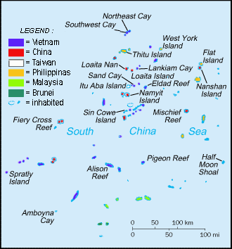
Occupied by the PhilippinesOccupied by Taiwan (RoC)Mischief Reef or Meiji Reef (Chinese: 美济礁; pinyin: Meiji Jiao; Tagalog: Panganiban; Vietnamese: Đá Vành Khăn) is a reef in the Spratly Islands in South China Sea. Some rocks above water at low tide. It has a lagoon.[1] The reef is controlled by the People's Republic of China, and claimed by the Republic of China (Taiwan) as well as the Philippines and Vietnam.
Chinese Occupation
The Philippines once largely controlled this feature. Filipino fishermen used to fish at the reef.[2][3][4] In 1994, the PRC built initial structures on stilts here while the Philippine Navy was not patrolling the area due to a monsoon season. Since the reef is just 130 miles (209 km) away from Palawan, well inside the Philippines' EEZ, the Philippines immediately protested this action. However, China rejected the protest and stressed that the structures were shelter for fishermen. In 1999, another wave of protests from Manila occurred when China added more structures to Mischief Reef which resembled military installations more closely than shelters for fishermen.[4]
The Philippines dubbed China's actions in South China Sea part of China's "creeping invasion." For instance, China is also reported to have planted buoys in Sabina Shoal, a much closer reef from Palawan which is just 70 miles (113 km) away. Philippines claimed that China had a well-rehearsed routine when laying claim to a new reef: first put down buoys, then build concrete markers. Temporary wooden or bamboo shelters followed, and if China was still not challenged, the permanent military forts went up. The Philippines tries to destroy the buoys or markers before China has time to build larger structures.[4]
The Philippines' decision not to destroy the Chinese structures on Mischief Reef prevented an escalation of the dispute. The Philippines claims that China has always been prepared for armed conflict when opposed, as is evident in China's defense of reefs from Vietnam in 1988 Johnson South Reef Skirmish which resulted in more than 70 Vietnamese deaths.[4] The Philippines decided not to attack since it could have led the two countries into a war, the consequences of which could have escalated into a wider conflict. The Philippines is a treaty military ally of the United States.
See also
References
- ^ "Digital Gazetter of Spratly Islands". http://www.southchinasea.org/macand/gazetteer.htm. Retrieved 2008-03-22.
- ^ Bordadora, Norman; TJ Burgonio (2008-03-11). "Lawmaker fears RP will lose out in race for Spratlys oil". Philippine Daily Inquirer (Manila). http://www.inquirer.net/specialfeatures/spratlys/view.php?db=1&article=20080311-123986. Retrieved 2008-07-30.
- ^ Burgonio, TJ (2008-03-10). "Palace should explain Spratlys seismic survey--Golez". Philippine Daily Inquirer (Manila). http://www.inquirer.net/specialfeatures/spratlys/view.php?db=1&article=20080310-123932. Retrieved 2008-07-30.
- ^ a b c d McCarthy, Terry (1999-03-08). "Reef Wars". Time Asia (Puerto Princessa, Palawan) 153 (9). http://www.time.com/time/asia/asia/magazine/1999/990308/spratlys1.html. Retrieved 2008-03-22.
Categories:
Wikimedia Foundation. 2010.