- De Maisonneuve Boulevard
-
For Boulevard Maisonneuve in Gatineau, see Boulevard Maisonneuve.
De Maisonneuve Boulevard Boulevard de Maisonneuve 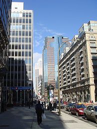
De Maisonneuve Boulevard, Les Cours Mont-Royal at right.Former names: Western, Saint-Luc, Burnside Place Owner: City of Montreal Length: 11 km (7 mi) Location: Between Havre Street and West Broadway Street Coordinates: 45°30′39″N 73°33′54″W / 45.510877°N 73.56508°W Construction Inauguration: November 5, 1966  De Maisonneuve Boulevard West, near Crescent Street.
 Tour Drummond, a building that has since been demolished, contained a tunnel over De Maisonneuve Boulevard.
De Maisonneuve Boulevard (French: Boulevard de Maisonneuve) is a major westbound boulevard located in downtown Montreal, Quebec, Canada. It is named after the founder of Montreal, Paul Chomedey de Maisonneuve. De Maisonneuve Boulevard is about 11 kilometres long and begins on Havre Street in the east end, and ends in the Notre-Dame-de-Grace borough near Concordia University's Loyola Campus. The street also runs through the wealthy enclave of Westmount, where it is one-way, and is cut in two by Westmount Park.
Westmount Square, Dawson College and the now demolished Ben's Deli are all located on this street. Other notable buildings include Grande Bibliothèque du Québec, Université du Québec à Montréal, Place des Arts, both of Concordia University's campuses (Sir George Williams and Loyola) and Montreal Forum.
The green line of the Montreal Metro runs under this street in between Papineau and Atwater; it was constructed under this street to serve Saint Catherine Street to the south without prolonged disruption of activity on that important commercial street. Vendôme station, on the orange line, is also located on this boulevard.
Claire Morissette bike path
In 2007, the city completed a 3.4 km year-round bicycle path along De Maisonneuve through downtown Montreal, from Berri Street to Atwater Street.[1] As of the 2009-2010 winter season, it is the only bike path cleared of snow. A report blamed the path's construction for damage to an underground pedestrian tunnel, part of Montreal's Underground City.[2]
On June 16, 2008, Montreal city council voted unanimously to name the path after the late Montreal cycling activist Claire Morissette.[3]
History
De Maisonneuve was created as a single street in 1966, following the construction of the Metro. From west to east, De Maisonneuve took the route of: Western, from Decarie to Atwater Street; St. Luc, from Atwater to Guy Street; Burnside, from Stanley Street to Union Street; Ontario Street, from Union to Jeanne-Mance, and De Montigny, from Saint Laurent Boulevard to du Havre. Today, Ontario Street still remains, as does a small section of de Montigny, from Saint Laurent to Saint Urbain Street. [4]
References
- ^ "Controversial bike path 'extraordinary' success, city councillor says". Montreal Gazette (Canwest). 2008-10-30. http://www.canada.com/components/print.aspx?id=86440ca1-3b86-42aa-ae7c-ca50fc8695d9. Retrieved 2008-10-30.
- ^ Magder, Jason (2008-02-27). "Bay study blames de Maisonneuve bike path for crack in underground". Montreal Gazette (Canwest). http://www.canada.com/montrealgazette/news/story.html?id=786d5449-0062-45b2-9b34-ddebed2f81da&k=2686. Retrieved 2008-04-16.
- ^ O'Hanley, Stephanie (2008-06-26). "De Maisonneuve bike path named for Claire Morissette". Hour. http://www.hour.ca/news/news.aspx?iIDArticle=14981. Retrieved 2008-08-30.
- ^ Faguy, Steve (2008-03-17). "Montreal Geography Trivia No. 17". Fagstein. http://blog.fagstein.com/2008/03/17/montreal-geography-trivia-no-17/. Retrieved 2008-04-16.
Coordinates: 45°30′39″N 73°33′54″W / 45.510877°N 73.56508°W
Categories:- Streets in Montreal
- Montreal stubs
- Quebec road stubs


Wikimedia Foundation. 2010.